| Home >> | Advanced Search >> |
|
|
|
Astronaut Photography of Earth - Display Record
ISS007-E-14361

Low-resolution Browse Image
(Most browse images are not color adjusted.)Images
Conditions for Use of Images >>Image Transformation Tutorial >> Saving, Color Adjusting, and Printing Images >>
Images to View on Your Computer Now
| File Name | File Size (bytes) | Width | Height | Annotated | Cropped | Purpose | Comments | |
|---|---|---|---|---|---|---|---|---|
| View | ISS007-E-14361.JPG | 49741 | 639 | 435 | No | No | ||
| View | ISS007-E-14361.JPG | 70046 | 540 | 405 | Photographic Highlights | (resized 540 px images) | ||
| View | ISS007-E-14361.JPG | 74879 | 540 | 544 | Yes | Yes | NASA's Earth Observatory web site | |
| View | ISS007-E-14361.JPG | 74879 | 540 | 544 | Yes | Yes | NASA's Earth Observatory web site | |
| View | ISS007-E-14361.JPG | 945987 | 1000 | 886 | No | Yes | NASA's Earth Observatory web site |
Large Images to Request for Downloading
| File Name | File Size (bytes) | Width | Height | Annotated | Cropped | Purpose | Comments | |
|---|---|---|---|---|---|---|---|---|
| Request | ISS007-E-14361.JPG | 286401 | 1024 | 768 | Photographic Highlights | (actual files used) | ||
| Request | ISS007-E-14361.JPG | 819202 | 3032 | 2064 | No | No | ||
| Request | ISS007-E-14361_2.JPG | 4712884 | 6144 | 4068 | No | No | Presentation | Earth Sciences Results Briefing/Ed Lu |
Download a Keyhole Markup Language (KML) file for use in Google Earth.
Electronic Image Data
Camera Files >> No sound file available.Identification
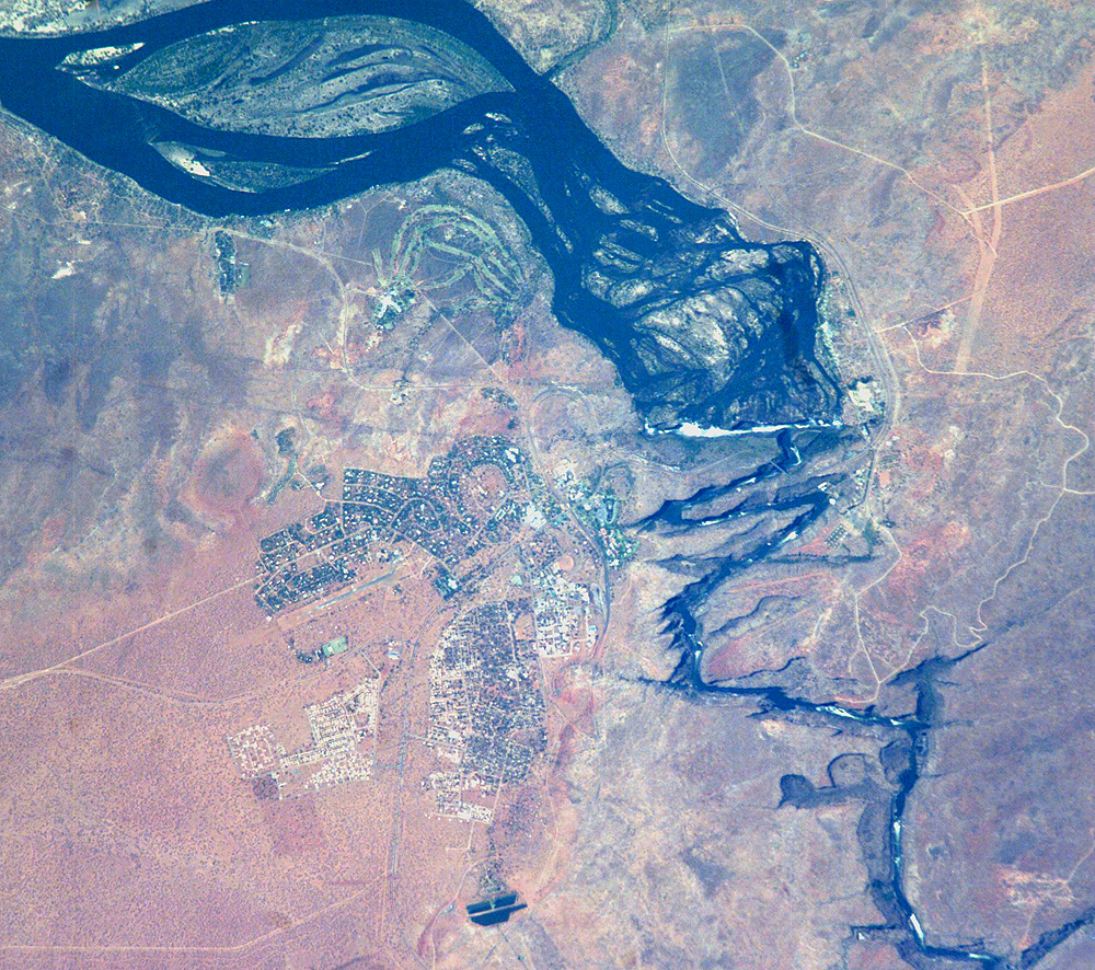
Mission: ISS007 Roll: E Frame: 14361 Mission ID on the Film or image: ISS007Country or Geographic Name: ZIMBABWE
Features: ZAMBEZI RIVER, VICTORIA FALLS
Center Point Latitude: -18.0 Center Point Longitude: 26.0 (Negative numbers indicate south for latitude and west for longitude)
Stereo: (Yes indicates there is an adjacent picture of the same area)
ONC Map ID: JNC Map ID:
Camera
Camera Tilt: 16Camera Focal Length: 800mm
Camera: E4: Kodak DCS760C Electronic Still Camera
Film: 3060E : 3060 x 2036 pixel CCD, RGBG array.
Quality
Film Exposure:Percentage of Cloud Cover: 10 (0-10)
Nadir
Date: 20030904 (YYYYMMDD)GMT Time: 110147 (HHMMSS)Nadir Point Latitude: -17.2, Longitude: 26.6 (Negative numbers indicate south for latitude and west for longitude)
Nadir to Photo Center Direction: Southwest
Sun Azimuth: 333 (Clockwise angle in degrees from north to the sun measured at the nadir point)
Spacecraft Altitude: 205 nautical miles (380 km)
Sun Elevation Angle: 63 (Angle in degrees between the horizon and the sun, measured at the nadir point)
Orbit Number: 3338
Captions
Victoria Falls, Zambezi River: Victoria Falls is one of the most famous tourist sites in subsaharan Africa. Details of the Falls are visible in this image taken with the 800 mm lens by Astronaut Edward Lu from the Space Station on September 4, 2003.A major river in south-central Africa, the Zambezi River flows from western Zambia to the Indian Ocean in Mozambique. In the sector imaged here, it flows southeast (top left to bottom right) in a wide bed before plunging suddenly 130 meters over the Victoria Falls into a narrow gorge. The falls and their famous spray clouds are 1700 m long, the longest sheet of falling water in the world. The falls appear as a ragged white line. The small town of Victoria Falls in Zimbabwe appears just west (left) of the falls, with smaller tourist facilities on the east bank in Zambia. The international railroad bridge over the second gorge (between Zimbabwe and Zambia) can be seen in the detailed view on the bottom (arrow).
The positions of the falls are controlled by linear fault lines in the underlying basalt rocks. The falls have moved upstream (bottom to top) by intense river erosion, elongating the zig-zag gorge in the process. Prior positions of the strongly linear falls can be detected. The earliest on this cropped view may have been the longest (dashed line). The zig-zags represent subsequent positions, all with the characteristic water-worn lip on the upstream side. The falls will continue to erode northward.
Download Packaged File.
This option downloads the following items, packaged into a single file, if they are available:
- Browse image
- Cataloged information with captions
- Camera file
- Sound file
Server: 2 |
This service is provided by the International Space Station program. |
Recommended Citation: |
||

