Western Coastal and Marine Geology
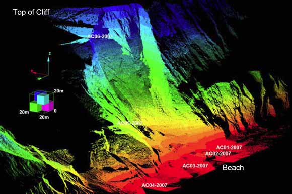
LIDAR setup locations and data coverage for the 2007 landslide event. Color intensity scale is used only to show relative elevation (from figure 8)
On December 20, 2003 and again on January 1, 2007, landslides occurred along the coastal bluff that forms the west boundary of Daly City, California sending debris as far as 290 meters downhill and 90 meters into the ocean. This area is known for large landslide events where 150-meter tall coastal bluffs extend southward along the west boundary of San Francisco and San Mateo Counties (Fig. 1). The 2003 and 2007 landslide events occurred west of Northridge Drive in Daly City and just south of Avalon Canyon, which bisects the bluffs in this area (Fig. 2). Residential development, utility lines and roads occupy the land immediately east of this location. As part of a comprehensive project to investigate the failure mechanisms of coastal bluff landslides in weakly lithified sediments along the west coast of the United States, members of the U.S. Geologic Survey (USGS) Coastal and Marine Geology (CMG) Program performed reconnaissance mapping of these landslide events including collection of high-resolution topographic data using CMG's terrestrial LIDAR laser scanning system.
This report provides a brief background on each landslide event and presents topographic datasets collected following each event. Downloadable contour data, images, and FGDC-compliant metadata of the surfaces generated from the LIDAR data are also provided. LIDAR data collection and processing techniques used to generate the datasets are outlined. Geometric and volumetric measurements are also presented along with high-resolution cross-sections through various areas of the slide masses and discussion concerning the slides present (2007) configuration is provided.
Download this report as a 37-page PDF document (of2007-1079.pdf; 5 MB)
Download data: downloadable contour data, images, and FGDC-compliant metadata of the surfaces generated from the LIDAR data (of2007-1079_data; 21.6 MB total)
For questions about the content of this report, contact Brian Collins
Download a copy of the latest version of Adobe Reader for free.
| Help
| PDF help
| Publications main page | Open-File Reports for 2007 |
| Geologic
Division |
Western Coastal and Marine Geology
|

![]() U.S. Department of the Interior | U.S. Geological Survey
U.S. Department of the Interior | U.S. Geological Survey
URL: http://pubs.usgs.gov/of/2007/1079/
Page Contact Information: Michael Diggles
Page Last Modified: January 9, 2008