
Census Data
The files presented here are based on ![]() U.S.
Census Bureau Tiger files. The eight counties that surround Lake Tahoe
are divided into a numerous
U.S.
Census Bureau Tiger files. The eight counties that surround Lake Tahoe
are divided into a numerous ![]() Census
tracts that include from 2,500 to 8,000 people. They were taken for
the
Census
tracts that include from 2,500 to 8,000 people. They were taken for
the ![]() SEDAC web site
for Census Data download called
SEDAC web site
for Census Data download called ![]() DDCarto.
They were imported into ARC/INFO, combined to cover the Lake Tahoe area,
projected into UTM zone 10 NAD27 and converted to Shape and SDTS file
formats.
DDCarto.
They were imported into ARC/INFO, combined to cover the Lake Tahoe area,
projected into UTM zone 10 NAD27 and converted to Shape and SDTS file
formats.
The original boundary files are available from the U.S. Census Bureau
at ![]() http://www.census.gov/geo/www/cob/tr.html.
http://www.census.gov/geo/www/cob/tr.html.
Click here for an ![]() interactive
Census map of Lake Tahoe vacinity.
interactive
Census map of Lake Tahoe vacinity.
![]()
Data Download
The following Census data have been mosaicked together from the 18 7.5-minute quadrangles that cover the Lake Tahoe Basin. The mosaicked files are more convenient for looking at areas throughout the basin or areas on the edge of two quadrangles.
Census data are in UTM NAD27 zone 10 projection. Raw (original) data are in the following projections: data east of 120 degrees longitude are in UTM zone 11 and data west of 120 degrees longitude are in UTM zone 10. It is not possible to combine different projections in Geographic Information System (GIS), therefore, all data have been reprojected into one standard projection, UTM NAD27 zone 10 projection, for the Lake Tahoe Basin.
 |
The following Census data are stored in three different file formats, each contain the same information:
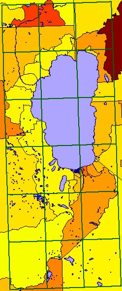
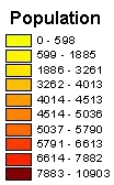
The image on the left shows the census tracts bordering Lake Tahoe colored according to their population density.
|
|
Welcome Digital Data General |

