|
 ENERGY PROGRAM NEWSLETTER ENERGY PROGRAM NEWSLETTER
CONTACT
Don Gautier
Geologist
650-329-4909

|
|
|
Circum-Arctic Resource Appraisal
NEW Circum-Arctic Resource Appraisal GIS datasets:
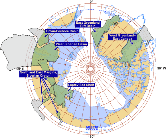
NEW A new map of the Arctic sedimentary successions was assembled (A. Grantz, R.A. Scott, S.S. Drachev, and T.E. Moore, Maps showing the sedimentary successions of the Arctic Region (58°-64° to 90° N) that may be prospective for hydrocarbons (American Association of Petroleum Geologists GIS-UDRIL Open-File Spatial Library, 2009) as the basis for defining CARA assessment units (U.S. Geological Survey, Circum-Arctic Resource Appraisal (north of the Arctic Circle) Assessment Units GIS Data (2009).
GIS-UDRIL Open-File Spatial Library MAP (Note: Map links to a zip folder containing mutiple files, the following readme file explains the Map and its contents: grantzmap_readme.doc)
Circum-Arctic Resource Appraisal: Estimates of
Undiscovered Oil and Gas North of the Arctic Circle
Fact Sheet 2008-3049| Press Release (7/23/08)
Podcast (Episode 55) |  Slide Presentation (Flash document 4.39 MB) Slide Presentation (Flash document 4.39 MB)
Alaskan Petroleum Studies: Improve understanding of Alaskan petroleum—its origin, habitat, and abundance—to improve estimates of undiscovered oil and gas resources.
To access completed assessment results and related reports click on the map below or select from the listing:
| Map Explanation |
| |
|
Assessed Province |
 |
|
Arctic Circle |
| |
|
Arctic Shelf (water depths less than 500m) |
| |
|
Land North of the Arctic Circle |
|
Assessment Fact Sheets
Related Reports
-
Database for Assessment Unit-Scale Analogs (Exclusive of the United States) -- Ver. 1.0, Posted January 2008
Open-File Report 2007–1404
-
Engineering and Economics of the USGS Circum-Arctic Oil and Gas Resource Appraisal (CARA) Project
Open-File Report 2008–1193
|
|
 Arctic Assessment Arctic Assessment
SPOTLIGHT |
Circum-Arctic Resource Appraisal: Estimates of Undiscovered Oil and Gas North of the Arctic Circle
Factsheet 2008-3049
Arctic Assessment Overview
The Arctic is an area of high petroleum resource potential, low data density, high geologic uncertainty and sensitive environmental conditions. A large portion of the remaining global endowment of oil and gas resources has long been thought to exist in the high northern latitudes of Russia, Norway, Greenland, United States, and Canada. However, the quality, quantity, and distribution of these resources are poorly understood.
To improve the understanding of the petroleum resources in this area, the USGS is undertaking a multi-year research effort, termed the Circum-Arctic Resource Appraisal (CARA), to produce a comprehensive, unbiased probabilistic estimate of undiscovered petroleum resources in the high northern latitudes. This research effort is being conducted in collaboration with several U.S. and international entities. When completed, the results from the CARA will provide the first publicly available petroleum resource estimate of the area north of the Arctic Circle in its entirety.
|
|
|
|
|