U.S. Geological Survey - science for a changing world

Energy Resources Program

Regional Studies - Gulf Coast
Energy Home | About Energy | Contact Energy | How Are We Doing?
Energy Sources Regional Studies Health and Environment Geochemistry and Geophysics Most Requested General Information Search Energy Publications and Data


Gulf Coast
Quick links below
Additional Topics

for our newsletterENERGY PROGRAM NEWSLETTER


CONTACT

Russell Dubiel
Lead Geologist
303.236.1540

Peter Warwick
Lead Geologist
703.648.6469


Valid XHTML 1.0 Transitional

Gulf Coast: Introduction

The Gulf Coast Region is a physiographic province extending from Texas to Florida and encompasses the coastal plain, low hills, and deltas of the Gulf of Mexico. This is a geologically stable area characterized by low relief terraces extending to the continental shelf. Sediments consist of coastal plain deposits and thick land-derived sediments prograding from the Mississippi River delta system; ultimately transitioning to evaporite and carbonate deposits offshore. Coastlines exhibit wave and delta dominated features and landforms such as barrier islands, bays, and marshes. The Mississippi River also supports a diverse economy in the region. A large percentage of the present and future energy resources of the United States are located in the Gulf Coast Region, highlighting the importance for energy research and assessments. This web site provides access to the Energy Resources Program research activities and products within the Gulf Coast Region.

A Landsat7 satellite image of Louisianna silt.

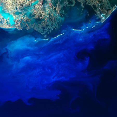
A Landsat 7 satellite image of Louisianna silt: Landsat 7's blue band can see some distance into coastal water, which makes silt appear blue as it flows off of the southern coast of Louisiana and into the Gulf of Mexico. The brightness and shade of blue depend on the density of the silt and the depth of the silt-carrying currents in the water. Small bright dots in the scene are fishing boats and oil platforms.


spotlightGULF COAST
SPOTLIGHT


Assessment of undiscovered oil and gas resources in Tertiary strata and Cretaceous-Tertiary coalbed gas of the Gulf Coast, 2007:
USGS Fact Sheet FS-2007-3066

Assessment of undiscovered oil and gas resources in Cretaceous-Tertiary coal beds of the Gulf Coast Region, 2007:
USGS Fact Sheet FS-2007-3039


RECENT PUBLICATIONS

Assessment of Undiscovered Gas Resources in the Upper Cretaceous Tuscaloosa and Woodbine Formations, Western Gulf Province of the Gulf Coast Region, Louisiana and Texas, 2007:
USGS Fact Sheet FS-2006-3146


RELATED LINKS

USGS Gulf of Mexico Integrated Science Web site

USGS National Wetlands Research Center

Coastal and Marine Geology Program Internet Map Server: U.S. Gulf of Mexico region

Top of Page

Accessibility FOIA Privacy Policies and Notices

Take Pride in America home page. FirstGov button U.S. Department of the Interior | U.S. Geological Survey
URL:
Page Contact Information: ERP Webmaster
Page Last Modified: