BROWSE CATEGORY - Posters 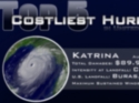 | Poster: Top 5 Costliest Hurricanes
This poster-sized image shows the top 5 hurricanes that have caused the most monetary damage to property in the United States. Values are calculated as of 2008, but are not adjusted for inflation. |  | Poster: The Largest Ozone Hole
In 2006, satellites revealed the largest ozone hole ever recorded over Antarctica. This poster shows monthly images from the NOAA POES satellite, documenting changes in global ozone concentration. |  | Poster: Hurricane Katrina
This poster-sized image is from the GOES-12 satellite showing Hurricane Katrina on August 28, 2005 at maximum intensity with 175 mph winds (Category 5). |  | Poster: The Wrath of Hurricane Katrina
This poster shows 4 GOES-12 1 km visible satellite images of Hurricane Katrina as it forms and then intensifies in the Gulf of Mexico and makes landfall in Louisiana August 23-29, 2005. | |
|
|