SURFRAD (Surface Radiation) Network

Information:

Overview

Stations

Calibrations

Aerosol Optical Depth

ISIS Network

Sky Imagers

Other US Networks

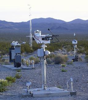
Desert Rock SURFRAD station, including (clockwise from left center) radiometer platform, met tower, TSI and solar tracker.

SURFRAD Data:

Rad/Met Plots

AOD Plots

Monthly Means

Soundings

TSI Images

Data Download (FTP)
Click here if FTP fails.

Problems


NOTICE: A more accurate solar zenith angle calculation has been implemented in SURFRAD data processing, and all SURFRAD data has been reprocessed to include this change. See the problems link for details.