Colorado State Archives
Geography Page
Maps of Colorado
Links to
Historical Maps of Colorado
Congress created the Territory of Colorado in 1861 in the center of the western half of the
continental
United States in the east-central portion of the Rocky Mountain region. The center of the state is
approximately 1,500 miles west of the Eastern coast of the United States, 800 miles east of the
Western
coast, 650 miles south of the northern border with Canada and 475 miles north of the southern
border
with Mexico. Colorado is bounded on the east by the states of Kansas and Nebraska, on the
north by
Nebraska and Wyoming, on the west by Utah and on the south by New Mexico and Oklahoma.
The
boundary lines create an almost perfect rectangle, measuring approxiamtely 387 miles from east
to west
and 276 miles from north to south and covering 104,247 square miles, including 450 square
miles of
bodies of water. Colorado is the eighth largest state when measured in square miles area.
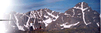
Colorado is a diverse region of mountains, plateaus, canyons and plains. Generally, the eastern
half of
the state has flat, high plains and rolling prairies gradually rising westward to the front range
foothills
and the higher ranges of the Rocky Mountains. The Continental Divide runs from north to south
through
west central Colorado and bisects the state into the eastern and western slopes. The western half
of the
state consists of alpine terrain interspersed with wide valleys, rugged canyons, high plateaus and
deep
basins.
Colorado's altitude is one of its distinctive geographical features making it on average, the
nation's
highest state. The average elevation is 6,800 feet. The lowest elevation in Colorado is
3,315 feet on the Arikaree River where it flows into the northwestern corner of
Kansas. Colorado's highest peak is Mt. Elbert at 14,431 feet
high, or
2.72 miles above sea level. Mt. Elbert is the 14th highest peak in the United States, including
mountain
peaks in the state of Alaska. In addition, there are 54 mountain peaks in Colorado over 14,000
feet
high and more than a thousand peaks over 10,000 feet high.
Colorado's mountainous regions also are the headwaters for six major rivers. The Continental
Divide, so
named because waters west of the divide flow toward the Pacific ocean and those east of the
divide flow
toward the Atlantic ocean, runs from north to south through the state. West of the Continental
Divide,
the Colorado River, for which our state was named, flows southwest from high in the Rocky
Mountains
in north central Colorado toward the Gulf of California. East of the Continental Divide, the
North Platte,
the South Platte, the Arkansas, the Republican and the Rio Grande rivers
all originate in Colorado's
mountains or plains and flow east toward the Missouri River, southeast to
the Mississippi River and then south to
the Gulf of Mexico.
The eastern, western and south central parts of the state are noted for agricultural production of a
wide
range of crops, depending on the area. Farming of both dry and irrigated land is common in the
eastern
part of the state as well as is livestock grazing. Fruits such as
apples, peaches, cherries, grapes and apricots are
grown successfuly on the western slope. Melons and vegetables are grown successfullly in the
San Luis
and Arkansas Valleys. Colorado's main agricultural products are grains, beef, fruit and
vegetables.
Historically, the economy of Colorado was based on mining. The discovery of gold in 1858
began
much of the westward migration to the state. Later, production of silver, uranium, coal,
molybdenum
and petroleum all contributed to the state's boom and bust economy. Much of the economy
now
centers around high technology and the service industry.
Comments & Requests |
Privacy Statement
|
Disclaimer