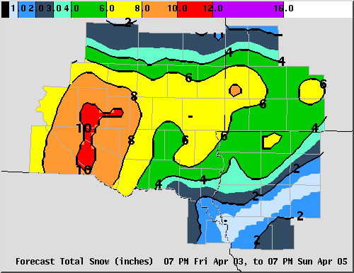
Experimental Event Total
Snowfall Forecast

Please Note: This Event Total Snowfall Forecast graphic will be displayed
only when significant snowfall is expected within the next 72 hours.
Please check the HAZARDOUS WEATHER OUTLOOK, the 6-hourly snowfall amounts and forecast weather on our FORECAST GRAPHICS PAGE, or the latest WINTER WEATHER MESSAGE  for further detail regarding specific amounts and timing. 

Event Total Snowfall Forecast - This graphic will only be displayed when significant snowfall is expected within the next 72 hours.

Key for Total Snowfall Map:
Black = less than 1/2 inch. <1/2": Black
Purple = 1/2 inch to 2 inches. 1/2"-1": Light Blue
  1"-2": Medium Blue
Blue = 2 to 4 inches. 2"-3": Dark Blue
  3"-4": Light Green
Cyan = 4 to 6 inches. 4"-6": Green
Green = 6 to 8 inches. 6"-8": Yellow
Yellow = 8 to 10 inches. 8"-10": Orange
Orange = 10 to 12 inches. 10"-12": Red
Red = 12 to 16 inches. 12"-16": Purple
White = greater than 16 inches. >16": White

  • National Weather Service
  • Sioux Falls, SD Weather Forecast Office
  • 26 Weather Lane
  • Sioux Falls, SD 57104-0198
  • 605-330-4247
  • Page Author: FSD Webmaster
  • Web Master's E-mail: w-fsd.webmaster@noaa.gov
  • Page last modified: January 10th 2008 9:21 PM
USA.gov is the U.S. government's official web portal to all federal, state and local government web resources and services.