- What
is an El Niño?
About El Niño
Click here for:
Different aspects of El Niño
- Is El Niño a theory or a fact?
El Niño as a physical occurrence is a proven fact. The way it works
is a theory (actually several different theories). El Niño is as
real as other weather phenomena: thunderstorms, for instance. We recognize
its characteristics as similar to previous occurrences, and note that
its life cycle is roughly the same each time. (Of course each one is different,
as each thunderstorm is different, but the basic evolution is similar
enough that we know an El Niño when we see it). (See below for
web pages where you can view data from the Pacific).
On the other hand, a difference from thunderstorms is that we have
a very good idea what triggers thunderstorms, what conditions make it
likely for them to occur, to the point where weather forecast models
commonly pinpoint the locations and predicted severity of thunderstorms
a day or so in advance. We do not have such knowledge for El Niño.
Once an El Niño has started, we have reasonably good skill in
predicting the subsequent evolution over the next 6-9 months, but before
it has started we have very little skill in predicting the onset before
the event has become obvious. There are a variety of theories for why
EL Niños start, but none of them has given us real skill in making
a forecast in advance, the way we can for thunderstorms.
It must be said that there is still plenty of social utility in predicting
the evolution of an El Niño after it starts, since that gives
6 months or so warning before the effects come to the US. For instance,
a fairly weak El Niño started earlier this year, and that enables
forecasters to predict that the coming winter is likely to be warmer
than normal across the northern states, and wetter than normal along
the Gulf Coast. Such forecasts are certainly useful for farmers and
water managers, but from a scientific point of view they are unsatisfying
because they do not answer the fundamental question of why the event
started in the first place.
One reason for this state of affairs is that El Niños only
come along every 4-5 years or so, so there aren't very many to study
(we've had decent instrumentation in the tropical Pacific for less than
20 years). Thunderstorms happen every day in summer, so there's been
lots of opportunity to carefully observe their development.
Perhaps this is a deeper question, though, concerning the meaning
of the word "theory". In science, we use the word theory somewhat differently
from ordinary usage. Ordinarily, to say something is a theory means
it is kind of a guess, not proven. Scientists, on the other hand, speak
of the "theory of gravitation", or the "theory of evolution", and in
that case it means the precise description of the mechanism. In no way
does it indicate that the phenomenon in question is less than a fact.
No one doubts that gravity is a fact, but the exact way it works is
still a subject of research (Einstein spent the last 40 years of his
life trying to explain gravitation without simply postulating it, that
is, to explain it in connection with the other atomic forces. This is
still a major question of physics, and you may have heard of the search
for a "unified field theory"). Similarly, no serious scientist doubts
that evolution is a fact, but there is plenty of discussion about its
specific mechanisms, whether it happens fast or slowly, what size population
of an organism is likely to produce new species, under what conditions
a species will die out, etc). All these are part of honing the theory.
In the case of El Niño, one theory is that these events are the
means by which heat is drained from the equatorial oceans after a period
of accumulation. Such a theory predicts that by observing the growth
of heat content, it should be possible to forecast when an El Niño
will occur. That seems to be at least partly true, but it was contradicted
by the El Niño of 1993, which occurred immediately after one
the previous year, and no accumulation had occurred. Another theory
argues that El Niños are triggered by random events occurring
in other parts of the climate system, and suggests that we will never
be able to predict them. Some scientists argue for an opposite (cold)
phase called La Niña, and see the whole thing as an oscillation
swinging back and forth, while others think there is just the normal
situation disturbed by occasional El Niños. However, you can
see that despite the existence of competing theories for El Niño,
there is no doubt that it is a real, factual occurrence.
You can see data for the tropical Pacific at:
http://www.pmel.noaa.gov/tao/jsdisplay/
For example, click the "Assorted plots" button, then pull down the
menu and click "Monthly EQ UWND SST 20C anoms", which shows the simulataneous
changes of zonal (east-west) wind, SST (sea surface temperature) and
20C isotherm depth (the depth of the interface between the warm upper
water and the cold abyss). You will get a small plot; click on that
to make it bigger). El Niños are marked by simultaneous westerly
(from the west) winds, warm SST and deep interface, and occurred in
1986, 1991-92, 1993 (the weak one I mentioned earlier), 1994-95, 1997-98
(an extremely strong one) and you can see the present one developing.
The fact that these are reasonably well-defined occurrences in these
different variables, though with different amplitude in different years,
shows that there really is a thing called El Niño.
There is lots of various El Niño information (including many
other links) on this website:
http://www.pmel.noaa.gov/tao/elnino/
Forecasts for the coming months are given at:
http://www.elnino.noaa.gov/forecast.html
There is a description of how it works on Dr. Billy Kessler's FAQ
page:
http://www.pmel.noaa.gov/~kessler/occasionally-asked-questions.html
See question 1.
- Why is it called El Niño?
El Niños were originally recognized by fisherman off the coast
of South America as the appearance of unusually warm water in the Pacific
ocean, occurring near the beginning of the year. El Niño means
The Little One in Spanish. This name was used for the tendency
of the phenomenon to arrive around Christmas. There has been a confusing
range of uses for the terms El Niño, La Niña and ENSO by
both the scientific community and the general public, which is clarified
in these web pages on What
is the origin of the names El Niño and La Niña? and
definitions
of the terms ENSO, Southern Oscillation Index, El Niño and La Niña.
- Would you be able to give me some feed back on how we as global
citizens can do something about el nino and its effects?
El Niño happens when tropical Pacific Ocean trade
winds die out and ocean temperatures become unusually warm. There
is a flip side to El Nino called La Nina,
which occurs when the trade winds blow unusually hard and the sea temperature
become colder than normal. El Nino and La Nina are the warm and cold
phases of an oscillation we refer to as El Nino/Southern Oscillation,
or ENSO, which has a period of roughly 3-7 years. Although ENSO originates
in the tropical Pacific ocean-atmosphere system, it has effects on patterns
of weather variability all over the world. It also affects Pacific marine
ecosystems and commercially valuable fisheries such as tuna, sardines,
salmon, and Peruvian anchovetta.
Information contained in the chemical composition of ancient tropical
Pacific coral skeletons tells us that ENSO has been happening for at
least 125 thousand years. This span of time covers the last ice age
cycle when the earth's climate was cooler and very different from today's
climate. In addition, we can reasonably assume that the ENSO cycle has
been operating ever since geologic processes closed the Isthmus of Panama
about 5 million years ago to form the modern boundaries of the Pacific
basin.
There is nothing we can do to stop El Nino and La Nina events from
occurring. The year-to-year oscillations between normal, warm, and cold
conditions in the tropical Pacific associated with the ENSO cycle involve
massive redistributions of upper ocean heat. For instance, the accumulation
of excess heat in the eastern Pacific during a strong El Nino like that
which occurred in 1997-98 is approximately equivalent to the output
of one million medium-sized 1000 megawatt power plants operating continuously
for a year. The magnitude of these natural variations clearly indicates
that society cannot hope to consciously control or modify the ENSO cycle.
Rather, we must learn to better predict it, and to adapt to its consequences.
The challenge for physical scientists therefore is to improve ENSO
forecast models, to improve our understanding of underlying physical
processes at work in the climate system, and to improve the observational
data base needed to support these goals. Capitalizing on advances in
the physical sciences for practical purposes is a challenge for social
scientists, economists, politicians, business leaders, and the citizenry
of those countries affected by ENSO variations. The promise of the future
is that continued research on ENSO and related problems will be rewarded
with new scientific breakthroughs that translate into a broad range
of applications for the benefit of society.
- Why does El Niño occur?
El Niñoresults from interaction between the surface layers of the
ocean and the overlying atmosphere in tropical Pacific. It is the internal
dynamics of the coupled ocean-atmosphere system that determine the onset
and termination of El Niño events. The physical processes are complicated,
but they involve unstable air-sea interaction and planetary scale oceanic
waves. The system oscillates between warm (El Niño) to neutral
(or cold) conditions with a natural periodicity of roughly 3-4 years.
External forcing from volcanic eruptions (submarine or terrestial) have
no connnection with El Niño. Nor do sunspots as far as we know.
- How often does El Niño occur?
El Niños usually occur irregularly, approximately every two to
seven years. Look at the CAC Sea Surface Temperature (SST) Anomalies in the latest Climate Diagnostics Bulletin for the Eastern Equatorial
Pacific Ocean. The region named "Niño
3", which is 150W to 90W, 5N to 5S. The El Niño years
1976-1977, 1982-1983, 1986-1987, 1991-1994, and are distinguished by large
SST anomalies. The first half of the 1990s is unusual in that the past
four years have all been unusually warm in the equatorial Pacific. See
The 1990-1995 El
Niño-Southern Oscillation event: Longest on record. Kevin E.
Trenberth and Timothy J. Hoar. Geophysical Research Letters, Vol. 23,
No. 1, pp 57-60. January 1, 1996. and The Record Setting 1990-95 El Niño:
Harbinger of a Changing Climate? UCAR News Release, 5 January 1996. See
recent El Niño Information.
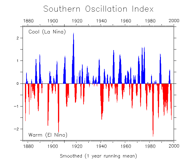
- Where is a list of El Niño and La Niña years?
Lists of El Niño and La Niña years
are published at several sites on the Web:
Here is a graph showing El Niño and La Niña years
since 1950 and
going back to 1876, as indicated by the
Southern Oscillation Index.
- Are all El Niños the same?
Every El Niño is somewhat different in magnitude and in duration.
Magnitude can be determined in different ways, such as variations in the
Southern Oscillation Index (SOI). Plots of Sea Surface Temperature Anomalies
(SSTA) from the
ENSO Montitor, show El Niños back to 1982, including the 1982-1983
El Niño, which, until 1997, was the largest El Niño of this
century. Another comparison of different El Niños can be seen in
plots
of Sea Ssurface Temperature Anomalies from
CPC for different regions (Niño 1,2,3,4)
in the Pacific Ocean. The Niño 3
region, in the Eastern Equatorial Pacific Ocean, extends from 150W to
90W and 5N to 5S. The El Niño in 1982-1983 had far stronger sea
surface temperatures in the Niño 3 region than El Niños
in 1976, 1987, and 1991. Another comparison of El Niños is available
from the CDC as plots of an
El Niño index for comparison of El Niño events back
to 1950.
In a plot of
Sea Surface Temperature along the Equator from 1986-present, you
can see that warm water (red) penetrated further to the East in the
1986 and 1997 El Niños than it did during the 1991-1993 El Niños.
 Click here to see today's conditions
compared with others in the twentieth century in plots and animations.
Click here to see today's conditions
compared with others in the twentieth century in plots and animations.
- Do El Niño events occur only in the Pacific Ocean?
The great width of the Pacific Ocean is the main reason we see El Niño
Southern Oscillation (ENSO) events in that ocean as compared to the Atlantic
and Indian Oceans. Most current theories of ENSO involve planetary scale
equatorial waves. The time it takes these waves to cross the Pacific is
one of the factors that sets the time scale and amplitude of ENSO climate
anomalies. The narrower width of the Atlantic and Indian Oceans means
the waves can cross those basins in less time, so that ocean adjusts more
quickly to wind variations. Conversely, wind variations in the Pacific
Ocean excites waves that take a long time to cross the basin, so that
the Pacific adjusts to wind variations more slowly. This slower adjustment
time allows the ocean-atmosphere system to drift further from equilibrium
than in the narrower Atlantic or Indian Ocean, with the result that interannual
climate anomalies (e.g. unusually warm or cold Sea Surface Temperatures)
are larger in the Pacific.
There is another way in which the width of the Pacific allows ENSO
to develop there as compared to the other basins. In the narrower Atlantic
and Indian Oceans, bordering land masses influence seasonal climate
more significantly than in the broader Pacific. The Indian Ocean in
particular is governed by monsoon variations, under the strong influence
of the Asian land mass. Seasonally changing heat sources and sinks over
the land are associated with the annual migration of sun. Heating of
the land in the summer and cooling of the land in the winter sets up
land-sea temperature contrasts that affect the atmospheric circulation
over the neighboring ocean. This land influence competes with ocean
and atmosphere interactions which are essential for generating ENSO.
See Indian Ocean
may have El Niño of Its Own, from the American Geophysical
Union EOS publication.
- What is a La Niña?
La Niña
is characterized by unusually cold ocean temperatures in the equatorial
Pacific, as compared to El Niño, which is characterized by unusually
warm ocean temperatues in the equatorial Pacific.
La Niña is also sometimes called El Viejo.
At higher latitudes, El Niño is only one of a number of factors
that influence climate. However, the impacts of El Niño and La
Niña at these latitudes are most clearly seen in wintertime.
In the continental US, during El Niño years, temperatures in
the winter are warmer than normal in the North Central States, and cooler
than normal in the Southeast and the Southwest. During a La Niña
or El Viejo year, winter temperatures are warmer than normal in the
Southeast and cooler than normal in the Northwest.
See lists of El Niño and La Niña years.
- What is the current El Niño Forecast or Advisory?
The Climate Prediction Center of the National Center for Enviromental
Prediction provides an
El Niño Advisory, which is updated every month. They also publish
a monthly
Climate Diagnostics Bulletin. See http://www.pmel.noaa.gov/tao/elnino/forecasts.html
for links to El Niño advisories from several forecasting centers
located throughout the world.
Realtime Pacific
Ocean data from the NOAA network of moored buoys is updated daily
to show the current conditions in the Equatorial Pacific Ocean.
- What is the present climate in different countries in the world?
The Climate Analysis Center at the U.S. National Center for Environmental
Prediction provides up to date
Reginal Climate Monitoring information from many parts of the world.
The Climate Prediction Center issues
special climate summaries which monitor current and developing climate
variations. These are current, and very interesting.
Current conditions and typical global impacts are also discussed
in the NCEP pages.
- How do we detect El Niño?
In the tropical Pacific Ocean, El Niños are detected by many methods,
including satellites,
moored buoys,
drifting buoys,
sea level analysis, and XBTs.
Many of these in-situ ocean observing systems were part of the
Tropical Ocean Global Atmosphere (TOGA) program,
and are now evolving into an
operational El Niño/Southern Oscillation (ENSO) observing system.
For a look at operations aboard NOAA's newly commissioned research
ship, which is dedicated to servicing the TAO bouy network component
of the ENSO observing system, please see realitme
images and data from the KA'IMIMOANA.
Large computer models of the global ocean and atmosphere, such as
those at the National Centers
for Environmental Prediction use data from the
ENSO observing system as input to predict
El Niño. Other models are used for El Niño research, such
as those at NOAA's Geophysical Fluid
Dynamics Laboratory, at
Center for Ocean-Land-Atmosphere Studies, and other research institutions.
- What indices are used to see if an El Niño or La Niña
is occurring?
A variety of indices
are used to characterize ENSO because it effects so many elements of
the atmosphere-ocean climate system. Probably the two principal indices
are the Southern Oscillation Index (SOI), which is given by the difference
in sea-level pressure between Tahiti and Darwin, Australia, and the
Nino 3 index, which referes to the anomalous SST within the region bounded
by 5N-5S and 150W-90W. The measurements needed for these indices are
straightforward, and we have long historical records, especially for
the the SOI.
However, other indices are effective at characterizing other aspects
of ENSO. For example, the anomalous 850 mb zonal winds show how the
low-level atmospheric flow is responding to low-level pressure anomalies
associated with ENSO and other mechanisms. Often the 850 mb flow (about
1.5 km above sea level) exhibits a "cleaner" signal than the
winds at the surface, which are subject to local effects such as terrain.
An index involving the 200 mb zonal flow is used to describe the upper
tropospheric winds, whose anomalies tend to be opposite to those at
850 mb and below. The 200 mb flow is particularly important because
it is changes at around this level in the tropics that tend to have
the biggest consequences for the atmospheric circulation outside of
the tropics. The 500 mb temperature represents a proxy for the anomalous
heat content of the tropical troposphere. In an overall sense, there
is greater heating of the troposphere, and more deep cumulus convection,
than normal during warm ENSO events (El Ninos).
Finally, there is one more widely used index for the atmosphere and
that relates to the outgoing longwave radiation or OLR. The deeper the
cumulus convection, the colder the cloud tops, which means the thermal
or infrared radiation to space is reduced. It is straightforward to
monitor OLR via satellite; its value in the tropical Pacific near the
dateline is an effective way to gauge the frequency and magnitude of
the thunderstorm activity that changes with ENSO.
Current values
of these indices provided on-line by the Climate Prediction Center.
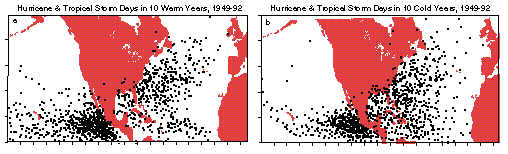
- What is the relationship between hurricanes and El Niño?
In general, warm ENSO episodes are characterized by an increased number
of tropical storms and hurricanes in the eastern Pacific and a decrease
in the Gulf of Mexico and the Caribbean Sea. A figure that shows tropical
storm locations is available from
the University of Washington. Tropical weather products pages are
available on the Web from the
University of Michigan and from the
University of Hawaii.
Hurricane Forecasts and Hurricane Information web pages are maintained
by the Federal Emergency Management Agency
(FEMA).
Atlantic Ocean
It is believed that El Niño conditions suppress the development
of tropical storms and hurricanes in the Atlantic; and that La Niña
(cold conditions in the equatorial Pacific) favor hurricane formation.
The world expert in this area of study is Prof. Bill Gray of Colorado
State University. Please see their Web pages, including
Frequently asked Questions about Hurricanes, Typhoons and Tropical Cyclones.
The Tropical Meteorology
Project at Colorado State University maintain Web pages on
Forecasts (Hurricanes, ENSO, African Sahel Rainfall, etc.).
Pacific Ocean
El Niño tends to increase the numbers of tropical storms in the
Pacific Ocean. For details, see the information about the
location and numbers of tropical cyclones in the Eastern Pacific for El
Niño and non-El Niño years (scroll to bottom of page)
from the Pacific
ENSO Applications Center in Hawaii.
- What is the relationship between coral bleaching and El Niño
/ La Niña ?
Coral bleaching results when sea temperature rises above a threshold (about
28C) beyond which corals expel colorful symbiotic algae (hence the bleaching).
Deprived of metabolic by-products generated by algae for extended periods,
corals die. Coral bleaching was particularly pronounced during 1997-98
because a very strong El Niño occurred that year and the El Niño
related rises in sea temperature were superimposed on a slow upward sea
temperature warming trend in some parts of the Pacific and Indian Oceans
that may be linked to global warming.
If you type in "coral bleaching and El Niño" on a web search
engine, you will find lots of web sites that describe coral bleaching
and its relation to El Niño.
- What is the relationship between greenhouse warming, El Niño
/ La Niña and climate prediction?
There is a lot of confusion in the public about the interrelations
connecting climate phenomena such as El Niño, La Niña and
greenhouse effect. Is it true that a warmer atmosphere is likely to produce
stronger or more frequent El Niños?
We don't know the answer to this question. It is certainly a plausible
hypothesis that global warming may affect El Niño, since both
phenomena involve large changes in the earth's heat balance. However,
computer climate models, one of the primary research tools for studies
of global warming, are hampered by inadequate representation of many
key physical processes (such as the effects of clouds on climate and
the role of the ocean). Also, no computer model yet can reliably simulate
BOTH El Niño AND greenhouse gas warming together. So, depending
on which model you choose to believe, you can get different answers.
For example, some scientists have speculated that a warmer atmosphere
is likely to produce stronger or more frequent El Niños, based
on trends observed over the past 25 years. However, some computer models
indicate El Niños may actually be weaker in a warmer climate.
This is a very complicated (but very important!) issue that will require
further research to arrive at a convincing answer.
Both 1998 and 1997 had record-setting global mean temperatures
and also El Niño. What influences what?
El Nino clearly influences globally averaged temperatures which go
up a few tenths of a degree C a few months following the peak warming
in the tropical Pacific. This is because the tropical Pacific loses
large amounts of heat to the overlying atmosphere during El Niño.
So some of the extreme warming observed in global temperatures in 1997-98
can be traced back to the occurrence of El Nino in the tropical Pacific.
However, underlying the El Nino effect (which should diminish in the
next year) is an long term global trend towards warmer temperatures.
Two questions arise, for which we do not have answers at this point:
1) Exactly how much of the extreme rise in global temperatures during
1997-98 was due to the 1997-98 El Nino, versus the contribution from
the underlying long term trend? and 2) Did the extreme El Nino occur
in response to global warming trends? This second question ties into
your first question above. In fact, how global warming projects onto
natural modes of climate variability like El Nino, the Pacific Decadal
Oscillation, and the North Atlantic Oscillation (all of which can have
an affect on global air temperatures) is a very compelling research
problem.
Could the problem of disentangling the many factors and dynamics
at play in El Niño and global warming can be compared to writing
down the scores of many different tunes whilst they are played all at
the same time. Might cacophony be a good image to describe circulation
patterns?
That's a nice analogy. However, it could be refined in the following
way: when the scores are played together, they not only become entangled,
but they may actually metamorphose into a slightly different tune, one
for which no score existed at the start of the piece. That is to say,
that El Nino, global warming, and other climate signals are actually
physically altered by their interaction in ways you would not expect
by considering them in isolation. Sorting out these complex interactions
is in fact one of the major challenges of climate research today.
For more information, see
Why can't I find any information about links between El Niño
and global warming?
- What is the relationship between the Earth's rotation, the Coriolis
force, and El Niño and La Niña?
El Nino results in a decrease in the earth's rotation rate, an increase
in the length of day, and therefore a decrease in the the strength of
the Coriolis force. La Nina tends to have the opposite effect.
El Nino is associated with a weakening of the tropical Pacific trade
winds, and also with a strengthening of the mid-latitude westerlies
both at the surface and aloft. To balance these changes in atmospheric
winds, the earth's rotation rate decreases in order to conserve total
angular momentum of the earth/atmosphere system. Conservation of angular
momentum is a basic physical principal which operates, for example,
when a ballerina brings her arms closer to her body to spin faster.
The change, however, is only about 1 millisecond at the peak of a strong
El Nino. There are 86400 seconds in a day, so this change represents
one part in 100 million. Such a change will have little effect on normal
activities on a human scale, such as flying an airplane.
- Is it feasible to haul icebergs from Antarctica to the tropical
Pacific to cool down El Niño?
The answer is "NO".
The simple reason is that to cool the tropical Pacific down to its
normal state once an El Nino is underway would take an amount of ice
10 m thick covering an area equal in size to the continental US. That's
a lot of ice, and there's no way to extract and transport that amount
of ice with existing technology. Even if it were technically feasible,
it would in all likelihood cost an astronomical amount of money, many
times over the combined global losses due to El Nino.
Furthermore, it would take a long time to transport. The inevitable
delays that attend any grand project would probably mean you'd get all
the ice to the tropical Pacific just as the El Nino was ending. It would
be too late to do any good. But worse, since El Nino is often followed
by La Nina (which has it's own set of adverse consequences on weather),
you could end up exacerbating the effects of natural climate variability
on society.
Finally, the extraction of that much ice would seriously damage the
environment of Antarctica. It could also have potentially serious consequences
on global climate if it lead to changes in surface reflection of sunlight,
or had other effects on land surface processes.
So economically and environmentally, it's a much better strategy to
invest in research on how to better predict El Nino, and to invest in
developing ways to adapt to its impacts on society.
- What are the implications of our observations of the 1997-1998 El
Niño on prediction? Is ENSO more difficult to predict than
we had thought?
The scientific community has made tremendous advances in forecasting El
Nino in the past 15 years. For example, we had NO forecasting capability
at all prior to the 1982-83 El Nino. Many computer models correctly forecast
that 1997 would be unusually warm in the tropical Pacific. That is a major
advance by any measure, because just knowing that the tropical Pacific
will be warm (or cold) a season or two in advance provides great leverage
in making more reliable long range weather forecasts around the globe.
(This is a VERY OPTIMISTIC message). On the other hand, the forecast models
missed the rapid onset, the great magnitude, and the sudden demise of
the 1997-98 El Nino, possible due to weather noise that is inherently
unpredictable more than about 2 weeks in advance. What that means is that
there may be some inherent limits to how accurately we can hope to predict
El Nino (admittedly a somewhat pessimistic message). However, the 1997-98
El Nino will serve as a stimulus for improving forecast models, because
forecast skill is not only limited by climate noise, but also by imperfect
model physics, and incomplete and imperfect data for initializing forecasts.
These are areas where we can certainly expect to see progress in the the
coming years (again, an OPTIMISTIC message).
- Was the strong 1998-1999 La Niña related to severe winter
weather in the northern hemisphere?
The 1998-1999 La Niña made itself felt in the US.
The seasonal forecast for wintertime conditions, based in large part on
the evolving temperatures in the tropical Pacific captured many of
the large scale patterns of temperature and precipitation of the continental
US. In the Pacific Northwest, for example, the three month period November
1998 - January 1999 was the wettest on record. Also, this winter was
warmer and drier over large portions of the southern US, from California
to Florida. One forecast "miss" was that the upper mid-west was predicted
to be colder than normal this winter, but was a little warmer
than normal, at least initially.
- Why was El Niño such a big deal in 1998?
It is an interesting question to ask why El Niño suddenly became
headline news in 1998. The scientific community has known about
El Niño and it's impacts on global weather, Pacific marine ecosystems,
and fisheries for about 35 years. The regional impacts
of El Niño along the coast of South America have been known
for hundreds of years by the people living in that area. There are three
factors though that made reporting of the 1997-98 El Niño different
from other recent El Niño events.
1. The 1997-98 El Niño was the strongest
on record, and it developed more rapidly than any El Niño of
the past 40 years. As a result, we started to see it impacts on weather,
marine ecosystems and fisheries very quickly, and these impacts were
spectacular. Early effects in August-October 1997 included record flooding
in Chile, Marlin caught off the coast of Washington, the extensive smog
cloud over Indonesia, and a quiet Atlantic hurricane season. The press
is geared towards reporting sensational stories, and this El Niño
provided high drama through natural disasters and other unusual events.
2. In the past 15 years, scientists developed new observational tools
that allowed us to track the development of El Niño in greater
detail than ever before. The new observations, from satellites
and from sensors in
the ocean itself, provided a day by day account of events as they
unfolded in the tropical Pacific. These technological advances, providing
high definition information on the tropical ocean and atmosphere system
like never before, fueled a lot of interest in the press about El Niño,
how we track it, and how it affects people's lives.
3. Another technological advance in the past 15 years was the development
of long range forecasting capabilities
for predicting the evolution of El Niño sea surface temperatures,
and the consequences of those temperatures on global weather. The effects
of El Niño on North American climate are most pronounced in the
winter season. Because the El Niño developed so rapidly, with
record high sea surface temperatures in the equatorial Pacific by July
1997, forecasters could predict a full 6 months in advance with some
reliability that the winter over the US would be very unusual. The credibility
of these forecasts was high, because of the clearly identifiable impacts
of El Niño earlier in the year (see point 1 above). The anticipation
of an unusual winter motivated a lot of disaster preparedness efforts
by local and state governments, by the federal government, by businesses,
and by individuals. This mobilization of people and resources based
on a climate forecast was unprecedented, and therefore caught the attention
of the press. Once winter arrived, the predicted unusual weather set
in, and that was also newsworthy. It turns out that the forecasts for
heavy rains over the southern part of the US for the winter of 1997-98,
and for an unusually mild winter in the Midwest proved to be largely
correct. Record rains occurred in particular in California and Florida,
two of the most populous states in the nation.
- Has a reasonable, scientific body come
up with any meaningful conclusions and/or predictions in the field
of physical oceanography regarding forcasting of the ocean?
Regarding forecasting of the ocean, you may want to check out the
following web page:
http://www.pmel.noaa.gov/tao/elnino/forecasts.html, which summarizes
a number of current El Nino/Southern Oscillation (ENSO) forecasts. These
forecasts rely on predicting tropical Pacific sea surface temperatures
(SST) months to seasons in advance. Various kinds of forecast schemes
have been developed. Some are based on the statistics of previous ENSO
variations, whereas others are based on actually simulating future changes
in ocean currents and subsurface thermal structure.
ENSO forecasts are not perfect. However, they are sufficiently skillful
at this point that individuals, corporations, municipalities, states,
and national governments have used them to prepare for El Nino and La
Nina events. We know that unsually warm or cold tropical Pacific sea
surface temperatures have major consequences for global climate and
for Pacific marine ecosystems. Forecasting Pacific SSTs can therefore
provide society with an opportunity to mitigate against adverse consequences
or to take advantage of some of the positive aspects of ENSO-related
environmental change. The recent 1997-98 El Nino was the most recent
example of success in ENSO forecasting.
The advances in ENSO forecasting over the past 15 years have come
about because of a major coordinated and ongoing international research
effort, and there is a vast technical literature that describes this
progress. If you want to learn more, a user friendly web gateway to
El Nino and related information can be found at
http://www.pmel.noaa.gov/tao/elnino/nino-home.html
There are other
examples where ocean forecasting has been carried out successfully,
but this El Nino example illustrates how one segment of the oceanographic
community (in collaboration with meteorologists) has developed practical
predictive applications of its research.
- What are some sources of information about El Niño and Global
Climate Change Research?
Text: Michael J. McPhaden, Nancy N. Soreide
|
