


![Rainforests in the Sea [MOV].](https://webarchive.library.unt.edu/eot2008/20090506033536im_/http://www.noaa.gov/features/monitoring_1008/images/kelp_thmb.jpg)


Seeing the Sea Floor
Using Sound to Learn About the Bottom of the Ocean

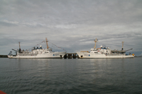
A shipwreck in Kachemak Bay, Alaska, found by a multibeam sonar in 2008.
High resolution (Credit: NOAA)
Ever wonder what the sea floor looks like? Just ask a NOAA hydrographer (an expert who maps and studies the sea floor) and you will learn that it is very similar to a continent — dotted with plains, mountains, and deep canyons.
“The bottom is littered with rocks, reefs, seamounts, and man-made features such as shipwrecks that make up habitat for many plant and animal species,” said NOAA hydrographer and NOAA Corps Ensign Christine Schultz. “If we don’t know precisely what is below the surface, the uncertainty poses a great danger to cargo and passenger vessels cruising above.”
Sea-floor Mapping Technologies
Schultz and a team of NOAA hydrographers spent part of the past summer mapping the sea floor of Kachemak Bay — one of south-central Alaska’s busiest, most ecologically diverse, and visually stunning estuaries. This ocean and coastal mapping project — better known as “Hydropalooza” to residents of nearby Homer, Alaska — used state-of-the-art sonar (SOund Navigation And Ranging) technology to locate sunken ships, sediment, boulders, lost crab pots, and other debris scattered across the bottom of the bay.

A hydrographer studies data collected by multibeam sonar to generate a 3-D image of the Kachemak Bay floor.
High resolution (Credit: NOAA)
Since human eyes cannot see into the ocean as they can through air, NOAA hydrographers rely on sound to look at the bottom. NOAA uses two kinds of echo sounding sonar equipment to map the sea floor: multibeam and side scan. Multibeam sonar measures the depth of the sea floor by analyzing the time it takes for sound waves to travel from a boat to the sea floor and back. Side scan sonar creates an image of the sea floor by analyzing the strength of a return echo over a short period of time and paints a picture.
Before sonar technology existed, early American surveyors used ropes and lead weights to survey our nation’s waterways. It was a time-intensive process that only produced one sounding (or depth measurement) at a time. With sonar, multiple soundings can be produced at once, enabling hydrographic ships to more completely survey an area than ever before.
“The unique geologic features and obstructions found in Kachemak Bay are being used to update NOAA’s nautical charts,” said Commander Doug Baird of the NOAA Survey Vessel Fairweather — one of the two ships that surveyed the bay during Hydropalooza. “The nation’s commercial shipping industry relies on up-to-date NOAA nautical charts to navigate vessels into U.S. ports and waterways.” The data collected by the ships also will be used for habitat characterization and fisheries management in other NOAA offices.
Sea-floor Mapping Efforts
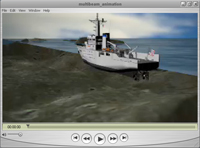
NOAA’s multibeam sonar sends sound beams to the sea floor to measure depths. [MOV]
Download as Quicktime (Credit: NOAA)
Another critical mapping effort took place in the Chukchi Sea, an ice-covered region of the Arctic where hydrographers and scientists need more data about the sea floor. A team of scientists from NOAA and the University of New Hampshire recently led an expedition on board the U.S. Coast Guard icebreaker Healy to collect data to better understand sea floor processes, fish habitat mapping, and climate and circulations models. NOAA also funded U.S. participation in a joint U.S.-Canadian Arctic sea-floor mapping expedition Sept. 6 to Oct. 1.
"State-of-the-art technology like sonar enables NOAA to map the depths of our oceans and helps us understand and protect the marine environment,” said Capt. Steven Barnum, director of NOAA’s Office of Coast Survey and U.S. National Hydrographer.