| NOAA Magazine || NOAA Home Page |
NOAA RESEARCHERS RETRIEVE WEALTH OF DATA AFTER CHASING HURRICANE ISABEL
 Sept.
24, 2003 � As Hurricane Isabel headed for the North Carolina coast,
NOAA researchers continued their pursuit
of observations from both land and air. One valuable weather product
that benefits from data collected during landfalling hurricanes is a
surface wind analysis map known as H*Wind. H*Wind,
created by research meteorologists at the NOAA
Hurricane Research Division, is in transition to operations at the
NOAA National Hurricane Center through the U.S. Weather Research Program.
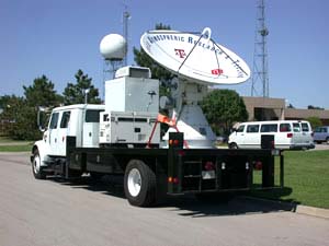
(NOAA image of SMART Radar.)
Sept.
24, 2003 � As Hurricane Isabel headed for the North Carolina coast,
NOAA researchers continued their pursuit
of observations from both land and air. One valuable weather product
that benefits from data collected during landfalling hurricanes is a
surface wind analysis map known as H*Wind. H*Wind,
created by research meteorologists at the NOAA
Hurricane Research Division, is in transition to operations at the
NOAA National Hurricane Center through the U.S. Weather Research Program.
(NOAA image of SMART Radar.)
Data used to create these wind analyses come from many sources, including airborne sensors, offshore monitoring stations and land-based radars and meteorological stations. The data were analyzed every three hours prior to landfall and a brightly colored, easy to read wind analysis was made available to forecasters at the NOAA National Hurricane Center, as well as emergency managers. These wind analyses detail where the most damaging winds in a storm are located, as well as the extent of gale force winds.
 During
Isabel’s landfall, however, a unique
set of data was made available that had a significant impact in
the accuracy of the H*Wind analysis. A series of towers and mobile Doppler
radars were mobilized into key positions to monitor and report on Isabel’s
landfall. Texas Tech University, the University of Oklahoma, and a non-profit
company called the Center for Severe Weather Research, collaborated
to bring five portable Doppler radars and many more portable wind towers
to eastern North Carolina. (Click NOAA image for larger view
of Hurricane Isabel’s maximum and minimum surface wind speeds
taken on Sept. 18, 2003, at 9:30 p.m. EDT. Click
here to see more images. Please credit “NOAA.”)
During
Isabel’s landfall, however, a unique
set of data was made available that had a significant impact in
the accuracy of the H*Wind analysis. A series of towers and mobile Doppler
radars were mobilized into key positions to monitor and report on Isabel’s
landfall. Texas Tech University, the University of Oklahoma, and a non-profit
company called the Center for Severe Weather Research, collaborated
to bring five portable Doppler radars and many more portable wind towers
to eastern North Carolina. (Click NOAA image for larger view
of Hurricane Isabel’s maximum and minimum surface wind speeds
taken on Sept. 18, 2003, at 9:30 p.m. EDT. Click
here to see more images. Please credit “NOAA.”)
Two of the radars, SMART-Radars (Shared Mobile Atmospheric Research and Teaching Radars), are operated jointly by researchers from the NOAA National Severe Storms Laboratory, University of Oklahoma, Texas Tech University and Texas A&M University. These unique instruments are based at NSSL in Norman, Okla.
“This hurricane provided the first opportunity we’ve had to gather data from the entire hurricane using two radars of this type,” said Lou Wicker, NOAA research meteorologist. “The SMART radars are unique in that they were designed to collect data from the entire hurricane, rather than just a piece of it. The data will be used to study the detailed structure of the near-surface winds in the storm as well as how the storm generates a large area of intense rainfall.”
The two mobile 5-cm Doppler radars placed 40 miles apart gathered data in coordination with each other for the first time. Researchers hope the 13 hours of continuous data gathered can provide new information about the severe winds and turbulence associated with hurricanes.
This information, Wicker added, can be used by engineers to improve the structural integrity of buildings, and by meteorologists and hydrologists to improve predictions of the swath of heavy rain and flash floods that often occur within these storms.
The Center for Severe Weather Research, in collaboration with the National Center for Atmospheric Research, brought two Doppler on Wheels and one Rapid Scanning radar. These radars were co-located with one of the instrumented towers to provide additional data for the analysis.
These data greatly complement the standard data available for H*Wind, although typically such information is not available in real-time and is used largely in post landfall research. However, thanks to innovation and careful planning, four additional weather stations built and operated jointly in partnership with Sea Grant at Clemson University and the University of Florida, were able to transmit their meteorological data in real-time via a wireless Internet connection that performed flawlessly.
For the first time ever, detailed coastal tower wind data were transmitted in real-time from the field to the NOAA Hurricane Center in Miami, Fla., during a landfalling hurricane and incorporated into the real-time H*Wind analyses. The four sets of tower observations also provided valuable ground truth for some of the new sensors deployed on NOAA research aircraft flying above the storm.
The analyses are posted online.
Despite the extreme conditions, the Clemson/University of Florida communication system allowed transmission of tower observations into H*Wind every 15 minutes. These high quality observations also constitute the highest wind speed for which continuous, high frequency, digital observations have been recorded in a U. S. landfalling hurricane, and represent a valuable contribution to hurricane research.
The placement of the towers appeared just about optimal with Isabel’s center passing directly between them, with locations in Wilmington, Atlantic Beach, Cape Hatteras, and Elizabeth City in North Carolina. The reliability of these real-time reports just prior to landfall was a tremendous achievement. CMAN stations, permanent monitoring stations located just offshore, were not transmitting data, leaving the tower data as the only wind reports from the coast that were still reporting to the NOAA Hurricane Center. NOAA Hurricane Research Division scientists were able to relay H*Wind reports to NOAA Hurricane Center forecasters and kept them abreast of the rate of wind increase at the coast as Isabel approached. Not only did it make the H*Wind product invaluable to forecasters but it also gave forecasters a sense of how quickly conditions on the coast were deteriorating.
The efforts of the tower crews were a shining example of how research projects can make a valuable contribution to operational forecasting and community preparations while at the same time gather a research data set that will be studied for years. NOAA scientists hope that in the future such high frequency real-time transmissions at hurricane landfall might also become more commonplace.
NOAA is dedicated to enhancing economic security and national safety through the prediction and research of weather and climate-related events and providing environmental stewardship of the nation�s coastal and marine resources. NOAA is part of the U.S. Department of Commerce.
Relevant Web Sites
NOAA Hurricane Research
Division
NOAA National Severe Storms Laboratory
Florida Coastal Monitoring Program
Media
Contacts:
Keli Tarp, NOAA
Weather Partners, (405) 366-0451 or Erica
Van Coverden, NOAA Hurricane
Research Division, (305) 361-4541