
 Feeds & Data
Magnitude 6.3 - CENTRAL ITALY
2009 April 06 01:32:39 UTC
Earthquake Details
| Magnitude | 6.3 |
|---|---|
| Date-Time |
|
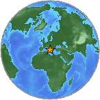
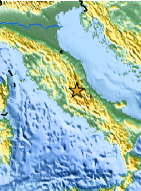
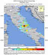
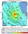
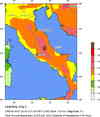
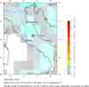
| Location | 42.334°N, 13.334°E |
| Depth | 8.8 km (5.5 miles) set by location program |
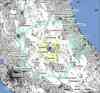
| Region | CENTRAL ITALY |
| Distances | 75 km (45 miles) W of Pescara, Italy 85 km (55 miles) NE of ROME, Italy 115 km (75 miles) SE of Perugia, Italy 145 km (90 miles) S of Ancona, Italy |
| Location Uncertainty | Error estimate not available |
| Parameters | NST=460, Nph=460, Dmin=6 km, Rmss=0 sec, Gp= 14°, M-type=teleseismic moment magnitude (Mw), Version=Q |
| Source |
|
| Event ID | us2009fcaf |
- This event has been reviewed by a seismologist.
- Did you feel it? Report shaking and damage at your location. You can also view a map displaying accumulated data from your report and others.
Earthquake Summary
Felt Reports
At least 287 people killed, 1,000 injured, 40,000 homeless and 10,000 buildings damaged or destroyed in the L'Aquila area. Felt throughout central Italy.
Tectonic Summary
The April 6th 2009 earthquake in Central Italy occurred as a result of normal faulting on a NW-SE oriented structure in the central Apennines, a mountain belt that runs from the Gulf of Taranto in the south to the southern edge of the Po basin in northern Italy. Geologically, the Apennines are largely an accretionary wedge formed as a consequence of subduction. This region is tectonically and geologically complex, involving both subduction of the Adria micro-plate beneath the Apennines from east to west, continental collision between the Eurasia and Africa plates building the Alpine mountain belt further to the north and the opening of the Tyrrhenian basin to the west. The evolution of this system has caused the expression of all different tectonic styles acting at the same time in a broad region surrounding Italy and the central Mediterranean. The April 6th, 2009 earthquake is related to normal faulting and the east-west extensional tectonics that dominate along the entire Apennine belt, primarily a response to the Tyrrhenian basin opening faster than the compression between the Eurasian and African plates.
The central Apennine region has experienced several significant earthquakes in recorded history. In 1997, a significant Mw 6.0 earthquake 85 km north-northwest of the April 6th 2009 event killed 11, injured over 100 and destroyed approximately 80,000 homes in the Marche and Umbria regions. This 1997 event was part of a series of earthquakes known as the Umbria-Marche seismic sequence, which included eight events of magnitude greater than M5.0 in a two-month period between September and November of that year.
Earthquake Information for Europe

Earthquake Maps


Scientific & Technical Information

Additional Information, News Reports
- Preliminary Earthquake Report
- U.S. Geological Survey, National Earthquake Information Center:
World Data Center for Seismology, Denver
