Pollutants in the Environment
Emergency Response
Pollutants in the Environment
Serving Communities
Natural Resource Restoration

Information for:
Emergency Responders
Students and Teachers
Interested Public
Research Institutions
Other Agencies

Current News
Special Note
FAQs

Catalogs of:
Publications
Software & Data Sets
Web Portals
Links
Downloads
Image Galleries
Abandoned Vessels
Drift Card Studies

About OR&R
Contact Us
Advanced Search
Site Index
Privacy Policy
Document Accessibility

Pollutants in the EnvironmentHome | Image Galleries | Pollutants in the Environment

Dogwood Run GPS Locations 13 to 19 - Part 2

Click on an image below to see the full image.

Location 16 - Beaver dam across Little Elk Creek at confluence with Dogwood Run

Location 16 - Beaver dam across Little Elk Creek at confluence with Dogwood Run
(11.30.99, Dogwood Run)

Location 16 - Beaver swimming towards its dam

Location 16 - Beaver swimming towards its dam
(11.30.99, Dogwood Run)

Location 16 - Beaver dam with some trash

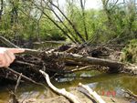
Location 16 - Beaver dam with some trash
(11.30.99, Dogwood Run)

Location 17 - High cut bank on Little Elk Creek with lots of roots for structure

Location 17 - High cut bank on Little Elk Creek with lots of roots for structure
(11.30.99, Dogwood Run)

Location 17 - Looking upstream on Little Elk Creek - gentle flow and cut bank with large woody debris on far bank

Location 17 - Looking upstream on Little Elk Creek - gentle flow and cut bank with large woody debris on far bank
(11.30.99, Dogwood Run)

Location 17 - Looking downstream across pebbly point bar towards beaver dam

Location 17 - Looking downstream across pebbly point bar towards beaver dam
(11.30.99, Dogwood Run)

Location 18 - Beaver-chewed tree

Location 18 - Beaver-chewed tree
(11.30.99, Dogwood Run)

Location 18 - Beaver dam from downstream side

Location 18 - Beaver dam from downstream side
(11.30.99, Dogwood Run)

Related Pages on Our Site
NOAA logo