Pollutants in the Environment
Emergency Response
Pollutants in the Environment
Serving Communities
Natural Resource Restoration

Information for:
Emergency Responders
Students and Teachers
Interested Public
Research Institutions
Other Agencies

Current News
Special Note
FAQs

Catalogs of:
Publications
Software & Data Sets
Web Portals
Links
Downloads
Image Galleries
Abandoned Vessels
Drift Card Studies

About OR&R
Contact Us
Advanced Search
Site Index
Privacy Policy
Document Accessibility

Pollutants in the EnvironmentHome | Image Galleries | Pollutants in the Environment

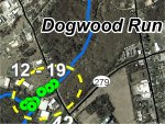
Dogwood Run GPS Location 12

Location 12 is where Dogwood Run crosses under SR 545 (also known as Blue Ball Road).  The team walked under the downstream side of the bridge and noted that concrete had been poured across Dogwood Run to protect several small pipes and conduits.  It appeared that several of the pipes were no longer serviceable; it was unclear whether there were viable utilities buried deeper in the concrete.  The streambed below the utility crossing was down-cut approximately one foot, creating a fish passage barrier.  The water flowing over the crossing was only a few inches deep.  There were large burlap bag-shaped concrete structures lining the left bank under the box culvert; these were apparently intended to protect the bridge abutment.  On the right bank, there were a few bags but several bags appeared to have washed out and were scattered in the streambed below the road crossing.  The riparian zone on the right bank is narrow, 6 to 9 m (20 to 30 feet), and is directly adjacent to the downstream edge of the Triumph Industrial Park.  The Triumph Industrial Park has mowed grass in the area closest to Dogwood Run.

Click on an image below to see the full image.

Location 12 - Aerial View

Location 12 - Aerial View
(11.30.99, Dogwood Run)

Location 12 - Welcome to Elkton sign

Location 12 - Welcome to Elkton sign
(11.30.99, Dogwood Run)

Location 12 - Utility crossing under Dogwood Run at SR 545 that is a potential barrier to fish passage

Location 12 - Utility crossing under Dogwood Run at SR 545 that is a potential barrier to fish passage (1 of 2)
(11.30.99, Dogwood Run)

Location 12 - Looking upstream at Dogwood Run under SR 545 bridge, large concrete bags to protect road abutments, stalactites hanging from bridge deck

Location 12 - Looking upstream at Dogwood Run under SR 545 bridge, large concrete bags to protect road abutments, stalactites hanging from bridge deck
(11.30.99, Dogwood Run)

Location 12 - Utility crossing under Dogwood Run at SR 545 that is a potential barrier to fish passage

Location 12 - Utility crossing under Dogwood Run at SR 545 that is a potential barrier to fish passage (2 of 2)
(11.30.99, Dogwood Run)

Related Pages on Our Site
NOAA logo