Tornado Background
Release Date: February 18, 2003
Release Number: R7-03-06a
» 2003 Region VII News Releases
Tornadoes have struck every U.S. state, including Alaska and Hawaii. But most tornadoes form in a belt from Nebraska southward through Kansas and Oklahoma, into central Texas, known as "Tornado Alley," and in the Southeastern United States. The four states of FEMA Region VII are situated in the heart of "Tornado Alley."
A tornado is defined as a violently rotating column of air extending from the base of a thunderstorm to the ground. Air moves very rapidly upward around a tornado center. This distinguishes tornadoes from microbursts, which often do tornado-like damage and can be mistaken for tornadoes. In contrast to the upward rush of air in a tornado, air blasts rapidly downward from thunderstorms to create microbursts. A typical tornado outbreak often features an intense upper-level disturbance moving across the Plains during spring. This disturbance provides the strong vertical wind shear that gives an updraft its twisting motion, turning a normal thunderstorm into a potentially tornado-spawning supercell.
Severe spring and summer storms frequently spawn killer twisters. Be alert for these warning signs:
- An approaching cloud of debris can mark the location of a tornado even if a funnel is not visible.
- Before a tornado hits, the wind may die down and the air may become very still.
- Tornadoes generally occur near the trailing edge of a thunderstorm. It is not uncommon to see clear, sunlit skies behind a tornado.
Tornado Watches and Warnings
A tornado watch is issued by the National Weather Service when tornadoes are possible in your area. Remain alert for approaching storms. This is time to remind family members where the safest places within your home are located, and listen to the radio or television for further developments.
A tornado warning is issued when a tornado has been sighted or indicated by weather radar.
Tornado strength is measured by the "Fujita Scale." Named after its creator, Tetsuya Theodore Fujita, it categorizes tornado severity based on damage observed, not recorded wind speeds. Wind speeds referred to in this scale are estimates that are intended to represent the observed damage.
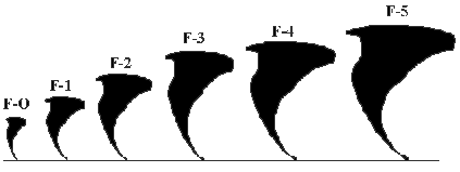
F-0: 40-72 mph, chimney damage, tree branches broken
F-1: 73-112 mph, mobile homes pushed off foundation or overturned
F-2: 113-157 mph, considerable damage, mobile homes demolished, trees uprooted
F-3: 158-205 mph, roofs and walls torn down, trains overturned, cars thrown
F-4: 207-260 mph, well-constructed walls leveled
F-5: 261-318 mph, homes lifted off foundation and carried considerable distances, autos thrown as far as 100 meters
Since 1999, tornadoes have caused damages resulting in presidential disaster declarations every year in Region VII.
DR-1273-KS: The tornadoes of May 3, 1999, in Kansas and Oklahoma, killed 49 people. An F4 tornado struck the town of Haysville, Kansas, southwest of Wichita and the southern portion of the City of Wichita, causing six fatalities. Haysvilles entire historic district was destroyed.
DR-1327-KS: On April 19, 2000, two supercell thunderstorms produced damaging tornadoes in southeastern Kansas. Hardest hit was Parsons, Kansas (population 11,924) where the tornado went through the center of town. Crawford, Labette and Neosho counties were included in the May 3 disaster declaration.
DR-1366-KS: On April 21, 2001, an F-4 tornado cut a path through Hoisington, in Barton County, Kansas, destroying 182 homes, causing major damage to 52 homes, and minor damage to 180 more residences.
DR-1394-NE: In the early evening hours of August 17, 2001, a tornado struck the Village of Jackson, Nebraska. It was on the ground for one mile, destroying several homes, damaging City Hall, and temporarily closing all major roadways due to tree and building debris The communitys only elementary school building, built in 1887, was destroyed.
DR-1412-MO: Between April 24 and 28, 2002, a series of severe storms and tornadoes cut a path through the southern Missouri Ozarks. More storms and flooding continued into May.
Last Modified: Tuesday, 15-May-2007 15:43:18