FEMA Prepares New Study of Annualized Earthquake Losses
FEMA has updated the 2001 landmark study, Annualized Earthquake Losses (FEMA 366), which utilizes HAZUS to compare the earthquake risk across the U.S., and specifically to estimate annualized earthquake loss to the national building stock.
The new study, released in 2006, uses HAZUS-MH MR2 and the 2002 U.S. Geological Survey Probabilistic Hazard Maps (which are based on the latest seismological, geophysical, and geological information) to estimate annualized earthquake loss in the U.S. In addition, the 2006 FEMA Annualized Earthquake Losses (AEL) study addresses three important dimensions of earthquake risk analysis: casualties, debris and shelter.
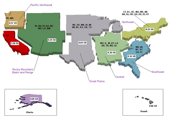
Comparison of U.S. Regional Seismic Risk by Annualized Earthquake Losses (AEL)
Study Findings
The HAZUS-MH analysis indicates that the AEL to the national building stock is $5.3 billion per year.
- The majority (77 percent) of average annual loss is located on the West Coast (California, Oregon, Washington).
- Sixty-six percent ($3.5 billion per year) concentrated in the state of California. The high concentration of loss in California is consistent with the state’s high seismic hazard and large structural exposure.
- Twenty-three percent (1.1 billion per year) of annual loss is distributed throughout the rest of the U.S. (including Alaska and Hawaii), as reflected in the regional map.
While the majority of economic loss is concentrated along the west coast of the United States, the distribution of relative earthquake risk, as measured by the Annualized Earthquake Loss Ratio (AELR), is much broader and reinforces the fact that earthquakes are a national problem. There are relatively high earthquake loss ratios throughout the western U.S., the central U.S. (states within the New Madrid Seismic Zone), and in the Charleston, South Carolina area.
Earthquakes and the Urban Risk
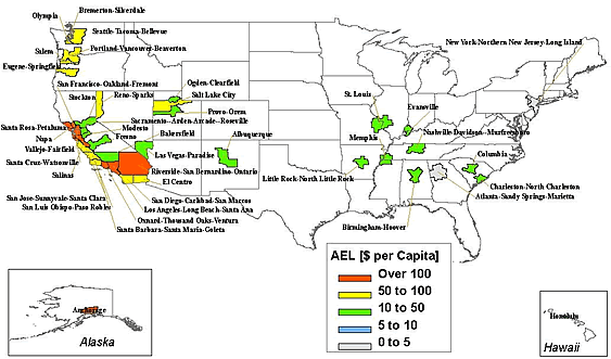
Forty-three metropolitan area, led by the Los Angeles and San Francisco Bay areas, account for 82 percent of the total annualized losses in the U.S. Los Angeles County alone has about 25 percent of the total AEL. Los Angeles and San Francisco Bay area together account for nearly 40 percent of the total AEL. This observation supports the need for strategies to reduce the current seismic risk by focusing on rehabilitation of the existing building stock in our most at risk communities. Strategies to reduce future losses throughout the U.S. need to be closely integrated with policies and programs that guide urban planning and development.
Annualized Earthquake Loss (AEL) Per Capita for Selected Metropolitan Areas
This study addresses three important dimensions of earthquake risk analysis: casualties, debris and shelter. When the data is aggregated by state, California accounts for nearly 50 percent of estimated debris generated, 60 percent of displaced households, and 55 percent of short-term shelter needs.
Applications of the AEL Study Results
This loss study is an important milestone in a long-term, FEMA-led effort to analyze and compare the seismic risk across regions in the U.S. and contributes to the mission of the National Earthquake Hazards Reduction Program (NEHRP) —to develop and promote knowledge and mitigation practices and policies that reduce fatalities, injuries, and economic and other expected losses from earthquakes. The results of this study are useful in at least five ways:
- Improving our understanding of the seismic risk in the U.S.
- Providing a baseline for earthquake policy development and the comparison of mitigation alternatives.
- Supporting the adoption and enforcement of seismic provisions of building codes.
- Comparing the seismic risk with that of other hazards.
- Supporting pre-disaster planning for earthquake response and recovery.
Last Modified: Wednesday, 04-Feb-2009 15:00:44 EST