HAZUS-MH Riverine Flood Model Validation Study
FEMA recently released a validation study of the HAZUS-MH riverine flood loss model, based on a flood event that occurred in St. George, Utah, on January 9-11, 2005. The event provided an opportunity to assess if the HAZUS riverine flood model can predict reasonable losses when compared to a real event.The key findings and conclusions from the study:
-
Flood boundaries modeled by HAZUS-MH generally estimate actual flood boundaries quite well. However, the estimate of flood boundaries and depth grids are highly dependent on the resolution of the digital terrain data.
View Flood Extent Comparison – North (JPG 225k)
View Flood Extent Comparison – South (JPG 214k)
-
HAZUS-MH cannot accurately model floods that occur in narrow canyons as demonstrated by the overestimation of the modeled flood boundary along the Virgin River upstream of the confluence with the Santa Clara River.
-
Along the Santa Clara River, the HAZUS-MH flood extent elevations are comparable with actual flood extend elevations and appear to be in better agreement with the actual flood surface than the 100-year base flood elevations (BFEs) effective at the time of the flood. It is important to acknowledge that HAZUS-MH losses are only estimates, so particular categories will vary from true losses, especially when looking at an individual site with only Level 1 data.
-
HAZUS-MH residential losses along the short reaches of flooded rivers
are comparable with true residential losses.
-
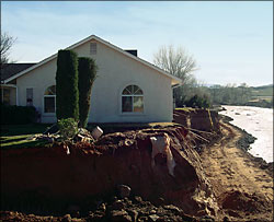
Building losses due to erosion require editing of the default depth-damage curves in HAZUS-MH to represent significant losses from relatively shallow flood events. The photo, below, is an example of a structure damaged by bank erosion during the flood on the Santa Clara.
-
Average percent building loss ratios generated by HAZUS-MH are comparable to those using actual assessor’s market value data. Comparisons of loss ratios help remove uncertainty caused by different building valuation methodologies.
-
Total HAZUS-MH residential losses are approximately 30 percent higher than the total assessed residential losses. Comparing total losses for a study reach is more accurate than comparing total losses at individual census blocks.
-
The study authors concluded that HAZUS-MH is a useful tool for modeling flood boundaries and in estimating economic and social losses. Provided accurate event flow discharges are available through accurate forecasting, at gages or other known locations along the reach of interest, HAZUS-MH can help provide timely flood boundary and loss estimate information before, during, and after a flood. View the entire study to HAZUS-MH Riverine Flood Model Validation Study.
Download the handout version of this story.
Last Modified: Tuesday, 23-Oct-2007 10:51:42 EDT