Hurricane Katrina Flood Recovery Maps (Louisiana)
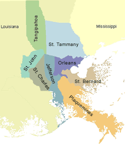
Maps showing the extent and magnitude of Hurricane Katrina’s surge, as well as information on advisory flood data, were created for areas in southeastern Louisiana parishes that were most severely impacted by coastal flooding. These maps show high water marks surveyed after the storm, an inundation limit developed from these surveyed points, and FEMA’s Advisory Base Flood Elevations (ABFEs). To access the Katrina Recovery Maps for each Louisiana parish, click on the links below or on the map above.
- Jefferson Parish
- Orleans Parish
- Plaquemines Parish
- St. Bernard Parish
- St. Charles Parish
- St. John the Baptist Parish
- St. Tammany Parish
- Tangipahoa Parish
- Rita Recovery Map Parishes
Please check this website periodically for updates.
Katrina Recovery Maps are for advisory purposes only; they do not supersede effective Flood Insurance Rate Maps (FIRMs) for insurance rating purposes. The Hurricane Katrina-related data presented are preliminary and subject to update as additional data become available.
In addition, FEMA has produced index maps for each parish. These maps show the detailed Katrina Recovery Map paneling scheme, the Hurricane Katrina preliminary High Water Mark (HWM) locations, the Katrina surge inundation limit, and other basic map information (e.g., roads, corporate limits) to help map users locate recovery maps for particular areas of interest. The index map for each parish can be found on its respective mapping home page, which can be accessed through the links above.
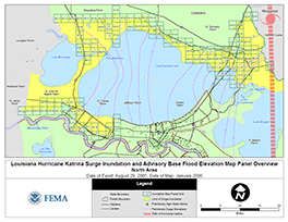 FEMA has also produced the first of several regional overview maps concerning the parishes impacted by Hurricane Katrina. This first map (PDF 0.8 MB) covers the first parishes for which detailed Katrina Recovery Maps were published: St. Tammany, Tangipahoa, St. John the Baptist (north of the Mississippi River), and St. Charles (north of the Mississippi River). The overview map shows the paneling scheme for the recovery maps, the Hurricane Katrina preliminary HWM locations, the Katrina surge inundation limit, and Katrina storm surge elevation contours. The latter feature is based on an assessment of the general surge trends interpreted from the surveyed HWMs, engineering judgment concerning general surge behavior in coastal areas, and a comparison against numerical surge forecasts (e.g., SLOSH model runs) prepared by the National Oceanic and Atmospheric Administration’s Tropical Prediction Center.
For information regarding Mississippi, please visit the Mississippi costal mapping project web site or the site's contract page.
For inquiries concerning Louisiana, please visit the Louisiana coastal mapping project web site or e-mail the helpline at: info@lamappingproject.com.
Download Plug-in
Some of the links on this page require a plug-in to view them. Links to the plug-ins are available below.
Last Modified: Monday, 24-Sep-2007 17:09:37 EDT