|
|


|
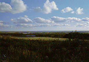
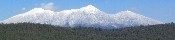
Why are clouds sometimes round and fluffy on top, and smooth and flat underneath?
Clouds and fog form when the temperature of the air reaches the condensation point, which is
the point at which water vapor (which is an invisible gas) becomes a liquid. When it reaches
this point, the liquid collects on the dust particles in the air and become visible.
We call the results clouds, unless the clouds form at the ground surface, in which case we call it fog.
Various factors influence the exact point at which condensation can occur, such as the air pressure
at a given altitude, the moisture content of the air, and the air temperature. In most cases, air temperature
is the most important factor.
As we know, temperature typically doesn't vary dramatically in the horizontal, but temperature
does vary with height. In fact, temperature typically decreases with height, as can be found when climbing a mountain.
This fact means that the condensation point is also horizontally uniform at a given altitude. Above this
altitude, water vapor will condense out to form clouds, below it water will remain in its gaseous state. Therefore,
because the point at which condensation occurs tends to be about as uniform as surface temperature, the bottoms of
most clouds will appear flat.
Even though the condensation point tends to be at a constant altitude, the cloud will continue to grow
vertically after condensation. How high it will grow depends again on the three factors discussed above. However,
as the cloud grows vertically, it will draw in drier air from the surrounding atmosphere. The cloud will then
start to evaporate along the edges and erode, leading to the "fluffy" look.
Not all clouds, however, have a rounded, fluffy appearance on top. Those that do are called cumulus clouds.
They are formed as warm, moist air rises and cools to the condensation point. The air stops rising
when it cools to the temperature of the surrounding air in the atmosphere. In contrast, stratus clouds form when the
ambient temperature of the air reaches the condensation point by being forced aloft, such as over a warm frontal boundary.
There is little vertical motion of the air, so the clouds form in place and have a flat bottom AND top.
Both types have "flat" bottoms though, formed through the process discussed above.
|
|
|
Webmaster
US Dept of Commerce
National Oceanic and Atmospheric Administration
National Weather Service
Flagstaff Weather Forecast Office
P.O. Box 16057
Bellemont, AZ 86015-6057
http://weather.gov/flagstaff
Tel: (928) 556-9161
|
Disclaimer
Information Quality
Credits
Glossary |
Privacy Policy
Freedom of Information Act
About Us
Career Opportunities
|
National Weather Service Mission: "The
National Weather Service (NWS) provides weather,
hydrologic, and climate forecasts and warnings for
the United States, its territories, adjacent waters
and ocean areas, for the protection of life and
property and the enhancement of the national economy.
NWS data and products form a national information
database and infrastructure which can be used by
other governmental agencies, the private sector,
the public, and the global community." |
|
|