
NOAA: U.S. Drought Shows Signs of Improvement
September 18, 2008

High resolution (Credit: NOAA)
The latest U.S. Drought Monitor shows improvement in drought conditions over the Plains and the Midwest, in part due to landfalling tropical systems, and also shows lingering drought for the interior Southeast, south-central Texas, and California. And as of September 16, the contiguous U.S. has the lowest coverage of all levels of drought (21.9 percent), including severe drought (7.5 percent), since January 2006.
“U.S. drought coverage has decreased from nearly 30 percent between mid-June and early August to about 20 percent now,” said Douglas Le Comte, drought specialist at NOAA’s Climate Prediction Center. “During the past 12 weeks there has been a pronounced reduction in extreme to exceptional drought in many areas of the country.”
Heavy rain associated with the Southwest and Florida rainy seasons along with tropical storms have had a significant impact. June through August precipitation across the contiguous United States averaged 9.05 inches, 0.8 inch above the 1901–2000 average, making this the 15th wettest summer since 1895.
Of all the tropical cyclones, Tropical Storm Fay had the greatest impact on U.S. drought. In August, Fay dropped more than five inches of rain on parched sections of Georgia, Alabama, Mississippi, Tennessee, and North and South Carolina. While Fay’s rains eased drought in the southern Appalachians, more rain is needed to erase drought conditions stemming from rainfall deficits exceeding 20 inches over two years. Hurricane Gustav ended drought in Louisiana, while Tropical Storm Hanna eliminated drought over central North Carolina and south-central Virginia, but its track failed to provide relief for the western Carolinas.
Multiple storms – Hurricane Dolly (July), Hurricane Edouard (August), and Hurricane Ike (September) – greatly minimized much of the drought in coastal Texas. However, the rains from these storms largely missed the drought over south-central Texas.
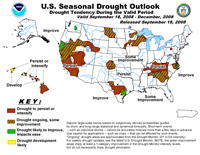
High resolution (Credit: NOAA)
The U.S. Seasonal Drought Outlook, also updated today, shows improvement may be more limited into early winter over the interior Southeast, with drought forecast to persist in Kentucky, Tennessee, and western North Carolina. Some improvement is expected farther south and east. Lower temperatures and less water use across the region mean that reservoirs and wells should begin to revive by late autumn 2008. In Texas, lingering drought is predicted to persist in south-central areas but improve near the coast. On the West Coast, where drought impacts have worsened over the summer, Pacific storms should begin to ease drought over northern California, while little change is expected over southern California through early winter.
The next U.S. Drought Monitor will be published on September 25 and the U.S. Seasonal Drought Outlook will be on October 16.
NOAA understands and predicts changes in the Earth's environment, from the depths of the ocean to the surface of the sun, and conserves and manages our coastal and marine resources.