|
|
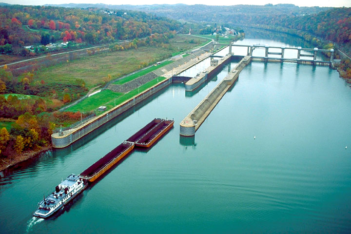
Maxwell Locks and Dam
142 Maxwell Locks and Dam
E. Millsboro, PA 15433-1261
724-785-5027
|
| |
|
Maxwell Locks and Dam is one of nine navigation structures
which provide for year-round navigation on the Monongahela River
between Pittsburgh, PA and Fairmont, West Virginia. It maintains a
pool for 20.8 miles upstream to Grays Landing Lock and Dam near Grays
Landing, PA
Location
Maxwell Locks and Dam is located at river mile 61.2 approximately
5 miles south of Brownsville, PA The lock chambers and operations
buildings are situated along the right bank of the river. Road access
to the project is from a local legislative route south of Brownsville.
History
Construction of Maxwell Locks and Dam began in 1960 and was completed
in 1965. The construction of this facility resulted in the removal
of old Lock and Dam 6 at Rices Landing, PA
Project
Information
Maxwell Locks and Dam consists of two lock chambers and a gated
dam. This type of dam is constructed to permit increased control
over the water level in the navigation pool upriver of the dam.
Machinery mounted on tall concrete piers moves large chains which
lift gates that are hinged into the body of the piers. As the gates
are raised or lowered to control the amount of water flowing under
them, the upstream pool is maintained at a relatively constant level
for an authorized depth of at least 9 feet throughout its length.
The dam, however, cannot be operated to control flood flows. An
incidental benefit derived from the pool formed by the dam is the
availability of a source of municipal and industrial water.
|