| U.S. Department of Agriculture National Agricultural Statistics Service Research and Development Division |
| U.S. Department of Agriculture National Agricultural Statistics Service Research and Development Division |
|
of the Director |
|
|
|
Animated Maps
(requires QuickTime) 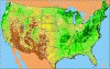 Soybeans | Wheat More Links Data Lab (Special Tabulations) Map Maker: nationalatlas.gov USDA | NASS |
Research Highlights
Spatial Data - Vegetation Condition Images - Cropland Data Layer Image Gallery (2003) available for these states: Arkansas, Illinois, Indiana, Iowa, N. Dakota, Mississippi, Missouri, Nebraska, Wisconsin) - Land Use Strata for Selected States - Interact with Data (1997) - 2002 Maps: Gallery | Star Tree | List - "Linked Micromap" Plots (1997): Corn | Cotton | Hay | Soybeans | Wheat - Research Reports - Remotely Sensed Data |
2002 Census Maps
Map Gallery  StarTree (requires Java) 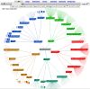 |
