MYST2 : Pat Mayse Lake
Current Readings:
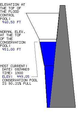
- Pool elevation is 449.05 feet on Thursday 08Jan09 Time: 1900 hours.
- At this elevation the total amount of water stored in Pat Mayse Lake is 106878 acre-feet.
- Reservoir release is 0 cubic feet per second on Thursday 08Jan09 Time: 1800 hours.
- Conservation pool is 90.21% full.
- Conservation storage filled is 103468 acre-feet which is equivalent to 11.09 inches of runoff over the entire drainage basin.
- Conservation storage empty is 11231 acre-feet which is equivalent to 1.20 inches of runoff over the entire drainage basin.
Gate Changes:
- No Gate Changes have been made in the last 4 days.
Reservoir Data:
|
Elevation |
Incremental Storage |
Cumulative Storage |
|
(feet) |
(inches) |
(acre-feet) |
(inches) |
(acre-feet) |
| Surcharge Pool: |
---- |
---- |
---- |
---- |
---- |
| Flood Control Pool: |
460.50 |
6.95 |
64833 |
19.60 |
182942 |
| Conservation Pool: |
451.00 |
12.29 |
114699 |
12.65 |
118109 |
| Inactive Pool: |
415.00 |
0.37 |
3410 |
0.37 |
3410 |
Streambed Elevation: 392.50 feet.
Top of Dam Elevation: 488.50 feet.
All storages based on a contributing drainage area of 175 square miles.
Total drainage area for the lake is 175 square miles (including upstream projects).
Longitude: 95° 32' 38" Latitude: 33° 51' 10"
Links for More Information:
Graphs of Measured and Calculated Lake Parameters:
Click on a thumbnail to receive the full-size graphic.
| Elevation |
Releases |
Inflow |
Precipitation |
 |
 |
 |
 |