HEYO2 : Heyburn Lake

Current Readings:
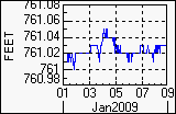
- Pool elevation is 761.02 feet on Thursday 08Jan09 Time: 1900 hours.
- At this elevation the total amount of water stored in Heyburn Lake is 5013 acre-feet.
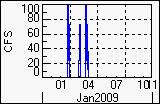
- Reservoir release is 0 cubic feet per second on Thursday 08Jan09 Time: 1800 hours.
- Conservation pool is 84.58% full.
- Conservation storage filled is 2672 acre-feet which is equivalent to 0.41 inches of runoff over the entire drainage basin.
- Conservation storage empty is 487 acre-feet which is equivalent to 0.07 inches of runoff over the entire drainage basin.
Gate Changes:
- No Gate Changes have been made in the last 4 days.
Reservoir Data:
|
Elevation |
Incremental Storage |
Cumulative Storage |
|
(feet) |
(inches) |
(acre-feet) |
(inches) |
(acre-feet) |
| Surcharge Pool: |
---- |
---- |
---- |
---- |
---- |
| Flood Control Pool: |
784.00 |
7.74 |
50803 |
8.58 |
56303 |
| Conservation Pool: |
761.50 |
0.48 |
3159 |
0.84 |
5501 |
| Inactive Pool: |
755.50 |
0.36 |
2342 |
0.36 |
2342 |
Streambed Elevation: 718.00 feet.
Top of Dam Elevation: 807.00 feet.
All storages based on a contributing drainage area of 123 square miles.
Total drainage area for the lake is 123 square miles (including upstream projects).
Longitude: 96° 17' 55" Latitude: 35° 56' 52"
Links for More Information:
Graphs of Measured and Calculated Lake Parameters:
Click on a thumbnail to receive the full-size graphic.
| Elevation |
Releases |
Inflow |
Precipitation |
 |
 |
 |
 |