DSNT2 : Lake Texoma, Denison Dam

Current Readings:
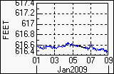
- Pool elevation is 616.49 feet on Thursday 08Jan09 Time: 1900 hours.
- At this elevation the total amount of water stored in Lake Texoma, Denison Dam is 2478657 acre-feet.
- Reservoir release is 19 cubic feet per second on Wednesday 07Jan09 Time: 2400 hours.
- Conservation pool is 98.92% full.
- Conservation storage filled is 1429708 acre-feet which is equivalent to 0.79 inches of runoff over the entire drainage basin.
- Conservation storage empty is 15622 acre-feet which is equivalent to 0.01 inches of runoff over the entire drainage basin.
Gate Changes:
- No Gate Changes have been made in the last 4 days.
Reservoir Data:
|
Elevation |
Incremental Storage |
Cumulative Storage |
|
(feet) |
(inches) |
(acre-feet) |
(inches) |
(acre-feet) |
| Surcharge Pool: |
---- |
---- |
---- |
---- |
---- |
| Flood Control Pool: |
640.00 |
1.42 |
2566784 |
2.81 |
5061062 |
| Conservation Pool: |
* 616.70 |
0.80 |
1445330 |
1.38 |
2494279 |
| Inactive Pool: |
590.00 |
0.58 |
1048949 |
0.58 |
1048949 |
Streambed Elevation: 505.00 feet.
Top of Dam Elevation: 670.00 feet.
* Project has seasonal conservation pool.
All storages based on a contributing drainage area of 33783 square miles.
Total drainage area for the lake is 39719 square miles (including upstream projects).
Longitude: 96° 34' 20" Latitude: 33° 49' 5"
Links for More Information:
Graphs of Measured and Calculated Lake Parameters:
Click on a thumbnail to receive the full-size graphic.
| Elevation |
Releases |
Inflow |
Precipitation |
 |
 |
 |
 |