
Congo, Republic of
August 2008
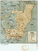
Congo, Republic of, 1990
Enlarge
The Republic of Congo covers a land area of 42,000 sq. km (132,000 sq. mi.); slightly larger than New Mexico. Located in central west Africa, the country lies half above the equator; half below the Equator and is bordered by the Central African Republic, Cameroon, Gabon and the Democratic Republic of the Congo. The population of Republic is 3,800,610 (July 2007 est.) and is made up of 15 principal Bantu groups with more than 70 subgroups. Also present is a small population (less than 100,000) of Pygmies, ethnically unrelated to the Bantu majority. Congo's sparse population is concentrated in the southwestern portion of the country, leaving the vast areas of tropical jungle in the north virtually uninhabited. Thus, Congo is one of the most urbanized countries in Africa, with 70% of its total population living in Brazzaville, Pointe-Noire, or along the 332-mile railway that connects them.
The terrain consists of coastal plains, fertile valleys, central plateau, and forested flood plains and the climate is tropical.
Upon independence in 1960, the former French region of Middle Congo became the Republic of the Congo. A quarter century of experimentation with Marxism was abandoned in 1990 and a democratically elected government took office in 1992. A brief civil war in 1997 restored former Marxist President Denis Sassou-Nguesso, and ushered in a period of ethnic and political unrest. Southern-based rebel groups agreed to a final peace accord in March 2003, but the calm is tenuous and refugees continue to present a humanitarian crisis. The Republic of Congo was once one of Africa's largest petroleum producers, but with declining production it will need new offshore oil finds to sustain its oil earnings over the long term.
CIA World Factbook; State Department Background Notes, 7/2008, 5/2008