 |
Archive for the ‘Risk Assessment’ Category
Thursday, January 22nd, 2009
In January of 1994, the Northridge area of California was shaken by a level 6.7 earthquake, which devastated the area, including California State University at Northridge. See Susan Curzon’s story of the destruction of her library at CSU, and how they responded by getting services back up and running in temporary shelters and with limited staffing. (This story and more are available from the “Library Disaster Stories” page here on the toolkit.)
 Earthquake damage to the rear side of the Oviatt Library. Image from Susan Curzon's story. Today, in the “Emergency Preparedness News” section in the left column of the toolkit, you can see a story about the earthquake drill that is scheduled for Stanford University in early February. It is interesting to see how well their preparedness planners have used the lessons learned from previous incidents in their area and have planned the drill to deal with issues they know they will face when the next quake occurs.
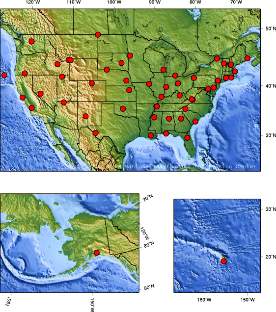
The toolkit has two additional resources for preparedness and risk assessment related specifically to earthquakes. (1) See the “Earthquakes” RSS feed available in the list of RSS feeds on the left, and (2) under “Risk Assessment Maps and Charts” on the right, see the Earthquake map produced by the USGS showing earthquake probability for all of the U.S. The USGS says that over 75 million people live in earthquake-prone zones in the U.S., which affect 39 states.
Posted in Earthquakes, Emergency Preparedness in the News, Featured Web Site, Lessons Learned, Preparedness, Risk Assessment, Toolkit Tips | No Comments »
Monday, January 19th, 2009
Check out the latest new feature of the Toolkit! Scroll down past the Resources section of the right side menu bar to find a list of links to the maps that Dan has used in his training classes on service continuity. The maps are helpful for risk assessment for all regions–they add a larger picture to the very localized knowledge that most of us have about what has happened or is likely to happen in our areas. The maps in the “Risk Assessment Maps & Charts” section cover incidents of severe weather, earthquakes, wildfires, chemical and nuclear power plans, flood plains, tornadoes, among others.

Posted in Disaster Incidents, Earthquakes, Fire, Hazardous Weather Outlook, Risk Assessment, Toolkit Tips | No Comments »
Tuesday, January 13th, 2009
As we know, there are many web sites that provide valuable information about emergency preparedness and response, a case in point being the CDC site which we mentioned earlier. The U.S. Department of Health and Human Services, the “mother ship” of other government sites we have mentioned and linked to the toolkit (CDC, Ready.gov, etc.), is another one. The HHS site gathers together the many federal resources that are available to us, weaving them together by topic, and highlighting some we may have missed in looking at other sites, such as the “Emergency Managers National Situation Update” , which is on the FEMA site. The site covers a tremendous amount of territory, but is organized to make information readily available. There’s a lot there that can help us with risk assessment and other preparedness activities for our libraries and localities.

Posted in Disaster Planning, Featured Web Site, Preparedness, Risk Assessment | No Comments »
Wednesday, July 16th, 2008
On Tuesday, July 15, Dan Wilson presented an overview of service continuity planning to over 70 members of the National Network of Libraries of Medicine (NN/LM). The presentation was hosted by the Middle Atlantic Regional Office of NN/LM and was delivered via Adobe Connect. Topics included are risk assessment, determining core services and resources, strategies for maintaining services from a remote site, and protection of unique resources.
Click here to view the slides from Dan’s presentation.
Posted in Risk Assessment, Service Continuity Planning, Training, Writing a Disaster Plan | No Comments »
Tuesday, July 10th, 2007
Check this out! Did we think that our procedures are fine for shelter-in-place? Take a look at this document from the “Redefining Readiness” work group, authored by some very well-spoken people from the New York Academy of Medicine. Having any procedure is better than none, I suppose, but the questions raised by this document are as good as “lessons learned” before the event happens! Back to the drawing board we go!
Posted in Bioterrorism, Business Continuity Planning, Disaster Incidents, Disaster Planning, Lessons Learned, Pandemics/Epidemics, Preparedness, Risk Assessment, Shelter in Place, Suggested Readings | No Comments »
Thursday, May 17th, 2007
Here is another neat site from the US Geological Survey, listing the largest earthquake on record for each state in the US. You might want to refer to this when doing a risk assessment for your area.
Posted in Earthquakes, Risk Assessment | No Comments »
|
|

 NN/LM EP&R Workshop")


