
 Feeds & Data
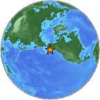
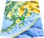
Magnitude MW 5.8 - SOUTHERN ALASKA
2009 January 24 18:09:50 UTC
Earthquake Details
| Magnitude | MW 5.8 |
|---|---|
| Date-Time |
|
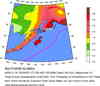
| Location | 59.414°N, 152.836°W |
| Depth | 95.3 km (59.2 miles) set by location program |
| Region | SOUTHERN ALASKA |
| Distances |
|
| Location Uncertainty | Error estimate not available |
| Parameters | NST=070, Nph=081, Dmin=30.9 km, Rmss=0 sec, Gp= 90°, M-type=local magnitude (ML), Version=3 |
| Source | |
| Event ID | ak00088513 |
- This event has been reviewed by a seismologist.
- Did you feel it? Report shaking and damage at your location. You can also view a map displaying accumulated data from your report and others.
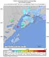
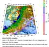
Earthquake Maps

Scientific & Technical Information

- Preliminary Earthquake Report
- Alaska Earthquake Information Center
Geophysical Institute, University of Alaska Fairbanks
