|
| |
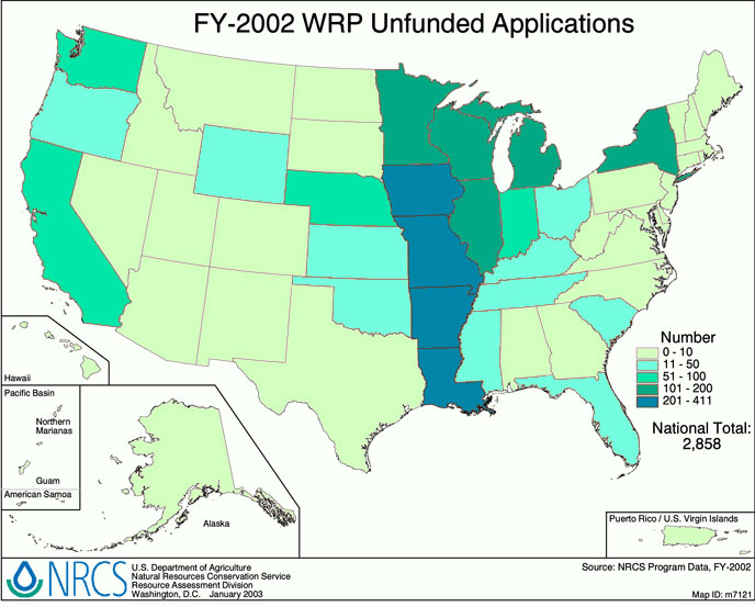
FY-2002 WRP Unfunded Application Information
The following four maps display information on the Wetlands Reserve Program
(WRP) applications for fiscal year 2002 that were not funded.
This voluntary program provides landowners financial incentives and
technical assistance for converting frequently flooded, marginal agricultural
land to its former wetland condition. Through WRP, the Natural Resources
Conservation Service provides technical assistance to landowners to address
wetland, wildlife habitat, water quality, and related natural resource
concerns on their land in an environmentally sound and cost-effective manner.
In FY-2002, NRCS allocated $275 million to enroll nearly 200,000 acres into
the program. Click on each map's data link for detailed information.
Supporting data is available in
Adobe Acrobat format.
Unfunded Applications by Enrollment Type
Click on map to enlarge.
This map shows the percentage of permanent easement, 30-year
easement, and cost-share agreement applications that were not
funded in fiscal year 2002, by State.
 Supporting data by State in tabular format Supporting data by State in tabular format
|
Unfunded Applications (Acres) by Enrollment Type
Click on map to enlarge.
This map show the percentage of acres included in permanent easement,
30-year easement, and cost-share agreement applications that were not
funded in fiscal year 2002, by State.
Supporting data by State in tabular format
|
Program Contact
Tony Puga, National
WRP Manager, 202-720-1062
< Back to Wetlands Reserve Program
| | |