|
Designator |
Office
Name & website |
Phone
Address & Mileage |
MP QuickFind
Database |
||
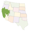
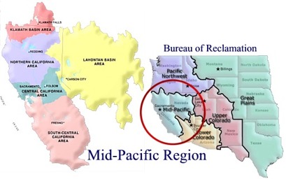
| Mid-Pacific Regional Office | |||||
| Lake Berryessa | |||||
| New Melones | |||||
| Klamath Basin Area Office | |||||
| Lahontan Basin Area Office | |||||
| Northern California Area Office | |||||
| South-Central California Area Office | |||||
| Tracy Field Office | |||||
| Central Valley Operations | |||||
| Mid-Pacific Construction Office | |||||
| Click within the following dropdown list to see the information on each area office | |
The Central California Area Office is headquartered at Folsom Dam, 23 miles east of California’s capital city of Sacramento, with resource offices located at New Melones and Lake Berryessa. The Area Office manages water and land resources in 12 counties, including facilities of the Central Valley Project - American River, Auburn-Folsom South Unit and East Side Divisions, and facilities of the Solano Project. The Office’s jurisdiction extends from the coast to the crest of the Sierra, and from the American River Basin to the Stanislaus River Basin. The Central California Area Office also manages the recreation areas at Lake Berryessa and New Melones reservoir, has a long-term lease with the California Department of Parks and Recreation for Folsom Lake, Lake Natoma and Auburn area, and an agreement with the California Division of Forestry to manage the lands associated with the Auburn Unit. Folsom Dam and reservoir is a major water management facility located within a large metropolitan area. With a capacity of 976,000 acre-feet, the Folsom reservoir catches runoff from the extensive American River watershed and are the key flood control structures protecting the Sacramento metropolitan area. Facilities include:
|
|
Situated in south-central Oregon and northern California, the Klamath Basin Area Office, with headquarters in Klamath Falls, Oregon, was originally authorized as the Klamath Project on May 15, 1905, for irrigation service to about 240,000 acres. Eventually, three storage reservoirs providing 1,104,418 acre-feet of active storage in the Klamath River and Lost River basins were built. More than 1,400 miles of canals and drains, 37 pumping plants, and 2 tunnels provide service to water users, and indirectly to 4 of 6 national wildlife refuges, which are part of the Klamath Basin National Wildlife Refuges Complex. National wildlife refuges are located at Upper Klamath Lake and Clear Lake. Project facilities are operated and maintained by various water districts under joint liability contracts. Several interconnecting facilities and storage reservoirs are maintained by Reclamation and the benefitting entities provide funding for operation and maintenance.
|
|
The Lahontan Basin Area Office, with headquarters in Nevada's capital city of Carson City, covers about 80,000 square miles in northern Nevada and eastern California. The area extends from the Truckee, Carson, and Walker River drainages on the eastern slope of the Sierra Nevada Range to the Great Basin National Park in eastern Nevada and from the Nevada-Oregon border to within 60 miles of Las Vegas. The Newlands Project, formerly the Truckee-Carson Project, was one of the first Reclamation projects dating from 1903. The Lahontan Basin Area Office also manages the Truckee River Storage Project, Washoe Project, and Humboldt Project, involving a variety of issues including municipal water supplies, irrigation, fisheries, endangered species, and tribal Trust concerns.
|
|
The South-Central California Area Office (SCCAO) is responsible for managing land and water resources in the southern half of the Mid-Pacific Region. Generally bordered by the Pacific Ocean to the west, the Sacramento-San Joaquin Delta to the north, the Sierra Nevada Mountains to the east, the Tehachappi Mountains to the southeast, and Santa Barbara and Ventura Counties to the southwest, SCCAO has jurisdiction over approximately 2.5 million acres of irrigated lands, which represents about 25% of the Bureau-wide total. Our customers include about 75 water districts and municipalities, including Westlands Water District (about 600,000 acres), as well as urban areas such as the Silicon Valley, the City of Fresno, and the City of Santa Barbara. Included in SCCAO geographic boundaries is one of the highest producing agricultural areas in the world. More than 200 types of crops are grown in the area, including 45 percent of the Nation's fruits and vegetables. The Delta is the source for water used to irrigate these crops, and is the source of drinking water for 20 million Californians. Delta water is also delivered to state and Federal wildlife refuges in the San Joaquin Valley. Facilities within the SCCAO include over 400 miles of canals, ranging in capacity from 1,000 cubic feet per second to over 13,000 cubic feet per second; the Tracy Pumping Plant; the Tracy Fish Facility; and 15 high-hazard dams. All facilities are operated and maintained by others except the Tracy Fish Facility, Friant and Bradbury Dams. Under the jurisdiction of the SCCAO are facilities of the Delta, Friant, San Felipe, San Joaquin, and West Joaquin Divisions of the Central Valley Project; Cachuma Project; Santa Maria Project; and Ventura River Project.
|
|
| SPECIALIZED OFFICES
|
|
Day-to-day operation of the Central Valley Project is managed by the Central Valley Operations Office in facilities shared by the State Water Project Operations Office, the Flood Operations Branch of the California Department of Water Resources, and the National Oceanic and Atmospheric Administration's National Weather Service. The close proximity is crucial to the coordinated operations of the State's two largest projects. The Central Valley Operations Office does operations forecasting, analyzes reservoir fill potential, channel accretions and depletions, water quality, impact on endangered species, salinity, reservoir levels, in-stream flow, and weather conditions. In addition, the Office assesses the impact of requirements mandated by legislation and other legally binding decisions on Central Valley Project water operations. The Central Valley Operations Office makes the annual allocation of water to irrigation and urban contractors of the Central Valley Project. Power forecasting is done monthly and coordinated with Western Area Power Administration. Generation schedules are also coordinated with Western Area Power Administration as the marketing agency for Central Valley Project power. All major Central Valley Project facilities are monitored and controlled on a real-time basis from the Office's centralized control system. Flood operations are coordinated with the California Department of Water Resources, U. S. Geological Survey, National Weather Service, and the Army Corps of Engineers, which has statutory authority for flood control in all rivers and tributaries. |
|
The MP Construction Office performs design data, pre-construction and on-site construction management, and construction contract administration activities throughout the Mid-Pacific Region. The work includes data gathering, materials investigation and analysis, surveying, constructability reviews, engineering analysis and solution implementation, and project management. Projects include dams, fish screens, pipelines, pumping facilities, storage dams and reservoirs, fish facilities, wildlife mitigation and enhancement, temperature devices, and environmental restoration. The MP Construction Office maintains a cadre of technical competence including the Construction Engineer, Safety and Occupational Health Manager, Contracting Officer, Field Engineering Division including Materials Laboratory and Inspectors, Office Engineering Division, Budget Analyst and full administrative support staff. Located in Willows, California, midway between Sacramento and Redding on Interstate 5, the MP Construction Office establishes satellite field stations to provide oversight contract and laboratory responsibilities at specific sites when necessary. |
|
Bureau of Reclamation, Mid-Pacific Region Public Affairs Office
2800 Cottage Way, Sacramento CA 95825-1898
Main (916) 978-5100 | FAX (916) 978-5114 | TDD (916) 978-5608
Reclamation Officials' Telephone Numbers