April 3, 1974
This page is still under construction..we hope to significantly expand it in the future.
In the meantime, please send us your photos, stories, and memories of April 3, 1974! We'll be happy to post them here.
Click on images for a larger version.
View a slide show that discusses the entire event
Listen to the WHAS-AM broadcast live as it happened in Louisville (mp3 file)
Louisville area
An F4 tornado was born right before the eyes of National Weather Service meteorologists when it touched down north of Standiford Field. The first damage was just west of the fairgrounds. The twister then gathered strength as it tore northeast across the fairgrounds, Cherokee Park, Northfield, and on into Oldham County. Damage was worst in Northfield, where it briefly attained F4 status.
Click on the image below for a map of the Louisville tornado path, as constructed by Dr. Ted Fujita:

This photo was taken in Northfield by meteorologist Russ Conger, who was on shift taking the official weather observations at the NWS weather office when the tornado formed.

Madison, Indiana
Witness Doug Duell shared many pictures with the NWS -- thank you, Doug!
Richmond, Kentucky
This F4 tornado touched down in Garrard County, tore across northwest Madison County, and finally lifted in Clark County. Despite remaining in rural areas it still took seven lives and injured 28 people. Thirty homes were destroyed.
These photos were taken from Commonwealth Hall on the campus of Eastern Kentucky University. The tornado was about nine miles away from the photographer. Photos donated by Mike Schwendeman
 |
 |
 |
Elk Horn, Kentucky
A half-mile wide F4 tornado began in Green County roughly midway between Greensburg and Gresham, and proceeded to the northeast across almost the entire length of Taylor County. The tornado hit Mannsville squarely, where 40 buildings were destroyed and seven were leveled flat to the ground. Thankfully, no deaths occurred, but there were 56 injuries.
These photos were taken by Willard Wise about a mile west of of Elk Horn, Kentucky in Taylor County.
 |
 |
 |
 |
| Facing southwest, with the tornado near Green River Lake State Park. | Facing south, with the tornado near Atchison just north of Green River Lake, possibly crossing Smith Ridge Road about this time. | Facing east, with the twister near the intersection of KY 76 and Speck Ridge Road. | Facing east, with the vortices swirling through the Speck Ridge Road and Parker Road areas, in the vicinity of White's Ridge. |
See the actual weather observation forms taken by the weather employees who witnessed that day's wild weather:
 |
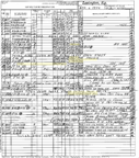 |
 |
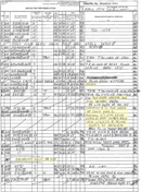 |
| Fort Knox | Lexington | Louisville, Bowman Field | Louisville, Standiford Field |
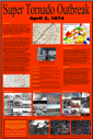
See an 11"x17" version of our commemorative poster (3.7Mb):
Stories