Wind Chill
Click here for a Wind Chill Calculator and Chart.
The NWS implemented a new Wind Chill Temperature (WCT) index in late 2001. The reason for the change was to improve upon the old WCT Index used by the NWS and the Meteorological Services of Canada (MSC, the Canadian equivalent of the NWS), which was based on the 1945 Siple and Passel Index. During the fall of 2000, the Office of the Federal Coordinator for Meteorological Services and Supporting Research (OFCM) formed a special group consisting of several Federal agencies, MSC, the academic research community (Indiana University-Purdue University in Indianapolis (IUPUI), University of Delaware, and University of Missouri), and the International Society of Biometeorology to evaluate the existing wind chill formula and make necessary changes to improve upon it. The group is called the Joint Action Group for temperature Indices (JAG/TI) and is chaired by the NWS. The goal of JAG/TI was to internationally upgrade and standardize the index for temperature extremes (e.g., Wind Chill Index).
The
JAG/TI reached agreement on a new wind chill formula,
discussed a process for scientific verification of the new
formula, and developed plans for implementation of the new
formula. The new WCT index was presented at the JAG/TI
meeting in Toronto, Canada on August 2, 2001.
The JAG/TI formula uses advances in science,
technology, and computer modeling to provide a more
accurate, understandable, and useful formula for calculating
the dangers from winter winds and freezing temperatures.
In addition, clinical trials were conducted and the results
of those trials were used to verify and improve the
accuracy of the new formula.
Standardization of the WCT Index among the meteorological
community was important, so that an accurate and consistent
measure is provided and public safety was ensured.
Specifically, the new WCT index will:
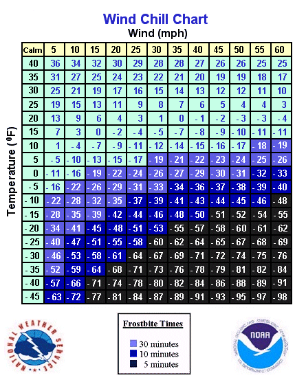
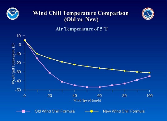
For example, assuming an air temperature of 5 degrees and a wind of 30 mph... Old WCT = -41 New WCT = -18
National Weather Service Forecast Offices have adjusted the threshold values of
Wind Chill Temperatures that trigger Wind Chill Advisories and Wind Chill
Warnings, to reflect the new formula.
Here's the formula:
Wind Chill (F) = 35.74 + 0.6215T - 35.75(V0.16) + 0.4275T(V0.16)
Where V = the wind speed value in mph and
T = the temperature in �F
Note: Frostbite occurs in 30 minutes or less at wind chill values of -18 or lower