|
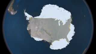
Antarctica is the highest, driest, coldest, windiest and brightest of the seven continents. It is roughly the size of the United States and Mexico combined and is almost completely covered by a layer of ice that averages more than one mile in thickness, but is nearly three miles thick in places. This ice accumulated over millions of years through snowfall. Presently, the Antarctic ice sheet contains 90% of the ice on Earth and would raise sea levels worldwide by over 200 feet were it to melt. The total surface area is about 14.2 million sq km (about 5.5 million sq mls) in summer, much larger then the continental United States, approximately twice the size of Australia, and fifty times the size of the UK. In this still image, Antarctica is shown using the Landsat Image Mosaic of Antarctica (LIMA) data with the continental United States overlaid on top for size comparison. The Landsat Image Mosaic of Antarctica (LIMA) is a data product funded by the National Science Foundation (NSF) and jointly produced by the U.S. Geological Survey (USGS), the British Antarctic Survey (BAS), and the National Aeronautics and Space Administration (NASA). The LIMA data shown here uses the pan-chromatic band and has a resolution of 15 meters per pixel. The 13 swaths used to generate this sample mosaic where acquired between December 25, 1999 and December 31, 2001. The elevation data shown has no vertical exaggeration (1x) and is courtesy of the Radarsat Antarctic Mapping Project (RAMP) Digital Elevation Model (DEM).
|

