|
ARD GIS Tools (DRAFT)
GIS Tools represents a collection of scripts and extensions used by the ARD GIS Team and our Partners. These tools were either developed by ARD or collected by ARD for use in Watershed Database and Mapping Projects.
These tools aid in analysis and mapping spatial data by simplifying or automating tasks and providing functionality to accomplish complex tasks. These GIS scripts and extensions include:
- Import, projection and symbolizing ARD Query Manager Data
- Facilitating the use of OR&R Environmental Sensitivity Index (ESI) data
- Calculating Area/Length/Perimeter
- Labeling multiple co-located points (Cores)
- Image catalog (boundaries) creation
- Adding X/Y coordinates to a table
- Import hazardous material potential footprint ouput from OR&R ALOHA software
- Import NOAA raster charts and ENC's
- Creation of metadata files
Most of these GIS Tools are written for either ArcView 3.x or ArcGIS 9.x. Some tools, such as Query Manager Import Utility are written for use in both ArcView 3.x and ArcGIS 9.x. ArcGIS 9.x tools will be the focus of ongoing development for NOAA ARD.
ARD ArcGIS 9.x • top
NOAA ARD is developing GIS Tools for ArcGIS 9.x to aid in analysis and mapping. Our Division (and Office) continues to use some of the broad range of ArcView 3.x tools developed by us and others; however we are transitioning to ArcGIS 9.x and have developed tools that we have found useful or that are not available.
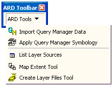
The ARD GIS Toolbar contains a collection of GIS tools developed by NOAA ARD for use in spatial analysis and mapping in ArcGIS 9.x. This toolbar and the commands are written in VB6 and distributed as a dll (dynamic link library) that can easily be added to an ArcMap 9.x project.
CPRD ArcView 3.x • top
The CPRD GIS Tools are a collection of GIS tools created for ArcView 3.X assist development and analysis of spatial data. Some tools are specialized for use with data and functions within CPRD products and Query Manager output; however, most of the tools can be used with any GIS data.
Additional Tools • top
This list is a collection of tools that ARD finds useful in their GIS projects. These tools are not an endorsement of a particular agency or office and by listing these tools ARD is not responsible for results or consequences of user application.
Downloads
|
- ARD GIS Toolbar for ArcView 9.x Download the Toolbar, which includes Query Manager Import, for ArcView 9.x.
(This ActiveX dll file will download as a compressed file.)
(Software format: Zip, size: 90.7 K)
|
- CPRD GIS Tool Box Download the Toolbox extension for ArcView 3.x.
(This ArcView 3.x Extension will download as a compressed file.)
(Software format: Zip, size: 55.1 K)
|
|
|
|