|
|
|
April 2006 Feature: Protecting Corals...Saving ShipsBy displaying the location of coral reefs along with the electronic navigational charts that are being increasingly used by mariners, NOAA’s Office of Coast Survey Protecting Corals, Saving Ships project will soon provide an improved means to protect delicate coral reef ecosystems from physical destruction and pollution caused by passing ships.
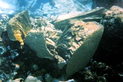
The economic and environmental benefits of coral reefs are estimated at $375 billion a year in the Caribbean-Gulf of Mexico region alone. Each year, ships running aground or anchoring on coral reefs can cause extensive damage to these delicate ecosystems. Such mishaps not only damage the reefs, but also adversely impact the tourism industry and communities that depend on coral reef sustainability for their livelihoods. Maritime accidents are also costly to the shipping industry. Between 1994 and 1997, the financial costs of coral reef groundings to ship owners and insurers in the Caribbean-Gulf of Mexico region exceeded $16 million. These accidents could have been avoided if mariners had the information to plan voyages around the location of sensitive marine habitats and were alerted if they veered too close to these areas. What are Electronic Navigational Charts?An electronic navigational chart (ENC) is a digital file that contains all the chart information necessary for safe navigation, as well as supplementary information required to plan voyages and avoid groundings. NOAA is the official producer of ENCs for the United States, and supplies collected data to mariners, who in turn use it in electronic charting systems that are installed on the bridge of a ship. The International Hydrographic Organization has established minimal information standards for what should be contained in an ENC. This includes features such as shoreline shapes, depths, and hazards to navigation. In addition, so-called Marine Information Objects (MIOs) can be used to supplement the minimum information contained in an ENC. Currently, MIOs have been developed for features such as ice coverage and oceanographic and weather information. No standards, however, have been developed to depict marine habitats such as coral reefs and marine protected areas (MPAs) on ENCs. Thus, the information needed to avoid damaging a coral reef is not readily available to mariners. Displaying Marine Habitats with ENCs
To provide mariners with information on coral reefs, MPAs, and other environmental features, NOAA’s Office of Coast Survey (OCS) has initiated the Protecting Corals, Saving Ships project. The project, which is funded through NOAA’s Coral Reef Conservation Program, will convert existing geographic information systems (GIS) data on coral reefs, MPAs, and other marine habitats into an MIO format for use with ENCs. This information will describe different coral reef and marine habitats as well as any criteria related to regulatory activities in these areas. The Coral Reef MIOs will enable mariners to display the locations of coral reefs and other sensitive marine habitats in conjunction with existing electronic chart information. When a NOAA ENC and Coral Reef MIO are displayed together on an electronic chart system, a vessel will be able to detect coral reefs and protected marine habitats in advance and plan travel routes to avoid crossing these sensitive areas. Shipboard electronic chart systems will also be able to display warnings and regulations that pertain to protected areas, and can sound alarms if a vessel’s projected course swerves too close to a coral reef or an MPA. Automation and integration of these vital tools can help to reduce human error and prevent future coral reef ship groundings. Florida Keys National Marine Sanctuary: A PilotCurrently, OCS is conducting a pilot project in the Florida Keys National Marine Sanctuary (FKNMS). The FKNMS occupies over 3,000 square nautical miles and extends from Dry Tortugas National Park to Biscayne National Park.
FKNMS was selected as the pilot area for a variety of reasons. GIS data (i.e., digital maps) for Florida Keys habitats have been developed and are available for conversion into a Coral Reef MIO format. In the last decade, the Sanctuary has been the site of several large ship reef groundings. Coral reefs have also been damaged many times by ships anchoring in these areas. Finally, the FKNMS represents a complex environment, with several levels of biological and regulatory information for consideration, thus making the area an excellent project test bed. For example, since December 2002, ships greater than 50 meters in length are required to avoid transiting certain areas within the Sanctuary. In 2003, the Sanctuary was officially designated as a Particularly Sensitive Sea Area (PSSA) by the International Maritime Organization. A PSSA is an area that requires special protection because of its ecological, economic, or scientific significance and which may be vulnerable to damage by international maritime activities. Lessons learned in developing MIOs that incorporate the complex mixture of habitats and regulations in the Sanctuary should make it easier to develop MIOs for other areas. This is a primary goal of the project: to replicate the work in the FKNMS for other regions in the U.S. and other locations throughout the world. Moving Forward
OCS expects to have completed the production of Coral Reef MIOs for the FKNMS by the end of 2006. At that time, OCS will work with the international cruise line industry to test the use of the data in the Florida Keys. While the project will initially focus on making data available to large vessels, OCS expects that Coral Reef MIO and MPA information will become widely available and used with the electronic navigation systems relied upon by most commercial and recreational boaters. As the project moves ahead, NOAA will work with the international community to ensure that the Coral Reef MIO format and cartographic symbols developed by OCS to depict critical marine habitats gain international approval. Both the data format and symbols will likely become the basis for international adoption and implementation, thus enhancing navigation safety and marine environmental protection worldwide. The Protecting Corals, Saving Ships project will likely decrease the risk of coral damage by offering the mariner critical coral, MPA, and other environmental and regulatory data needed to make informed decisions. In the end, the project should reduce damage to both ships and the marine environment — facilitating marine commerce and transportation while protecting delicate and valuable coral ecosystems. |
The Coral Reef MIOs will enable mariners to display the locations of coral reefs and other sensitive marine habitats in conjunction with existing electronic chart information.
The Coral Reef MIOs will enable mariners to display the locations of coral reefs and other sensitive mariner habitats...
...a primary goal of the project [is] to replicate the work in the FKNMS for other regions in the U.S. and other locations throughout the world...
|
|||||||||||||||||||||||||

Revised September 25, 2007
| Questions, Comments? Contact Us | Report
Error | Disclaimer | About
the Site | User Survey
National Oceanic and Atmospheric
Administration | U.S.
Department of Commerce | USA.gov
http://oceanservice.noaa.gov/news/features/supp_apr06.html