|
|
 |
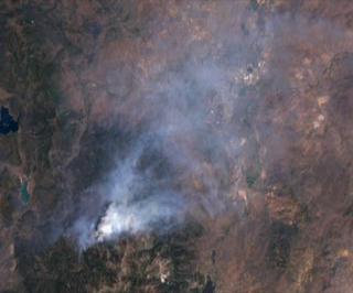
Reno Fire from Landsat: June 19, 2001
|
This animation is a simple zoom into the June 19, 2001 fire in Reno, Nevada. The original image is a Landsat 7 true color image of the fire between Lake Tahoe, Nevada and Reno, Nevada. Reno is under the smoke cloud.
|
|

|
|
Zoom to fire near Reno, from a Landsat image taken June 19, 2001
Duration: 5.0 seconds
Available formats:
320x240 (30 fps)
MPEG-1
722 KB
160x80
PNG
22 KB
80x40
PNG
6 KB
320x266
JPEG
11 KB
How to play our movies
|
|

|
|
Reno fire image from Landsat, taken June 19, 2001
Available formats:
2880 x 1944
TIFF
3 MB
320 x 216
JPEG
9 KB
|
| Animation Number: | 2191 |
| Animator: | Lori Perkins (SVS) (Lead) |
| Completed: | 2001-06-24 |
| Scientist: | Darrel Williams (NASA/GSFC) |
| Instrument: | Landsat-7/ETM+ |
| Data Collected: | 2001/06/19 |
| Series: | Landsat 7 |
| Video: | SVS2001-0005 * |
Keywords:
GCMD
>> EARTH SCIENCE
>> Biosphere
>> Ecological Dynamics
>> Fire Occurrence
GCMD
>> Location
>> Nevada
|
|
Please give credit for this item to
NASA/Goddard Space Flight Center
Scientific Visualization Studio, Landsat 7 Project, USGS EROS Data Center |
*Please note: the SVS does not fulfill requests for copies of the tapes in our library. On some of our animation pages, there is a direct link to a video distribution service from which tapes, handled by the Public Affairs Office (PAO)/Goddard TV, including some of our animations may be ordered. General information on this service can be found here. |
|
Back to Top
|
|
|
|

