- NASA Home
- > Missions
- > Hurricanes
- > Archives
- > 2009
Feature
Text Size
Landsat Sees Louisiana Wetland and Barrier Island Loss from Hurricane Gustav
01.12.09
 > Larger image
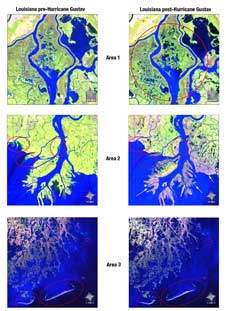
Landsat images before Gustav (Aug. 30 - left) and after (Oct. 1- right). False-color coded to see vegetation (green), bare or low vegetation (pink to white), and water (blues). Wetlands or flooded vegetation (purple) visible in Areas 1 & 2. Beach erosion on barrier islands in area 3. Credit: NASA Landsat, Mike Taylor Hurricane Gustav made landfall in coastal Louisiana on September 1, 2008, as a very strong category 2 (almost category 3) hurricane and left its mark on wetlands and barrier islands. NASA‘s Landsat 5 satellite, which is operated by the U.S. Department of the Interior’s United States Geological Survey (USGS), captured revealing images.
NASA satellites have many applications, including observations to improve understanding of the global integrated Earth system, improve forecasts of hurricanes, and help federal and state agencies assess damages produced by natural hazards such as hurricanes. Landsat 5 produces 185-kilometer (115 mile) images with a 30-meter (98 feet) ground sampling size that can discern areas changed by hurricanes and tropical storms. Landsat 5 can capture imagery of a given geographic location every 16 days.
The Landsat Program is a series of Earth-observing satellite missions jointly managed by NASA and the U.S. Geological Survey. Since 1972, Landsat satellites have collected information about Earth from space. This science, known as remote sensing, has matured with the Landsat Program.
After Hurricane Gustav made landfall on September 1, 2008, Landsat data provided picture-proof that wetlands and barrier islands off the Louisiana coast, southwest of New Orleans, were lost from hurricane-related flooding.
NASA’s Landsat Project Science Office, located at Goddard Space Flight Center, Greenbelt, Md., assembled before-and-after Landsat 5 images of the affected areas. Landsat 5 data showed that wetlands and barrier islands off the Louisiana coast, southwest of New Orleans, were destroyed from flooding as Hurricane Gustav made landfall.
 > Larger image
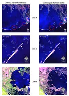
Beach erosion and impacts can be seen on barrier islands in areas 4 and 5. Significant amounts of vegetation loss and remaining flooded areas are clearly visible in Area 6. Credit: NASA Landsat, Mike Taylor The images on the left were acquired on August 30, 2008, while the images on the right were acquired October 1, 2008, a month after the hurricane made landfall near Houma, Louisiana. The images show the various impacts of the hurricane on the Louisiana coast. Some of the changes that can be seen in these images are land and wetlands loss (see Area 2), beach erosion and impacts on barrier islands (e.g. Areas 3, 4, and 5). Significant amounts of vegetation loss and remaining flooded areas are clearly visible in Areas 1, 2, 6, and 7.
In order to make certain aspects of the land stand out, scientists use false color. Information from the infrared and green portions of the electromagnetic spectrum were recorded by Landsat and put together to create these false color images. In these false color images, "vegetated areas look green, bare or low vegetation areas looks pink to white, and water bodies blue to dark blue," said Landsat Project Science Office scientist Dr. Eric Brown de Colstoun. "Wetlands or flooded vegetation are typically purple in color in theses images."
At 9:30 a.m. CDT (10:30 a.m. EDT) on September 1, Hurricane Gustav made landfall along the Louisiana coast near Cocodrie, La. as a strong Category 2 hurricane. It was 1 mph below Category 3 strength and dropped to a Category 1 storm four hours later. By the next day, it had been downgraded to a tropical depression. Thereafter, Gustav continued moving northwest through Louisiana and finally into Arkansas on September 3. According to the National Hurricane Center, as of September 15, 138 deaths had been attributed to Gustav in the U.S. and Caribbean. Gustav caused up to $15 billion in damages in the U.S. and $3 billion in damages when it raked over Cuba.
 > Larger image
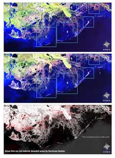
Landsat 5 image (top) of the Louisiana coast (Aug. 30, 2008). One month after Gustav (middle and bottom images). Boxed areas are enlarged to show the environmental impacts. Red (bottom image) areas were denuded by Gustav. Credit: NASA Landsat, Mike Taylor Hurricane Gustav was the seventh tropical cyclone, fourth costliest, third hurricane, and second major hurricane of the 2008 Atlantic hurricane season.
Landsat satellites have taken specialized digital photographs of Earth’s land cover and surrounding coastal regions since 1972, enabling the study of many aspects of the global integrated Earth system and evaluation of changes caused by both natural processes and human practices.
Goddard Space Flight Center