

Platte River Environmental Impacts and Restoration Study
Introduction
The Platte River flows generally eastward through Nebraska for 330 miles before joining the Missouri River near Plattsmouth, Nebraska. The focus of the central Platte River habitat recovery program includes ninety-five miles between Lexington and Chapman (Colorado, Nebraska, Wyoming, and the U.S. Department of the Interior, 1997; Figure 1).

Figure 1. Location map of the Platte River and central Platte Habitat Area in Nebraska
The Problem
The program seeks to restore some of the channel habitats of the threatened or endangered species: the Whooping Crane (Grus americana), the Piping Plover (Charadrius melodus) and the Interior Least Tern (Sterna antillarum athalassos) (DOI, 2004). A braided sand-bed river provides the desired habitat of a wide and shallow channel, multiple sand bars, and little or low-growing vegetation. Since the late 1800s, the plan form of the central Platte River has transformed from an almost continuously braided river to a mélange of meandering, anastomosed and braided reaches between Lexington and Chapman (DOI, 2006; Figures 2 and 3). In addition, the historically unvegetated river channel has narrowed substantially in the central Platte River in the twentieth century (Eschner et al., 1981, Peake et al., 1985, Currier et al. 1985, Sidle et al., 1989, and Williams, 1978).
The reduction in channel width has most often been attributed to the corresponding reduction in Platte River flows ensuing from reservoir construction and water storage in the North Platte and South Platte systems into the decade of the 1960s. Reclamation has further noted a sediment imbalance and topographic features as key influences on changes in river plan form and width (Figure 4), and has proposed restoration actions for the threatened and endangered species based on the processes that dominate the central Platte River morphology.
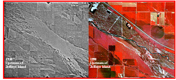
Figure 2. Comparison of plan form from 1938 (FWS, 1938) to 1998 (Friessen et al, 2000) at a location between Lexington and Overton. In 1938, the channel was a single, braided channel upstream of Jeffreys Island. In 1998, vegetation has expanded into the historic flood plain, and the river exhibits a meandering plan form.

Figure 3. Comparison of plan form from 1938 (FWS, 1938) to 1998 (Friessen et al, 2000) at a location upstream of Kearney. The 1938 braided channel, with small vegetated islands on the south bank, is in 1998 a multi-thread, anastomosed channel with large vegetated islands throughout.
Reclamation's Participation
Reclamation teamed with the U.S. Fish and Wildlife Service (FWS) to prepare the draft (DOI, 2004) and final (DOI, 2006) programmatic Platte River Environmental Impact Statements and continues to work with the Governance Committee of the Platte River Program to develop an Adaptive Management Plan for restoration of habitat for target species and for peak flow planning. The Sedimentation and River Hydraulics Group at Reclamation performed river-related geomorphic, sediment transport and flow analysis.

Figure 4. 1998 infrared photo (Friesen et al., 2000) illustrating river corridor, braided plan form, and anastomosed plan form. The photo displays one location where the river corridor width (topography) is controlling the river’s plan form.
SedVegGen3 Model
Development of a 1D sediment transport model, SedVeg-Gen3, by the Sedimentation and River Hydraulics Group has facilitated analysis of the central Platte River system. Expansion of vegetation into the historic flood plain has impacted both the quality of threatened and endangered species habitat, and the channel morphology (Figure 5). Subroutines developed by Simons and Associates were incorporated into the initial sediment transport model to track vegetation growth and mortality, provide adjusted bank resistance values, and improve sediment transport estimates (Figure 6). SedVeg-Gen3 analyses were used to advance understanding of the complex interactions of flow, sediment, topography and vegetation (bank resistance) on channel morphology, to track desirable habitat for multiple species, and to assess proposed management actions over a 61-year period.

Figure 5. September 2005 photo of Platte River upstream of Grand Island. This site had been disced the year of the photo to remove established vegetation, but shows the return of young plants in the flood plain during this relatively dry period.

Figure 6. Deposition/erosion comparison from SedVeg-Gen3 with and without vegetation.
Reclamation Reports
Four in-house reports and one contracted report present supporting data, summaries of analysis, assessments and conclusions.
- Simons & Associates, Inc. and URS Greiner Woodward Clyde. 2000. “Physical history of the Platte River in Nebraska: Focusing upon flow, sediment transport, geomorphology, and vegetation”. Prepared for Bureau of Reclamation and Fish and Wildlife Service Platte River EIS Office, dated August 2000. 100 p.
Simons & Associates et al. (2000) describe water resources development in the Platte River basin and the historic and current conditions of flow, sediment and vegetation in the central Platte River basin. In addition, processes associated with flow, sediment transport, and vegetation; causes of change in channel geometry; and mitigation measures are presented.
- Randle, T.J., and M.A. Samad. 2003. “Platte River flow and sediment transport between North Platte and Grand Island, Nebraska (1895-1999)”. Bureau of Reclamation, Technical Service Center, Sedimentation and River Hydraulics Group. Denver, Colorado. 60 p.
- Murphy, P.J., T.J. Randle, L.M. Fotherby, and J.A. Daraio. 2004. “Platte River channel: history and restoration”. Bureau of Reclamation, Technical Service Center, Sedimentation and River Hydraulics Group. Denver, Colorado. 167 p.
Murphy et al. (2004) address impacts of development on flow and sediment transport from the 1800s to the present including flow consumption and groundwater impacts. The authors also consider climate effects and provide background information on geology and Platte River morphology in geologic time. The processes of degradation and incision, grain size coarsening, vegetation impacts on sediment transport, and the concept of continuum of channel pattern are introduced with respect to the central Platte River.
- Holburn, E.R., L.M. Fotherby, T.J. Randle and D. Carlson. 2006. “Trends of aggradation and degradation along the central Platte River: 1985 – 2005”. Bureau of Reclamation, Technical Service Center, Sedimentation and River Hydraulics Group. Denver, Colorado. 180 p.
Holburn et al. (2006) present cross-section measurements of the central Platte River. Interpretated long-term trends of degradation, aggradation and stable river conditions are summarized and discussed.
- Murphy, P.J., L.M. Fotherby, T.J. Randle, and R.K. Simons. 2006. “Platte River Sediment Transport and Riparian Vegetation Model”. Bureau of Reclamation, Technical Service Center, Sedimentation and River Hydraulics Group. Denver, Colorado. 136 p.
In the Platte River Sediment Transport and Riparian Vegetation Model (Murphy et al., 2006), the one-dimensional sediment transport model of the central Platte Habitat (SedVeg Gen3) is presented, including: model history; program computations; sensitivity, calibration, and verification testing; reviews; revisions; input parameters; and data. The output for present conditions, projected 61 years, and an evaluation of the model are also included.
Randle and Samad (2003) provide historic information on Platte River mean annual flows, peak flows, and effective discharges, and estimates of historic sediment transport.
References
- Colorado, Nebraska, Wyoming, and the U. S. Department of the Interior (1997). Cooperative Agreement for Platte River Research and Other Efforts Relating to Endangered Species Habitats along the Central Platte River, Nebraska. Platte River Endangered Species Partnership, Cheyenne, Wyoming, 14 pp.
- Currier, P.J. (1997). Woody vegetation expansion and continuing declines in open channel habitat on the Platte River in Nebraska. In Proceedings of the Seventh North American Crane Workshop, January 10-13, 1996, Biloxi, MS, edited by R.P. Urbanek, and D.W. Stahlecker, 141-152. Grand Island, Nebraska: North American Crane Working Group.
- Eschner, T.R., R.F. Hadley, and K.C. Crowley (1983). Hydrologic and morphologic changes in channels of the Platte River basin in Colorado, Wyoming, and Nebraska: A historical perspective. U.S. Geological Survey Professional Paper 1277-A, 39 pp.
- Friesen, B., J. Von Loh, J. Schrott, J. Butler, D. Crawford, and M. Pucherelli (2000). Central Platte River, 1998 land cover/use mapping project, Nebraska. Technical Memorandum No. 8260-00-08. Bureau of Reclamation, U.S. Fish and Wildlife Service, DeU.S. Department of the Interior (USDOI) (2003). Platte River Recovery Implementation Program Draft Environmental Impact Statement. Bureau of Reclamation and U.S. Fish and Wildlife Service, Platte River EIS Office, Denver, Colorado.
- Sidle, J.G., E.D. Miller, and P.J. Currier (1989). Changing habitats in the Platte River Valley of Nebraska. Prairie Naturalist, 21: 91-104.
- Williams, G. (1978). The case of the shrinking channels- the North Platte and Platte Rivers in Nebraska. U.S. Geological Survey Circular 781, 48 pp.
- U.S. Department of the Interior (USDOI) (2006). Platte River Recovery Implementation Program Final Environmental Impact Statement. Bureau of Reclamation and U.S. Fish and Wildlife Service, Platte River EIS Office, Denver, Colorado.
- U.S. Fish and Wildlife Service (FWS) (1938). Platte River 1938 Black & White Aerial Photography. Prepared for the Agricultural Stabilization and Conservation Service (ASCS).U.S. Fish and Wildlife Field Office in Grand Island, Nebraska (GIFO).