Pacific Northwest Forest Inventory and Analysis
| PNW-FIA Home | |
| About Us | |
| Contact Us | |
| Links | |
| Maps | |
| Newsroom | |
| Publications, Data & Other Products | |
| Statewide Results | |
| US Forest Service | |
| Pacific Northwest Research Station |
|
| Region 6 | |
| Evaluate Our Service Your comments and suggestions are very important to our service improvement. |
Pacific Northwest Forest Inventory and Analysis Portland, OR 97208-3890 (503) 808-2000 |
|
|
|
What is FIA?
Forest Inventory and Analysis (FIA) is the Nation's forest census. The Pacific Northwest Research Station (PNW) is one of five Research Stations with an FIA program. It is our job to determine the extent and condition of forest resources and analyze how these resources change over time. The inventories are conducted across all ownerships in Alaska, California, Hawaii, Oregon, Washington, and the US Pacific Territories regardless of management policies. PNW-FIA has been in operation under various program names (Forest Survey; Inventory and Economics; Inventory, monitoring and Evaluation; and Pacific Resources Inventory, and Evaluation) for some 70 years. The program is implemented in cooperation with a variety of partners including state forestry agencies and private landowners who grant access to their lands for data collection purposes.
The Three Phases of FIA
FIA consists of a nationally consistent core program, which can be enhanced at the regional, state, or local level by collecting additional data to address special interests. The national core consists of three phases:
Phase 1 uses remote sensing imagery or aerial photography
to classify land into forest or non-forest and to identify landscape patterns
such as fragmentation
and urbanization. Historically, this phase was accomplished exclusively with
aerial photographs. Methods are shifting to a system based on satellite
imagery.
Phase 2 consists of permanently established field plots
distributed across the landscape with approximately one plot every 6,000
acres. In the West, field
crews visit 10 percent of forested sample locations each year to collect a
variety of forest ecosystem data. Non-forest locations are also visited as
necessary to quantify rates of land use change. A typical plot usually takes
a 2-3 person field crew one full day to complete. Factors such as the steepness
of the ground, the size of trees, amount of understory vegetation, and the
length of the hike to the plot all factor into the time commitment. When a
field crew visits a plot, some of the information collected includes:
- Tree diameter, length, damage, amount of rotten or missing wood, and tree quality
- Counts of tree regeneration
- General land use
- Stand characteristics such as forest type, stand age, and disturbance
- Changes in land use and general stand characteristics
- Estimates of growth, mortality, and removals (determined by revisiting plots every ten years)
- Vegetation diversity and structure
- Down woody debris

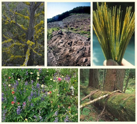
Phase 3 is designed to assess forest health by sampling a subset of Phase 2 plots. Plots are visited only during the growing. Phase 3 measurements relate to forest ecosystem function, condition, and health. They include:
- Ozone Injury -the presence and severity of ozone injury on certain forest plants shows us where ozone exposures are high enough to cause plant injury and increase susceptibility to other stressing agents. For more information, visit the national FIA ozone website.
- Lichen Communities-the presence or absence of certain lichen species is an indication of air quality climate and forest structure, age, density, and composition. For more information, visit the national FIA lichen website.
- Soil attributes-measurements of soil erosion, compaction, and physical or chemical properties allow us to evaluate soil fertility, carbon storage, and physical status of the site.
- Crown Condition-measurements of crown density, transparency, and dieback help us differentiate between trees with high vigor and those under stress.
- Vegetation Diversity and Structure-measurements of native and exotic plants help us evaluate changes in plant community diversity, spread of invasive species, fuel loading, carbon cycling, and effects of disturbance.
- Down Woody Material-measurements of fine and coarse woody material on the forest floor allow us to assess fuel loading, forest productivity, wildlife habitat, and carbon storage. For more information, visit the national FIA down woody material website.
Organizational Overview
FIA is organizationally located within the Research and Development Deputy Area of the USDA Forest Service. FIA has three levels of internal management: an executive level involving senior executives from the Forest Service and State Forestry Agencies, who provide broad policy guidance; a management level consisting of field program managers from the Forest Service and States responsible for implementing the program on a day-to-day basis; and a technical level consisting of groups of technical specialists drawn from the Forest Service and States, who develop, document, and review program procedures. Across the country, program work is coordinated out of five regional field offices. Each region maintains their own internal set of regional customers and partners who collaborate in program implementation.
Every 5 years the National Forest System and Forest Service Research combine
their data for the Resources Planning Act (RPA) Assessment of the Nation's
resources. The RPA data is retrievable at the regional, state and county levels
The People of PNW-FIA
PNW-FIA is based in Portland, OR with a satellite office in Anchorage, AK. Scientists, foresters, ecologists computer professionals, and technicians from many backgrounds provide the expertise needed to implement the PNW-FIA program.
Program Manager
Sue Willits
FIA Teams and team leaders in Portland (Oregon, Washington, California, Hawaii,
and US Pacific Islands)
Environmental Analysis and Research: Jeremy Fried
Inventory Reporting and Mapping*: Sally Campbell
Data Collection: Bob Rhoads
Information Management*: George Breazeale
FIA Teams and team leaders in Anchorage (Alaska)
Research and Analysis: Bill van Hees
Data Collection: Ray Koleser
*The Inventory Reporting and Mapping Team and the Information Management Team
serve Anchorage as well as Portland.
Data Flow and Uses
Phase 1 determines which plots are forested and which are non-forest. Field crews visit the forested plots (Phases 2, 3) on the ground. After the collected field data are edited for correctness and consistency (by the two data collection teams), they are compiled using both national and regional computer programs that generate computed values of a number of desired measurements such as biomass and volume (by the information management team). The compiled data are then added to the national FIA database (by the information management team). The data can then be summarized, analyzed and published (by the inventory reporting team and the 2 research teams).
Our data is available to any interested individual or organization. Although we typically summarize the data at the state or multi-county level, other political and biological entities such as national forests and ecoregions, whose boundaries are rarely congruent with county or state boundaries, can also be accommodated. For more information about accessing the data see our data page.
FIA data answers such questions as:
- How much forest is there?
- What do the forests looks like?
- Is forest area increasing or decreasing?
- Are we gaining or losing species?
- How quickly do trees grow? die? get harvested?
- How is the forest ecosystem changing over time?
- How are soils changing?
- What about other vegetative attributes?
Such information has many important uses including:
- Helps policy makers at the federal and state level to formulate good forest policy, and assess the sustainability of current and past policy.
- Enables land managers to devise better management plans and to assess the effects of current and past management practices on the land.
- Serves as a starting point for scientific investigations in a variety of areas which involve changes in forest ecosystems over time.
- Formulates business plans which will be both economically and ecologically sustainable over time.
- Keeps the public informed about the health and sustainability of the Nation's forests.
US Forest Service - Pacific Northwest Forest Inventory and Analysis
Last Modified: Friday, 14 March 2008 at 13:01:26 EDT