 Louisiana's Wetlands: A Lesson in Nature Appreciation
 Hurricane Katrina’s disastrous flooding of
the Gulf Coast confirmed three decades of warnings
by scientists. Most of New Orleans is below sea level,
and South Louisiana’s coastal wetlands, which
once helped buffer the city from giant storms, have
been disappearing at a spectacularly swift pace. Now
some researchers are calling for restoration of wetlands
and barrier islands to help protect New Orleans the
next time a hurricane strikes.
An average of 34 square miles of South Louisiana
land, mostly marsh, has disappeared each year for the
past five decades, according to the U.S. Geological
Survey (USGS). As much as 80% of the nation’s
coastal wetland loss in this time occurred in Louisiana.
From 1932 to 2000, the state lost 1,900 square miles
of land to the Gulf of Mexico.
By 2050, if nothing is done to stop this process,
the state could lose another 700 square miles, and
one-third of 1930s coastal Louisiana will have vanished.
Importantly, New Orleans and surrounding areas will
become ever more vulnerable to future storms. “New
Orleans can’t be restored unless we also address
coastal and wetland restoration too,” says Craig
E. Colten, a geographer at Louisiana State University
(LSU).
A River and a City
The vast watershed of the Mississippi River ranges
from Montana in the west to New York state in the east.
Spring rains send sediment-rich runoff into the river
and its tributaries. For thousands of years, the Big
Muddy has flowed down to the Gulf of Mexico, where
great floods periodically burst over the riverbanks,
allowing huge quantities of silt to settle and nourish
wetlands. The land naturally sinks, or subsides, as
loose sediments from the Mississippi River settle and
compact.
The river slows as it reaches the gulf because of
the tides pushing upstream; as it slows down, it spreads
out and delivers much of its sediment load into deltaic
deposits. The Mississippi Delta was fed by these influxes
of mud, creating 5 million acres of South Louisiana
before the twentieth century. Every millennium or so,
the Mississippi River would change direction at its
gulf outlet, meandering from east to west and back
again. As a result, the river created six different
delta “lobes” on which the entire coastline
of South Louisiana was formed.
In 1718, French settlers founded New Orleans on a
natural ridge of high land on a bend of the Mississippi
River, with Lake Pontchartrain (which is actually an
inlet of the Gulf of Mexico) to the north and coastal
wetlands to the east, west, and south. But flooding
was a problem. By 1812, the settlers had built levees
on the east bank to Baton Rouge, 130 miles upstream,
and on the west bank as far as Pointe Coupée,
165 miles upstream.
Over the next two centuries, the city drained surrounding
wetlands to prevent disease and encourage development.
The city eliminated swamps following mosquito-borne
yellow fever epidemics that killed 40,000 residents
between 1817 and 1905. As the city grew, the only lands
available for development were low-lying areas north
toward Lake Pontchartrain. At the turn of the twentieth
century, the city created an integrated public works
department, which was responsible for draining the
wetlands.
“It was the draining of the lower areas that
allowed suburbanization to occur,” says Colten.
But the lowlands, originally just inches above sea
level, steadily sank. “When you drain these areas,
you suck the water out of the peaty soils, which begin
to compress, or subside,” he says. “That’s
why these areas have continued to subside.”
New Orleans also continually built higher and stronger
levees to contain river flooding. In 1928, Congress
authorized major levee improvements, and the U.S. Army
Corps of Engineers began shoring up the flood control
system, including levees, along the entire lower Mississippi
and in New Orleans. By the 1950s, LSU geology professor
James P. Morgan had begun to document dramatic rates
of land loss in Louisiana’s coastal zone, which
stretches 300 miles from the Texas border to the Mississippi
state line and 50 miles inland.
The River Today
Today, South Louisiana is one of most intensively
engineered places in the nation. Vast quantities of
water are diverted or rerouted through a lacework of
navigation corridors held in place by 2,000 miles of
earthen, rock, and concrete levees. Walled off from
the floodplains, the river can no longer provide enough
silt to the delta to keep up with natural subsidence
and sea level rise. About two-dozen dams also hold
sediment back from the river and its tributaries. “We
have tamed the river for the almost exclusive benefit
of navigation,” says David R. Conrad, a senior
water resources specialist with the National Wildlife
Federation.
The construction of high levees did end the spring
floods along the lower Mississippi, but at an environmental
cost, eventually eliminating many of the wetlands,
floodplains, and barrier islands of the delta. “When
you lose wetlands and floodplains, you lose their natural
services including storage capacity during floods,
and when you lose coastal wetlands, you lose wave and
storm protections,” says Sandra Postel, director
of the Global Water Policy Project, a nonprofit organization
based in Amherst, Massachusetts. “Katrina in
South Louisiana was an example of what happens when
you disturb the natural infrastructure.”
In November 2005, the National Academies released
a report, Drawing Louisiana’s New Map: Addressing
Land Loss in Coastal Louisiana. The report notes
that building and maintaining levees and dams along
the Mississippi River was a “more or less ubiquitous” cause
of wetland loss. Another geographically widespread
cause was voracious grazing by nutria, a nonnative
species, which destroyed wetland vegetation.
But the report also points out that there were other
causes “superimposed on these broad influences,” particularly
including activities by the oil and gas industry. Peaking
during the 1960s through the 1980s, oil and gas companies
dredged canals for exploration. There are currently
10 major navigation canals and 9,300 miles of pipelines
in coastal Louisiana serving about 50,000 oil and gas
production facilities. These canals, which are perpendicular
to the coast, have created new open water areas, drowning
wetlands and allowing saltwater intrusion into freshwater
ecosystems. The result--land loss hot spots. “There
is also evidence,” the report says, “that
extraction of large volumes of oil and gas has exacerbated
the problems of inundation and saltwater intrusion”--that
is, withdrawing oil and gas along geologic faults seems
to exacerbate subsidence in coastal Louisiana.
The Mississippi Delta is also home to South Louisiana’s
port complex, which lines both banks of the Mississippi
River for 172 miles as well as points offshore, including
the Port of New Orleans, the Port of South Louisiana,
the Port of Baton Rouge, and the Louisiana Offshore
Oil Port in the Gulf. Because of its size and location,
adjacent to oil and gas refineries and drilling platforms,
this port complex is one the most important in the
United States. Louisiana’s coastline produces
one-fifth of the country’s oil and one-quarter
of its natural gas. Through South Louisiana’s
ports the bulk commodities of U.S. agriculture--corn,
wheat, and soybeans--are sent around the world, and
the bulk commodities needed for American industry--steel
and concrete, for instance--come into the country.
The Mississippi River Gulf Outlet, a little-used
40-year-old shipping channel connecting the Gulf of
Mexico to the Mississippi River, is believed to have
served as a funnel for Katrina’s storm surge.
The navigation channel and the eastern levee of the
Mississippi River seem to have directed high water
into the Breton Sound estuary southeast of New Orleans,
according to Greg Steyer, a USGS wetland scientist.
From there, the surge poured into Lake Pontchartrain
and an industrial canal, where it overwhelmed levees,
contributing to flooding in St. Bernard Parish and
the Lower Ninth Ward of New Orleans. Like the oil and
gas canals, the outlet also allows saltwater intrusion
and tidal action into freshwater ecosystems, killing
vegetation and turning the marsh into a stretch of
open muddy water.
The Gulf of Mexico is also subject to the general
sea level rise being observed worldwide, with potential
ramifications for the Gulf Coast. Over the past century,
the warming climate has pushed up mean sea level four
to eight inches worldwide, and computer models suggest
that this rise will probably accelerate, according
to a 2001 report of the U.S. Global Change Research
Program, Climate Change Impacts on the United States:
The Potential Consequences of Climate Variability and
Change. By 2100, global sea level is projected
to rise an additional 19 inches along most of the U.S.
coastline.
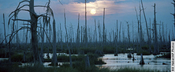
Death of the Wetlands
This combination of factors has killed wetlands in
South Louisiana from the inside out. “Some of
the inner marshes have actually eroded faster than
some of the extreme coastal areas,” says Gary
Fine, manager of the Natural Resources Conservation
Service’s Golden Meadow Plant Materials Center
in Galliano, Louisiana. In the delta, sediment deposits
from tidal creeks and rivers build up the banks, creating
modest natural ridges. Land elevations fall toward
the center of coastal marshes, freshwater swamps, and
bald cypress forests. Starved of new sediments and
flooded by tides, the inner areas become constantly
submerged. “Especially in the salt marshes,” Fine
explains, “the plants start dying in the center
due to rising water and decreasing sediments, and then
the loss expands outward to the edges.” As a
result, South Louisiana has become a patchwork of open
water and remnant wetlands.
“By 2050, the city will be closer to and more
exposed to the Gulf of Mexico,” noted authors
of a restoration proposal, Coast 2050: Toward a
Sustainable Coastal Louisiana. Hurricane Katrina
itself pushed the city closer to the coast. The hurricane,
making landfall in lower Plaquemines Parish, had a
storm surge of almost 30 feet, which caused extensive
erosion at the coastal edge. For example, Katrina almost
wiped out the Chandeleur Islands, a 40-mile-long series
of uninhabited barrier islands southeast of New Orleans. “The
sand and marsh are gone,” says Asbury Sallenger,
an oceanographer with the USGS Center for Coastal and
Watershed Studies in St. Petersburg, Florida. “Before
Katrina, the islands were five meters high; now there’s
a less than half a meter left.”
Gregory W. Stone, a coastal geologist at LSU, says
that if the current trend of wetland loss and barrier
island erosion continues, it will worsen the effects
of future hurricane surges in South Louisiana. “Storm
surge and storm waves will increase if we lose more
wetlands and our barrier coast,” he says. “Wetlands
and barrier islands are the first line of defense.
That means areas such as New Orleans would become more
vulnerable to inundation.”
Further land loss would also endanger oil and gas
facilities, the huge port complex, and the gulf’s
valuable fishing industry. South Louisiana’s
wetlands are critical nursery areas for commercially
important marine species, including shrimp, blue crabs,
oysters, redfish, and menhaden. Land loss in South
Louisiana, says Stone, “is not a local problem--it’s
a national problem.”
Restoration Plans
In an effort to rebuild the state’s natural
infrastructure, Congress passed the 1990 Coastal Wetlands
Planning, Protection, and Restoration Act, sponsored
by Senator John Breaux (D-LA). The Breaux Act provides
about $50 million each year for wetlands restoration
projects in Louisiana. The Breaux Act has provided
funding for 118 restoration projects, and 75 projects
have already been built. But most of these projects
are relatively small in scale.
In 1996, the state of Louisiana and a group of federal
agencies joined with parish officials and the public
to create a consensus document. The result, after 65
public meetings over 18 months, was Coast 2050,
which outlined strategies and measures needed to restore
the state’s wetlands and barrier islands.
Coast 2050 proposed that the Mississippi River
be re-engineered to imitate natural processes. That
is, some portion of the river’s flow should be
re-diverted via pipelines or canals to flush into the
delta so that South Louisiana’s sinking ecosystems
could be built up. “Coast 2050 essentially
calls for putting holes in the straitjacketed Mississippi
River,” says Conrad. “This process could
be one of the most interesting and expensive and important
environmental engineering processes ever. It is a huge
opportunity to put things back together if we have
the will.”
These water diversions would feed freshwater marshes
and control saltwater intrusion from being pushed upriver
by the rising sea level. The Caernarvon Freshwater
Diversion Project, funded in the mid-1980s, could be
one model for this approach. The diversion consists
of a $26-million opening in the river levee built by
the Army Corps about 24 miles south of New Orleans.
A concrete culvert diverts water into a canal that
feeds marshes behind Breton Sound, which had been losing
land. This diversion has been shown to increase marsh
and freshwater plant acreage.
Coast 2050 also recommended that federal
agencies dredge soils and ancient sandbars to create
new marshlands; plug up the Mississippi River Gulf
Outlet; and shore up barrier islands that are the first
line of defense against approaching hurricanes. However,
the cost cited in the report for all these projects
seemed too huge to consider: $14 billion (by comparison,
estimates for rebuilding after the 2005 hurricane season
have been placed as high as $200 billion).
Kerry St. Pé, director of the Barataria-Terrebonne
National Estuary Program, says there’s no time
to waste. Freshwater diversions alone are not enough
to solve the land loss problem, he adds. Dredge material
should be pumped immediately via pipes from navigation
channels in the delta, including the Mississippi River,
to shore up hot spots of wetland loss. “We need
the sediment now,” he says. The Corps of Engineers
already dredges 40-45 million cubic yards of sediment
from the delta’s numerous navigation channels
each year, he says, and the material is discharged
off the end of the continental shelf because that’s
the least expensive method of disposal. “We could
use that sediment to build wetlands,” says St.
Pé.
From 2000 through 2003, the Corps of Engineers and
the state of Louisiana collaborated on a feasibility
study for a $17-billion coastal restoration plan lasting
30 years. Yet this study, based on Coast 2050,
also seemed far too expensive at the time. “It
never went up to Congress because it exceeded what
potentially could be funded,” says Steyer. “We
were asked to focus it on more of the near term, over
ten years, addressing what are the critical projects
that could be done.”
In November 2004, state and federal agencies proposed
a near-term effort, the Louisiana Coastal Area Ecosystem
Restoration Study. The findings from this study led
to the 2005 Water Resources Development Act, which
calls for Congress to spend $1.9 billion over 10 years
on restoration efforts in the delta; the bill is still
being worked out in Congress. The act--intended to
be a first, smaller step toward a 30-year $17-billion
plan--follows the strategies of Coast 2050,
says Steyer.
However, Oliver Houck, who directs the environment
program at Tulane University Law School, says that
nothing less than letting the river go its own way
will solve the land loss problem. “Coast 2050 is
history,” he says. “Katrina upped the ante
so much. What has to be done now is to let the Mississippi
River take its natural course and allow the full bed
load of the river to rebuild the marsh.” He adds, “The
problem with Coast 2050 and other restoration
plans is that they fail to halt wetland destruction
in the same areas they are trying to restore. New canals,
deeper canals, expanded ports are all on the table.
No way that works.”
Indeed, if water control projects were destroyed
and the Mississippi were allowed to take its natural
course, it would inevitably become captured by the
Atchafalaya River, which empties off the southcentral
coast of Louisiana. The combined flow and increased
sediment load would help build up the most land-starved
region of Louisiana’s coast. But if the Mississippi
River were set free, one of today’s most important
shipping channels would become water-starved from Baton
Rouge to the gulf outlet.
So how would giant oceangoing ships reach the ports
of South Louisiana? Houck recommends cutting an entirely
new shipping channel from the gulf to the port complex
of South Louisiana. Where would this channel be located? “That’s
up to the engineers,” Houck says.
A Muddy Future
No matter how it’s done, there is a new urgency
to address the land loss problem. Senator Mary Landrieu
(D-LA) has proposed a Hurricane Katrina Disaster Relief
and Economic Recovery Act, cosponsored by Senator David
Vitter (R-LA). This proposal would provide $250 billion
for hurricane reconstruction, including $40 billion
in ecosystem restoration and levee improvements. Some
feel, though, that this proposal actually hurt Louisiana’s
chances for restoration monies by appearing to reach
for too much to fund a grab bag of projects. “Major
restoration funding remains in doubt,” says Houck, “as
indeed does the mega-question: how to restore.” At
press time the bill had not made any progress.
It has taken a major hurricane to show the nation
that it’s necessary to rebuild the wetlands and
barrier islands of Louisiana. Although stakeholders
have generally agreed on a plan to rehabilitate these
resources, major funding has not been available. To
restore New Orleans to health after Hurricane Katrina,
though, it seems clear that the nation must find a
way to fund the largest ecological rehabilitation project
in U.S. history, a comprehensive effort to rebuild
South Louisiana’s disappearing landscape.
John Tibbetts
|