|
|
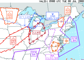
| Synopsis: |
|---|
AIRMETs (Airmen’s Meteorological Information) are regularly scheduled package of 00, 03, and 06 hour forecasts with a 09 and 12 hour outlook period issued every 6 hours, where there is a 50% probability that any of the following conditions will cover an area of 3000 square miles or greater:
- Instrument flight Rule conditions (IFR): Ceilings are expected to be below 1000ft and/or visibilities are expected to be below 3SM.
- Mountain Obscuration: An area of terrain is obscured by clouds, precipitation or fog.
- Icing: When moderate or greater icing conditions are expected to occur. Icing AIRMETs include freezing level information.
- Turbulence: when moderate or greater turbulence conditions are expected to occur for less than half of the forecast period.
- Low Level Wind Shear (LLWS): when LLWS is expected to occur.
- Strong Surface Winds: when sustained surface winds are greater than or equal to 30kts.
|
| The Graphical AIRMET products Contain: |
|---|
AIRMET Snapshots (sometimes including optional “special snapshots”) and FBBAs (From/Bounded By/Along lines) of the following Aviation Weather Hazards:
- IFR
- Mtn Obscuration
- ICE
- Multiple Freezing Level
- Freezing Levels (Lowest)
- Low Turbulence
- High Turbulence
- Surface Winds
- Low Level Wind Shear
|
| Navigation: |
|---|
| 1) Select parameter by selecting appropriate button. Note that the button color will change to the color of the associated graphic |
 |
To deselect ... click on button again ... or select the  button button |
| 2) Select Valid time by clicking on a "valid time" or moving the button on the slider bar. |
 |
| or |
Click  to start looping and to start looping and  to stop looping. to stop looping. |
| The will reset the page. |
|
| |
| Legends: |
|---|
|
|
| |
| Details: |
|---|
| A snapshot is simply the depiction of an aviation weather hazard at a given point in time, much like a photograph. Snapshots are required of all elements at 0-, 3-, 6-, 9-, and 12-hours (sometimes including "special snapshots"). |
| A FBBA (From/Bounded By/Along line) (pronounced “fibba”), which replaces the old idea of a smear, is the union of snapshots over a period of time. For AIRMETs, the FBBA is the union of uniquely tagged snapshots in the first six hours of the forecast. This is the FROM line that is available in the text AIRMETs and on ADDS. For OUTLOOKs, the FBBA is the union of uniquely tagged snapshots in the last six hours of the forecast. The Outlook is available in the text AIRMETs only. The formatter will generate separate OTLK text if the OTLK FBBA extends more than 3000 nmi2 into another state or covers an additional 25% of the same state as the AIRMET. |
| Special snapshots are snapshots valid at some point in time during the 6-hour AIRMET period other than the 0-hr, 3-hr or 6-hr standard forecast periods for a particular hazard and tag number. They are transmitted at the normal issuance times of the 3-hourly snapshots, but can also be introduced in corrections and amendments. Specials snapshots are not issued for the 6-12 hour OUTLOOK period. Special snapshots can be issued with 15-minute resolution from forecast hour 0 (F0) through forecast hour 6 (F6). |
| |
| File Availability: |
|---|
| AIRMETs are issued every 6 hours ... at 0255Z, 0855Z, 1455Z, and 2055Z. |
| |
| WMO Headers (BUFR): |
| AIRMET | Aviation Hazard | WMO HEADER |
|---|
| SIERRA | IFR Ceiling | JUGE86 KKCI |
| IFR Visibility |
| Mountain Obscuration |
| TANGO | Turbulence | JUHE00 KKCI |
| Strong Surface Wind |
| Low Level Wind Shear Potential |
| ZULU | Icing | JUIE00 KKCI |
| Lowest Freezing Levels |
| Multiple Freezing Levels |
|
| |
|
|
| |
| Additional Resources: |
|---|
 | G-Airmet Presentation (July 2008): PPT PDF |
|
| |
| FAQs: |
|---|
| What is a snapshot? |
| A snapshot is simply the depiction of an aviation weather hazard at a given point in time, much like a photograph. The model data we view are depictions of weather variables at an instant in time. For example, a snapshot of AIRMET ICE valid at 0300 UTC depicts a volume of airspace where a forecaster believes there is a > 50% probability of moderate icing conditions. |
| |
| What is a FBBA? |
A FBBA (pronounced “fibba”), which replaces the old idea of a smear, is the union of snapshots over a period of time. For AIRMETs, the FBBA is the union of uniquely tagged snapshots in the first six hours of the forecast. For OUTLOOKs, the FBBA is the union of uniquely tagged snapshots in the last six hours of the forecast.
Note: The sixth-hour (F6) snapshot is included in both the AIRMET and the OUTLOOK. The formatter will generate separate OTLK text if the OTLK FBBA extends more than 3000 nmi² into another state or covers an additional 25% of the same state as the AIRMET.
The FROM lines for the text AIRMET are created from the FBBAs.
|
| |
| When are special snapshots used? |
They are used to:
- To begin a particular hazard at a time other than forecast hour 0, 3, or 6,
- To depict a non-linear trend (with respect to areal coverage and/or movement) of a hazard during the 6-hour forecast period,
- To end a particular hazard at a time other than forecast hour 3 or 6, and,
- When issuing an update at a time which is outside the 15-minute time resolution window of the 3-hr, or 6-hr snapshots.
|
|
|
|