Follow this link to skip to the main content
NASA logo and link JPL logo
JPL Home EARTH Stars and Galaxies Science and Technology
Caltech Logo
Email News RSS Podcast Video
Mission to Mars' north poloar region Phoenix Mars Lander
› View Archives | › View 3D Images | › Raw images
 
Contour Map of Mars' Surface Beside Phoenix
2008-12-15
  Contour Map of Mars' Surface Beside Phoenix

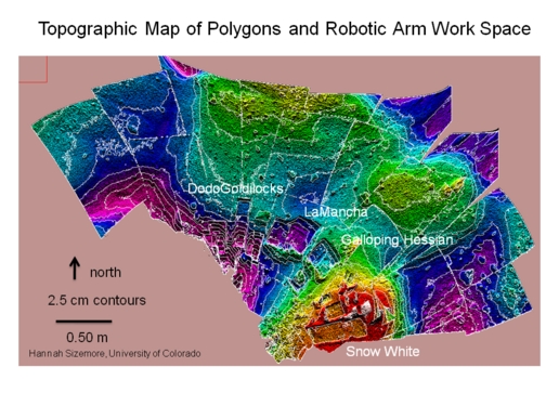
This color-coded elevation map of the local terrain on the north side of NASA's Phoenix Mars Lander shows the contours of polygons and relationship of polygon boundaries to trenches and other features in the workspace of the lander's Robotic Arm.

The map covers an area about 4 meters (13 feet) across. Areas coded red, yellow and green are higher than areas coded blue and purple.

The Phoenix Mission is led by the University of Arizona, Tucson, on behalf of NASA. Project management of the mission is by NASA's Jet Propulsion Laboratory, Pasadena, Calif. Spacecraft development is by Lockheed Martin Space Systems, Denver.

Image NASA/JPL/University of Arizona/University of Colorado
   
  › Larger image
› Higher Resolution
› View Archives


Related Links
› NASA Phoenix site

› University of Arizona Phoenix site

› JPL on Facebook and Twitter

› Landing Press Kit (3Mb - PDF)

› Launch Press Kit (6.5Mb - PDF)

› Mission Fact Sheet (244Kb - PDF)

› NASA Mars Exploration site

› NASA/JPL Landing Blog

Other Missions at Mars
› Mars Exploration Rovers

› JPL's Rover News and Image

› Mars Reconnaissance Orbiter

› Mars Odyssey

› Mars Express

 
   usa gov PRIVACY     |    FAQ     |     FEEDBACK Site Manager: Susan Watanabe
Webmasters: Tony Greicius, Martin Perez