
Ask Us!
Frequently Asked Questions
 Please select from the following topics or simply scroll down the screen:
If you have a question that is not addressed in these "Frequently Asked Questions,"
contact our Service Section.
You may contact any other section, office, or staff member by calling (304) 594-2331
or faxing to (304) 594-2575.
Please select from the following topics or simply scroll down the screen:
If you have a question that is not addressed in these "Frequently Asked Questions,"
contact our Service Section.
You may contact any other section, office, or staff member by calling (304) 594-2331
or faxing to (304) 594-2575.
- Highest Point: Spruce Knob, at 4,861 feet, in the Circleville District of Pendleton County:
		latitude/longitude coordinates:	38º 41' 59.09" north latitude,
						79º 31' 58.91" west longitude
		UTM coordinates:  627569E, 4284272N
(Source: U.S.G.S. "Spruce Knob" 7.5-minute quadrangle; WVGES Gazetteer, v. V-24)
- Lowest Point: Harpers Ferry, at 280 feet, in the Harpers Ferry District of Jefferson County
(the benchmark near the intersection of the Potomac and Shenandoah rivers at Harpers Ferry indicates 287 feet, but
it is situated above the river):
		latitude/longitude coordinates:	39º 19' 33.58" north latitude,
						77º 44' 2.59" west longitude
		UTM coordinates:  264320E, 4356310N
- Number of 7.5-minute (1:24,000-scale) topographic quadrangles that cover the State: 496
- Number of 1:100,000-scale topographic quadrangles that cover the State: 27
- Number of named coal seams in the State: 117
- Approximate number of minable coal seams in the State: 62
- Number of counties with coal production reported in 2002: 26
Map of Coal Production reported in 2002
- West Virginia's most active counties for coal production reported in 2007:
Top West Virginia Counties by
Coal Production Volume |
| Rank |
County |
Volume |
| 1 |
Boone |
33,398,376 tons |
| 2 |
Logan |
14,578,586 tons |
| 3 |
Kanawha |
12,157,122 tons |
| 4 |
Marion |
12,135,722 tons |
| 5 |
Mingo |
12,085,029 tons |
| 6 |
Monongalia |
10,383,162 tons |
| 7 |
Marshall |
9,745,298 tons |
| 8 |
Raleigh |
9,131,570 tons |
| 9 |
McDowell |
5,953,445 tons |
| 10 |
Webster |
5,110,202 tons |
- Number of named oil and gas fields in the State: 390 (as of January 2008)
- Deepest wells drilled in the State:
- Calhoun 2503 at 20,222', drilled in 1974 by Exxon USA
- Mingo 805 at 19,600', drilled in 1973 by Columbia Gas Transmission
- Lincoln 1469 at 19,124', drilled in 1974 by Exxon USA
- Number of counties with oil and gas wells: Wells have been drilled in 53 of the State's 55
counties; the only two counties with no oil or gas wells are Berkeley and Jefferson counties in the eastern panhandle.
- Number of counties with gas production reported in 2001: 47,
Map of Gas Production reported in 2001
- West Virginia's most active counties for gas production reported in 2006*:
Top West Virginia Counties by
Gas Production Volume |
|
Top West Virginia Counties by
Gas Well Count |
| Rank |
County |
Volume |
|
Rank |
County |
Well Count |
| 1 |
Wyoming |
27,025 MMcf |
|
1 |
Ritchie |
3,740 wells |
| 2 |
McDowell |
19,152 MMcf |
|
2 |
Gilmer |
2,854 wells |
| 3 |
Lewis |
14,373 MMcf |
|
2 |
Lewis |
2,854 wells |
| 4 |
Harrison |
13,182 MMcf |
|
4 |
Harrison |
2,720 wells |
| 5 |
Kanawha |
12,532 MMcf |
|
5 |
Doddridge |
2,457 wells |
| 6 |
Logan |
12,113 MMcf |
|
6 |
Kanawha |
2,274 wells |
| 7 |
Doddridge |
9,839 MMcf |
|
7 |
Upshur |
1,938 wells |
| 8 |
Mingo |
9,768 MMcf |
|
8 |
Calhoun |
1,804 wells |
| 9 |
Lincoln |
8,638 MMcf |
|
9 |
Lincoln |
1,773 wells |
| 10 |
Boone |
6,839 MMcf |
|
10 |
Wyoming |
1,737 wells |
* Summary volumes and counts computed from data reported to WVDEP Office of Oil and Gas and available in the WVGES oil and
gas well database as of December 2002; MMcf = million cubic feet of gas.)
Top West Virginia Counties by
Oil Production Volume |
|
Top West Virginia Counties by
Oil Well Count |
| Rank |
County |
Volume |
|
Rank |
County |
Well Count |
| 1 |
Wetzel |
306,546 bbl |
|
1 |
Ritchie |
1,036 wells |
| 2 |
Tyler |
259,339 bbl |
|
2 |
Roane |
905 wells |
| 3 |
Harrison |
142,513 bbl |
|
3 |
Gilmer |
833 wells |
| 4 |
Ritchie |
126,179 bbl |
|
4 |
Doddridge |
621 wells |
| 5 |
Roane |
107,757 bbl |
|
5 |
Harrison |
551 wells |
| 6 |
Doddridge |
97,913 bbl |
|
6 |
Calhoun |
539 wells |
| 7 |
Calhoun |
83,977 bbl |
|
7 |
Kanawha |
458 wells |
| 8 |
Gilmer |
83,802 bbl |
|
8 |
Lewis |
420 wells |
| 9 |
Kanawha |
79,343 bbl |
|
9 |
Clay |
351 wells |
| 10 |
Clay |
66,690 bbl |
|
10 |
Lincoln |
265 wells |
* Summary volumes and counts computed from data reported to WVDEP Office of Oil and Gas and available in the WVGES oil and
gas well database as of December 2002; bbl = barrels of oil.
- State : The State gem (so designated by House Concurrent Resolution 39, March 10, 1990) is the
Mississippian fossil coral, Lithostrotionella, preserved as the siliceous mineral chalcedony. It is found in
the Hillsdale Limestone in portions of Greenbrier and Pocahontas counties and is often cut and polished for jewelry and
for display.

For information on other official State emblems, see the West
Virginia Division of Tourism, Official State Emblems of West Virginia.
[Coal, Mining, Mine Subsidence]
[Oil and Gas]
[General Geology, Geography]
[Environmental Issues, Water, Springs]
[Maps, Aerial Photographs, Satellite Imagery]
[Geology as a Profession]
(Return to top of FAQ Section)
- What coal seams do I see exposed in the roadcuts along Interstate 79?
- I-79 generally follows the outcrop of the Conemaugh Group. Although this formation does contain some locally minable coals,
none are minable along the route of this interstate highway. The thick coals exposed near the Clarksburg/Bridgeport
interchange at US Route 50 (exit 119) are the Pittsburgh and Redstone beds of the overlying Monongahela Group. The thick
coal exposed between the Star City/Morgantown exit (exit 155) and the Pennsylvania state line is the Waynesburg bed at the
top of the Monongahela Group.
- Is there coal under my land? How much? How deep? Is it minable? Has it already been mined?
- Coal occurs under much of West Virginia. Where, how deep, how many seams, and whether any are minable or have already been
mined all depend on the exact location. Contact our Service Section
staff with your precise location for more information.
- What is the difference between high-sulfur and low-sulfur coal? Where is each found in West Virginia?
Why is it so important?
- High and low sulfur coals do not differ significantly in composition. In general, the geologically younger
coal beds found in northern West Virginia contain more sulfur than the geologically older coal beds found in
southern West Virginia. For more information, click here.
- Is there low-sulfur coal in my county?
- Low-sulfur coal is generally found in the southern half of the State. Contact our Service Section staff with your precise location for more information.
- Is there mine subsidence in my area?
- Coal mine subsidence is generally associated with mining of shallower coals. Contact our Service Section staff with your precise location for more information.
- Do I need to purchase mine subsidence insurance?
- Contact our Service Section! Be sure to have an accurate, precise
location on a map; latitude and longitude; or UTM coordinates.
- Are there coal mines and gas wells located in my county?
- See Summary Coal Production, by County
(295 KB) and Summary Oil and Gas Production Data, by
County (603 KB) elsewhere on our Web site for recent resource production volumes and activity information. Contact
our Service Section for more information about your specific
geographic area.
- What is the name of the coal seam under my property?
- Depending on your location, there may be one or more coal seams located under your property. Contact our
Service Section for more information.
- How much coal does West Virginia produce?
- Annual coal production in West Virginia for 2002 was 163.3 million short tons. See
Summary Coal Production, by Year (262 KB) for data
available since 1985.
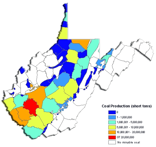
Map of 2002 West Virginia Coal Production by County in .pdf (wvcoalpr.pdf--113KB)
Do you need to download a copy of Adobe® Acrobat® Reader® in order to use the .pdf file?
- Where does most of the coal mined in West Virginia go? Was it any different in the past?
- In 2002,, 163,347,203 tons of coal were mined in West Virginia. West Virginia coal is used nationally
and internationally. In 1997, 38,450,000 tons were exported to foreign ports, representing about 46 percent
of the total coal exports from the United States. Much of the exported coal from West Virginia is used
for steel manufacturing. Of the remaining production, 37,142,000 tons were consumed in West Virginia, mainly
for electrical power generation, while 106,322,000 tons were shipped to other states, where electric utilities
consumed 79 percent, steel makers used 16 percent, and others consumed the remaining 5 percent (Source: West
Virginia Coal Association).
In recent decades, use of West Virginia coal for electrical power generation has increased, while use in
coke production for steel manufacturing has decreased. Earlier in the 1900s, West Virginia coal was used
extensively as fuel for steamships and steam locomotives.
- When was coal first mined in West Virginia?
- A trick question? The answer could be June 20, 1863, the day West Virginia attained statehood. Actually, there are written
references to coal being mined in the Kanawha Valley in the 1700s. For additional information, refer to
A Look at the History of Resource Development:
Coal.
- When did large-scale coal mining begin in southern West Virginia?
- Large-scale coal mining began in southern West Virginia after the Civil War. It was dependent on the completion of a
railroad transportation link to get the coal to markets. For more information, see
A Look at the History of Resource Development:
Coal.
- When did large-scale surface mining begin in West Virginia?
- Large-scale surface mining began in the 1950s, with the advent of large equipment. Additional sources of information include:
A Look at the History of Resource Development: Coal
and A Geologic Overview of Mountaintop Removal Mining in West
Virginia.
- What is a 'GIS'? How is the Survey using it?
- GIS stands for "Geographic Information System," a computerized system for the capture, storage,
management, analysis, and display of digital maps, images, and related databases that are referenced
with geographic coordinates.
Currently, the Survey is engaged in an aggressive program to map the coal beds of West Virginia using
GIS technologies and methodologies. For each important coal bed, geologists are creating structural (elevation)
contour maps, outcrop maps, mined-area maps, coal thickness and partings maps, and coal quality maps.
These GIS coverages are playing important roles in the West Virginia Department of Tax and Revenue's mineral
lands taxation program and are also very useful for investigating abandoned mine lands problems, in coal mine
permitting and regulation, in economic forecasting, and other applications. Click here
for more information about the Survey's GIS investigations in coal.
[West Virginia GeoFacts]
[Oil and Gas]
[General Geology, Geography]
[Environmental Issues, Water, Springs]
[Maps, Aerial Photographs, Satellite Imagery]
[Geology as a Profession]
(Return to top of FAQ Section)
- Where can I find information on oil and gas in my county?
- Elsewhere on our Web site, you can check the list of
publications for our county-based oil and gas reports, summary
data and drilling statistics, counts of available well
data, or counties at a glance. Or, contact our Oil
and Gas Section geologists. Several public and academic libraries in West Virginia maintain some of our publications in
their collections; check with your library for availability.
- What oil and gas fields are located in my area?
- There are 385 named oil and gas fields in the State (as of April 2003), and wells have also been drilled in areas between
fields or in areas in which fields have not yet been named. Contact our Oil and Gas Section geologists for more information.
- What formations produce gas and/or oil in my area?
- Check our county-based oil and gas reports (see the list of
publications), The Atlas of Major Appalachian Gas Plays (1996, Survey publication V-25),
recent drilling activity tables, or contact our Oil and
Gas Section geologists for more information.
- Do you have a record of the old gas well near my house?
- The Geological Survey has records for more than 150,000 wells drilled in the State. Approximately half of those were drilled
since permitting became required in 1929. For wells drilled prior to permitting, it is likely that we may have some
information about older wells, although this information may not be complete. Contact the Oil and Gas Records Office or Oil
and Gas Section geologists for more information.
- Do you have well production records?
- Production reporting became required in 1979. The Survey has production records for most wells since then, with monthly and
annual gas and oil volumes; days-on-line data were provided until 1986. Contact the Oil and Gas Records Office for
information on a specific well, or the Information Technology Section for formatted listings or ASCII files for data for
larger numbers of wells.
- How much gas and oil does West Virginia produce?
- For many years, West Virginia was the largest producer of natural gas east of the Mississippi River. In recent years, it
has still produced significant amounts of natural gas in the Appalachian Basin. Reported production in 2001 was 191 Bcf
(billion cubic feet) of natural gas and 1.607 million bbl (barrels) of oil.

Map of Gas Production only (for easier printing, etc.)
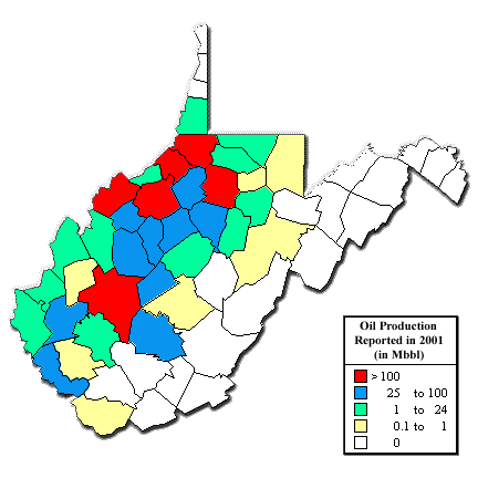
Map of Oil Production only (for easier printing, etc.)
- How long has oil and gas been drilled in West Virginia? Where can I find some historical information about the
oil and gas industry in the State?
- We have seen published illustrations of drilling and production activity in the Burning Springs area of Wirt County from the
late 1850s. Information on the history of the development of
the oil and gas industry in West Virginia, with comments on its importance during the Civil War, is available. An
excellent resource on the history of the development of the industry in the State is the Survey's "Petroleum and
Natural Gas, Precise Levels," a 1904 Survey publication (Volume- 1A) by then-Director I.C. White, which also
describes the development of the tools used for drilling by the salt industry in the Kanawha Valley.
Also, David L. McKain and Bernard L. Allen wrote an interesting history of the oil and gas industry in West Virginia in
their book "Where It All Began--The Story of the People and Places Where the Oil and Gas Industry Began--West
Virginia and Southeastern Ohio." An 1865 map at the beginning of the book shows the location of a well noted as
"first oil found 1790" near the town of Elizabeth in Wirt County.
The Oil and Gas Museum at 119 Third Street in Parkersburg is open on Saturdays and Sundays, with weekday and evening hours
available by appointment. Contact the museum at (304)428-8015. And, don't forget the Oil and Gas Festival held annually in
September in Sistersville in Tyler County.
- Where is the deepest well drilled in West Virginia?
- The deepest well was drilled in 1974 by Exxon USA in Calhoun County, to a depth of 20,222 feet, bottoming in the
Precambrian basement. The well, permit number 2503, was dry with a gas show in the Big Lime and oil shows in the Upper
Devonian shale and the Marcellus shale.
Wells drilled to the Precambrian basement are important to geologists because they provide a "view" of the complete
stratigraphic section of sedimentary rocks in a particular area, and they may provide information about the potential of a
variety of gas and/or oil reservoirs in the area.
| Deepest Wells in West Virginia |
| County |
Permit Number |
Total Footage |
Formation at Total Depth |
| Calhoun |
2503 |
20,222 feet deep |
Precambrian basement |
| Mingo |
805 |
19,600 feet deep |
Precambrian basement |
| Lincoln |
1469 |
19,124 feet deep |
Precambrian basement |
| Jackson |
1366 |
17,680 feet deep |
Precambrian basement |
| Marion |
244 |
17,111 feet deep |
Ordovician Beekmantown Formation |
| Marshall |
539 |
16,512 feet deep |
Cambrian Copper Ridge Dolomite |
| Hardy |
21 |
16,075 feet deep |
Cambro-Ordovician Rome Formation |
| Wayne |
1572 |
14,625 feet deep |
Precambrian basement |
| Preston |
86 |
14,594 feet deep |
Ordovician Black River Group |
| Hampshire |
12 |
13,999 feet deep |
Cambrian Elbrook Formation |
| Wood |
351 |
13,331 feet deep |
Precambrian basement |
| Wood |
756 |
13,266 feet deep |
Precambrian basement |
| Randolph |
103 |
13,121 feet deep |
Ordovician Trenton Group |
| Pendleton |
6 |
13,001 feet deep |
Ordovician Trenton Group |
| Grant |
2 |
13,000 feet deep |
Ordovician Beekmantown Formation |
For more information on the basement wells, see the Detailed Table of Basement Test Wells in West Virginia.
- What is the deepest occurrence of natural gas produced in West Virginia?
- The basement test well, Jackson 1366, produced gas from a Rome sand (Middle Cambrian age) at a depth of 14,358 feet for
about six months before mechanical problems forced the well to be plugged.
Otherwise, the deepest sustained gas production has been reported from the Upper Ordovician Trenton and Black River carbonates
in Roane County. The discovery well was drilled in 1999, and gas is produced from a depth of 10,271 feet. For more information on
this and other recently permitted and drilled wells, see Recently-Permitted
Trenton and Deeper Wells.
- What is the deepest occurrence of oil produced in West Virginia?
- In the mid-1980s, some oil was produced from the Balltown sand of Upper Devonian age at a depth of approximately 2,900 to
3,200 feet in the Belington field in southern Barbour County. Some oil was produced from Devonian shales in northwestern
West Virginia around the same time. A few wells produced oil from the Devonian Oriskany Sandstone at depths between 4,800
and 5,100 feet, and three wells produced oil from the Silurian Newburg sand at a depth of 5,500 to 5,800 feet.
- What field produced the largest amount of gas?
- The Elk-Poca field in Jackson, Kanawha, and Putnam counties has produced more than 1 Tcf (trillion cubic feet) of natural
gas from more than 1,000 wells since 1933.
- What field produced the largest amount of oil?
- The Salem-Wallace field in the north-central part of the State produced more than 41 million barrels of oil through 1960.
- What county has the most oil and/or gas wells?
- The Survey has records for more than 11,300 wells drilled in Ritchie County. Other densely-drilled counties include
Doddridge, Harrison, Kanawha, Lewis, Pleasants, and Roane.
- Who is in charge of regulating drilling and production of oil and gas wells in the State?
- The West Virginia Division of Environmental Protection's Office of Oil
and Gas has regulatory authority over oil and gas wells drilled and produced in the State.
- What are my rights as a surface owner?
- The West Virginia Surface Owners' Rights Organization can provide that information.
- Where can I get maps of well locations?
- The Survey has a collection of 7.5-minute quadrangle-based maps showing well locations available for public viewing, but not
copying, in our Oil and Gas Records Office. Computer-generated maps of well locations in any defined geographic area can be
plotted by the Survey's Information Technology Section. Contact our Oil and Gas Records Office for information about the
commercial availability of quadrangle maps showing well locations.
[West Virginia GeoFacts]
[Coal, Mining, Mine Subsidence]
[General Geology, Geography]
[Environmental Issues, Water, Springs]
[Maps, Aerial Photographs, Satellite Imagery]
[Geology as a Profession]
(Return to top of FAQ Section)
- What (and where) are the oldest and the youngest rocks in West Virginia?
- Rocks exposed at the surface in West Virginia range in age from Precambrian (about 570 million years old) to
Permo-Pennsylvanian (about 280 to 285 million years old).
The oldest bedrock (rock in place) exposed at the surface is found in the southeastern tip of Jefferson County.
These rocks, of the Catoctin Formation, are approximately 570 million years old (Precambrian age) and consist of
metamorphosed basalt lava flows. It is possible that some rock fragments even older than this (such as granites) were
transported in glacial till and occur in Ohio River outwash, but these are not native to West Virginia.
Other than Eocene intrusives in Pendleton County (see next question), the youngest bedrock in the State is found in the
Pittsburgh-Huntington Synclinorium (the Dunkard Basin), a broad basin in western West Virginia, southwestern Pennsylvania,
and southeastern Ohio. In West Virginia, the Dunkard Basin extends from the northern panhandle southward down the Ohio
River to about I-64 and east to about western Monongalia and Harrison and northern Roane counties. The youngest rocks in
this basin are sedimentary rocks of the Permo-Pennsylvanian Greene Formation of the Dunkard Group, approximately 280 to 285
million years old, and consist of sandstone, shale, mudstone, limestone, and coal.
- Are there any igneous rocks in West Virginia?
- There are no granite bodies exposed in West Virginia. Workers from the Survey have identified a number of "shallow,"
intrusive igneous dikes, sills, and plugs with compositions ranging from basalt to andesite that cut across sedimentary
rocks of Ordovician through Devonian age. These rocks are exposed at the surface in Pendleton County and are reported in
subsurface well drilling records from other counties such as Pocahontas.
These dikes, sills, and plugs are younger than the rocks they cut. Research by the U.S. Geological Survey and others
indicate that the majority of these igneous intrusive rocks are Middle Eocene in age and thus, are considerably younger than
the last stages of mountain-building associated with the Appalachian Orogeny or the Mesozoic rifting that opened the
present-day Atlantic Ocean. During the Middle Eocene, the eastern coast of North America is thought to have been a
"passive" continental margin, much like today. The presence of igneous activity in such a setting is unexpected and, as yet,
unexplained.
Other igneous activity preserved in the stratigraphic record is that of various volcanic ash falls. These are preserved
in Cambrian strata, in the Middle Ordovician Trenton Group, in the Tioga Metabentonite and others of Lower-Middle Devonian
age, and in the Hernshaw coal bed of the Middle Pennsylvanian Kanawha Formation.
- Are there any metamorphic rocks in West Virginia?
- Outcrops of four metamorphic formations occur along the eastern boundary of Jefferson County in the eastern panhandle.
The Precambrian metaigneous Catoctin greenstone consists of metamorphosed basalt lava flows. Three Lower Cambrian
metasedimentary formations include (from older to younger) the Weverton quartzite (a metamorphosed sandstone), Harpers
phyllite (a metamorphosed shale), and Antietam quartzite (a metamorphosed sandstone).
For more information:
- Geology of the Berryville, Charles Town, Harpers Ferry, Middleway, and Round Hill Quadrangles,
Jefferson County, WV: S.L. Dean, B.R. Kulander, and P. Lessing, 1990, West Virginia Geological and
Economic Survey Publication MAP-WV35.
- Cambrian System of West Virginia: H.P.Woodward, 1949, West Virginia Geological and
Economic Survey, Publication V-20.
- Why are some sedimentary rocks in West Virginia red? green? brown/black?
- The color of sedimentary rocks may be influenced by their mineral or organic content and may reflect
the environment in which they were formed. Reddish or greenish rocks are generally colored by different
oxidation states of iron. Brown, black, or very dark gray rocks generally contain large amounts of organic
matter and reflect deposition in an environment lacking oxygen. Want to know more? Click here.
- Is there gold in West Virginia?
- There has been no native gold or native silver recognized to date in West Virginia.
- Have any diamonds or precious gems been found in West Virginia?
- The third-largest diamond ever found in the United States, the "Punch" Jones Diamond, was found near Peterstown, in
Monroe County, within one-half mile of the Virginia state line. It has been suggested that the diamond actually occurred in
rocks in Virginia and that erosion carried it to the West Virginia side of the state line. There are no other likely sites
for diamonds in this State.
No other precious gems are known to have been found in West Virginia. While many gemstones are associated with igneous or
metamorphic rocks, most rocks exposed at the surface in this State are sedimentary rocks.
- Did dinosaurs ever exist in West Virginia?
- We know of no true dinosaur fossils found in the State because the sedimentary rocks in West Virginia are too old
(Paleozoic in age). Dinosaurs existed during the Mesozoic Era, but there are no known sedimentary rocks of Mesozoic age and
no known rocks derived from Mesozoic rocks in the State. Any Mesozoic rocks that might have covered the State have been
eroded away.
Dinosaur tracks and some bones are found in Mesozoic rocks in Pennsylvania, Maryland, and Virginia. We do know that the
youngest rocks in West Virginia (Permian age, Paleozoic Era) contain a rich record of four-legged amphibians and reptiles
that were ancestors of the dinosaurs.
- How much of West Virginia was covered by glaciers during the "Ice Age?"
- None of the State was covered by glacial ice during any of the ice advances in the Wisconsinan stage, the so-called
"Ice Age." However, West Virginia's climate at the time and a portion of the surface were affected by the presence of
glaciers to the north and northwest in Pennsylvania and Ohio. Want
to know even more?
- What was "Glacial Lake Monongahela?"
- Glacial Lake Monongahela was formed when outwash, or possibly ice, dammed the northward-flowing Monongahela River and its
tributaries at least once, forming a large lake extending south towards Lewis County. This dam was probably located just
above the tip of the northern panhandle of West Virginia. At its highest level, Lake Monongahela was 200 miles long and 100
miles wide, and flooded all land below 1,100 feet in elevation in parts of northwestern West Virginia and southwestern
Pennsylvania. Another major lake associated with the glacial period was Glacial Lake Teays, located in the
Kanawha-Huntington area. Still interested?
- What is the age of the New River?
- From the headwaters of the New River at Blowing Rock, North Carolina, to the junction of the Kanawha River with the Ohio
River, there is a valley demonstrating the enormous powers of erosion by running water. Because this river transects the
Appalachian Mountains, people have attempted to assign an age to the river based on the age of the mountains; all estimates
are uncertain and hypothetical. We cannot scientifically define a precise age for the New River because there is no method
to date rivers.
Further information:
"Geology of the New River Gorge"
- Are there earthquakes in West Virginia?
- From time to time, earthquakes are felt in West Virginia. The vast majority of these quakes originate below the surface of
adjacent states, especially Virginia, Kentucky, and Ohio. In general, the eastern earthquakes originating near our borders
are not that damaging. You may feel an earthquake in your lifetime, but chances are it will do little but rattle cups and
dishes in your home.
- The U.S. Geological Survey (USGS) maintains a web site that provides information about West Virginia earthquakes and earthquake hazards at
http://earthquake.usgs.gov/regional/states.php?regionID=48
- Are there volcanoes in West Virginia?
- No, and geologically there is no reason to expect one to appear. There is evidence, however, of multiple ash falls from
ancient volcanoes preserved in rocks of Cambrian, Ordovician, and Devonian age in outcrops in eastern West Virginia and in
the subsurface in the western part of the State, and in a flint clay in the Hernshaw coal bed of Middle Pennsylvanian age
(Kanawha Formation) in southern West Virginia. The sources of these ash falls are speculated to have been ancient
volcanoes--long ago eroded--to the southeast of what is now West Virginia. All of these events occurred more than 300
million years ago.
- What is the geology like under my land?
- The Appalachian Plateau Province of the western two-thirds of the State generally consists of relatively flat-lying,
relatively younger sedimentary rocks of Permian, Pennsylvanian, and Mississippian age exposed at the surface. The Valley
and Ridge Province of the eastern third of the State contains folded, relatively-older sedimentary rocks of Devonian,
Silurian, Ordovician, and Cambrian age. The Allegheny Front separates the two provinces. Refer to the
geologic map of the State or the
description of the physiographic provinces of the State
elsewhere on our Web site, or contact our Service Section for
more information about your specific area.
- What kind of rock is this? What kind of fossil is this?
- Our Service Section staff can answer these questions for you.
- Where can I find gemstones in West Virginia?
- Only a limited variety of gemstones are found in West Virginia, because the types of rocks found in the State are not those
associated with the formation of most gemstones. Most natural gems are hard minerals formed from the crystallization of
gases and fluids in the earth and are found with either igneous rocks (solidified molten material) or metamorphic rocks
(changed by heat, pressure, or chemical reaction). However, almost all of West Virginia's rocks exposed at the surface are
of sedimentary origin: they formed from matter deposited by water or wind. The end result is few gemstones.
Among the few gemstones found in West Virginia are some opal, some types of quartz, and two coal or coal-like minerals
which, though softer than most gemstones, are cut, polished, and carved into jewelry. Want to know a little more about West Virginia minerals?
A word of caution is necessary if you plan to enter any property searching for minerals, rocks, or gemstones:
it should be done only with the permission of the property owner. In State parks and all caves in West Virginia, removal of
gemstones or any other rock or mineral formation is prohibited by law. Also, be alert for such things as rock slides,
poison ivy, snakes, and other hazards when searching areas for gemstones.
- Who "owns" the Ohio River?
- West Virginia "owns" the Ohio River and the islands in it to the low water mark on the Ohio side of the river along our
border with that state. As you drive across any of the bridges over the Ohio River, note where the "Welcome to . . . "
signs appear. They should reflect that you are in West Virginia when you are over the river.
- I am interested in genealogy. Where can I find information on place names in West Virginia?
- A good place to start is the Survey's West Virginia Gazetteer of Physical and Cultural Place Names
(West Virginia Geological and Economic Survey Publication V-24, 1986), a compendium of more than 30,000 place names that
occurred on several vintages of maps in the State. Our field geologists have also recorded a number of local names of
hollows; these names have been added to our computer database. Contact our Service Section for more information.
[West Virginia GeoFacts]
[Coal, Mining, Mine Subsidence]
[Oil and Gas]
[Environmental Issues, Water, Springs]
[Maps, Aerial Photographs, Satellite Imagery]
[Geology as a Profession]
(Return to top of FAQ Section)
- Is a landslide likely to occur on my property?
- Because of the relatively steep relief in much of the State, landslides are a real hazard wherever slopes are disturbed
by erosion or construction. The Survey has published 36 7.5-minute topographic maps overprinted with landslide information
(see description for Survey publication EGB-15).
Contact Publication Sales for more information about the maps. For more information about your specific area, contact our
Service Section with your precise location.
- Why has the creek turned acidic?
- The creek is most likely in West Virginia's high ash/high sulfur Northern Coal Field. Most of the acid drainage originates
from abandoned underground mines. Other sources of acidic drainage include active underground and surface coal mines,
surface accumulations of rock waste from underground mines and coal cleaning plants, unreclaimed surface mines, and
unsuccessfully reclaimed surface mines. Tell me more!
- Why would my water well go dry?
- Well failure and aquifer failure are the two reasons why water wells go dry. A water well fails when it no longer transmits
water from the aquifer to the pump intake. In West Virginia, this is usually caused by corrosion and scale and occasionally
by algae, bacteria, or improper well development.
An aquifer fails when the water table falls below the bottom of the well. This can result from insufficient water being
supplied to the aquifer (as in times of drought), dewatering of the aquifer because of overuse, or diversion of ground water
away from the well and into a mine, road cut, or deeper aquifer.
Further reading: A Practical Handbook for Individual Water Supply Systems in West Virginia:
West Virginia Geological and Economic Survey, 1979, Publication ED-11, 110 p.
- Are there any natural springs in my area?
- Tens of thousands of springs occur in West Virginia. Nearly 1,200 of the most prominent documented springs are described in
the Survey's Springs of West Virginia publication (1986, Volume 6A), with precise locations and
some flow, temperature, or water quality data for springs in 49 of the State's 55 counties. Springs do exist in the other 6
counties, but they are not documented in the Springs publication.
For more information about your precise area, contact the Survey's Service Section or Environmental Geologist.
- What is the overall water quality in West Virginia? How is it tested?
- Water quality involves complex issues that do not have simple answers. Many factors
affect water quality, including climate, geology, soils, and human activities. The intended use
of the water determines if the water quality is satisfactory for that use. For example, water that is
suitable for industrial use many not be appropriate for use as drinking water.
Water quality is tested by chemical analysis. The analytical procedures used and the type and frequency
of sampling depend on who is conducting the sampling program. In West Virginia, several State and federal
agencies evaluate water quality, as well as educational institutions, private industries, and others.
The U.S. Environmental Protection Agency (EPA) maintains a web site
that provides maps showing water quality characterization by watershed, along with other environmental
information, including Superfund sites.
- Where can I get copies of water well logs?
- County Health Departments maintain information about water-well drilling
permits and water well logs. Contact information is available at http://www.wvdhhr.org/phs/LHD.pdf
- Where can I get a water table map?
- Maps showing depth to the water table are not available for West Virginia.
For more information about your precise area, contact the Survey's Service Section.
- Where can I find information about water in my area?
- Information about water is available by watershed in WVGES water publications.
Monongahela River Watershed (Click here)
Little Kanawha River Watershed (Click here)
Potomac River Watershed (Click here)
Upper Greenbrier Watershed (Click here)
Coal River Watershed (Click here)
Elk River Watershed (Click here)
Guyandotte River Watershed (Click here)
Tug Fork of Big Sandy River Watershed (Click here)
- Hydrologic ground-water atlases of nine West Virginia river basins are available from the West Virginia Department of Environmental Protection, Division of Water and Waste Management. For more information about ordering these atlases, see http://www.wvgs.wvnet.edu/www/services/servpubc.htm#Hydrolog
[West Virginia GeoFacts]
[Coal, Mining, Mine Subsidence]
[Oil and Gas]
[General Geology, Geography]
[Maps, Aerial Photographs, Satellite Imagery]
[Geology as a Profession]
(Return to top of FAQ Section)
- Where can we get topographic maps for our hunting or camping trip?
- The Geological Survey sells 7.5-minute-series topographic maps (at a scale of 1:24,000) with the green forest overlay; some
quadrangles may be available without the green forest overlay. The current price of a 7.5-minute-series topographic map is
$4.00, plus postage and sales tax (if mailed to an address in West Virginia).
Call our Publication Sales Office about the availability of two other map series, 1:100,000-scale (30-minute by 60-minute),
and 1:250,000-scale (1 degree x 2 degrees).
- How can I order topographic maps?
- You can call, send a letter, FAX an order, or visit our
Publication Sales Office to place orders for maps or publications. Ordering directly via the Web site is not yet
operational.
- Where can I get old aerial photographs of my county? How about recent aerial photographs?
- Old and recent aerial photographs are available through the Survey's Earth Science Information Center (ESIC). For prices and
availability of your specific location, contact the ESIC Office at the Survey.
[West Virginia GeoFacts]
[Coal, Mining, Mine Subsidence]
[Oil and Gas]
[General Geology, Geography]
[Environmental Issues, Water, Springs]
[Geology as a Profession]
(Return to top of FAQ Section)
- What classes should a student take in high school if he or she is interested in majoring in geology in college?
- A high school college-prep program, including a background in math through algebra II and trigonometry, and four
years of science (including coordinated science 9 and 10 in West Virginia and other choices from a
menu that might include biology, chemistry, earth science, or physics) will generally prepare a student
to begin a college program in geology. In college, many geology departments require additional math (often
at the calculus level) and science (such as chemistry and physics) as part of their degree programs.
Additionally, the ability to use a computer is a must for today's geologists. The potential geology
major should take every opportunity to learn to use computer hardware and software.
- What kinds of jobs are available for geologists? Where do geologists work?
- Geologists are hired to work in federal/state/county/local governments, education at the secondary
and college levels, various private industries, in consulting, and investment firms (such as large banks),
in a variety of capacities. They work in the following disciplines: energy and extractive mineral industries
(oil and gas, coal, or other mineral resources); environmental geology; ground water or surface water; waste
disposal; geomorphology; paleontology; marine geology; palentary sciences; analytical and computer applications;
planning/engineering; and much, much more.
For further information, check out the Careers in the Geosciences
section on the American Geological Institute's web site.
- What are the requirements for becoming a registered geologist in West Virginia?
- West Virginia does not have professional registration for geologists at this time. Other states such as Pennsylvania,
Kentucky, and Virginia do have formal registration or certification procedures. Some geologists practicing in West Virginia
are registered in other states or are certified by such organizations as the American Institute of Professional Geologists or
Division of Professional Affairs of the American Association of Petroleum Geologists.
[West Virginia GeoFacts]
[Coal, Mining, Mine Subsidence]
[Oil and Gas]
[General Geology, Geography]
[Environmental Issues, Water, Springs]
[Maps, Aerial Photographs, Satellite Imagery]
(Return to top of FAQ Section)


Page last revised: December 11, 2008
Please send questions, comments, and/or suggestions to webmaster.
Page created and maintained by:
            West Virginia Geological and Economic Survey
  Address:  Mont Chateau Research Center
            1 Mont Chateau Road
            Morgantown, WV  26508-8079
Telephone:  304-594-2331
      FAX:  304-594-2575
    Hours:  8:00 a.m. - 5:00 p.m. EST, Monday - Friday
Permission to reproduce this material is granted if acknowledgment is given
to the West Virginia Geological and Economic Survey.
