|
GIS Research & Applications |
GIS Database Development |
Spatial Data Analysis |
Geovisualization Tools Development |
Communication of Georeferenced Statistics
- Enterprise GIS
- Geographic Information System for Breast Cancer Studies on Long Island
- Related Collaborative Research
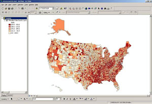
Many geospatial analyses at NCI include input data from many sources, such
as mortality data from the National Center for Health Statistics, data from
the Census Bureau, and
lifestyle data from CDC. We have compiled a database
of commonly used geospatial data into an Enterprise GIS system for use by
NCI DCCPS staff. This single database will provide staff with easily
accessible current data in a consistent geography.
- Goal: Provide comprehensive, consistent, easily maintained geospatial data for NCI division staff
- Content: Cancer rates and trends; sociodemographic, medical resource, behavioral risk factor data
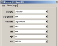
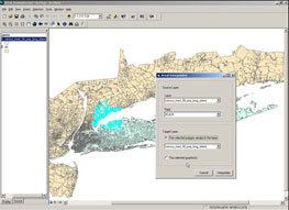
- System architecture:
- Visual Basic Form called from a VB .NET dll from within ArcMap
- This program makes an internet call to a PHP program which retrieves data from Sybase database
- Resulting text file is written to user’s hard drive, joined to shapefile
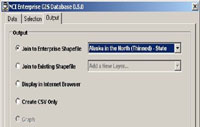
| Selection: |
|
Output: map or text file |
 |
 |
 |
Long Island Breast Cancer Study Project
A Resource for Researchers and the Public
Geographic Extent of LI GIS
 [D] [D]
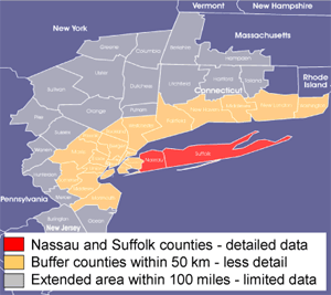
The Long Island Geographic Information System (LI GIS)
is a GIS comprising data with statistical and spatial extensions. The LI GIS is designed to study the potential
relationships between environmental exposures and breast cancer on Long Island. It also
can be used to study other diseases.
The LI GIS is one of a series of major studies and initiatives within the Long
Island Breast Cancer Study Project (LIBCSP), congressionally mandated activities to understand
breast cancer incidence rates on Long Island. Researchers can apply online to use the entire LI GIS and/or the
LI GIS statistical software and spatial extensions.
The LI GIS warehouse contains over 80 datasets covering:
- Topographic;
- Demographic;
- Health outcome, including relative breast cancer incidence; and
- Environmental data for Nassau and Suffolk counties, and to a lesser extent on surrounding counties.
Researcher's toolbox
The LI GIS project makes use of a full suite of GIS software and extensions
related to study of breast cancer.
- ESRI ArcGIS software suite
- ArcView & ArcInfo
- Spatial Analysis & 3D Analyst
- Extensions for epidemiological studies:
- Case File Formatter
- Disease Rate Calculator
- Areal Interpolator
- Cluster Analysis Tool (using SaTScan)
- Empiricial Bayes Tool
- EpiAnalyst
- S-Plus Spatial Stats
- Geographic masking
- SAS
- Additional ArcView extensions and software
- Oracle 9i
- Online User's Guide
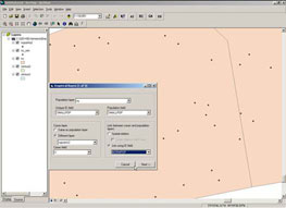
| Example: Arial interpolator -- interpolating zip code population from census tract population |
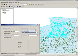
Example: Disease rate calculator -- calculating directly-adjusted rate for selected census tracts |
 |
 |
 |
 |
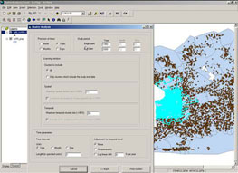
| Example: Cluster analysis -- checking for clusters of sample cases in Suffolk County (SaTScan) |
Example: Empirical Bayes Tool – stabilizes data. Deals with small numbers issues for local data |
The SEER program funds special research studies by its cancer registries on
topics of interest to NCI and cancer registries in general. Recent studies
related to geospatial methods are:
- Development of high resolution population distribution data for cancer control
- Assessment of the accuracy of geocoding by geographic scale, impact of errors on cancer rates
GIS Research & Applications |
GIS Database Development |
Spatial Data Analysis |
Geovisualization Tools Development |
Communication of Georeferenced Statistics
|