| USGCRP
Home |
| Search |
|
Updated 16 September 2008
|
Land Use and
Land Cover Change |
| USGCRP
Home |
| Search |
|
Updated 16 September 2008
|
Land Use and
Land Cover Change |
|
Land Use / Land Cover ChangeOverview Archived News Postings [November 2002 - July 2005] CCSP / USGCRP Land Use & Land Cover Change Working Group Members
|
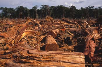
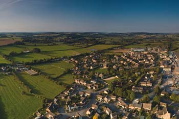
The global climate system is affected by land-use and land-cover changes through biogeophysical, biogeochemical, and energy exchange processes. These changes in turn affect climate at local, regional, and global scales. Key processes include uptake and release of greenhouse gases by the land cover of the terrestrial biosphere to and from the atmosphere through photosynthesis, respiration, and evapotranspiration; the release of aerosols and particulates from surface land-cover change perturbations; variations in the exchange of sensible heat between the surface and atmosphere due to land-cover changes; variations in absorbance and reflectance of radiation as land-cover changes affect surface albedo; and surface roughness effects on atmospheric momentum that are land cover-dependent. While human activity can alter many of these processes, weather, climate, and geological processes are also important.
For example, changes in land cover modify the reflectance of the land surface, determining the fraction of the Sun’s energy absorbed by the surface and thus affecting heat and moisture fluxes. These processes also alter vegetation transpiration and surface hydrology and determine the partitioning of surface heat into latent and sensible heat fluxes. At the same time, vegetation and urban structure determine surface roughness, thus air momentum and heat transport. In addition, deforestation and forest fires alter ecosystems and release carbon dioxide (CO2), methane (CH4), carbon monoxide, and aerosols to the atmosphere. Land-use and land-cover change studies also provide valuable information for largescale vegetation biomass and forest cover assessments that are key components of the carbon cycle. Future land-use and land-cover change goals include (1) very accurate biomass estimates, thus refining knowledge of carbon storage in vegetation, (2) understanding regional land-use changes that affect biomass, and (3) quantifying linkages and feedbacks between land-use and land-cover change, climate change forcings, climate change, and other related human and environmental components. Research that examines historic, current, and future land-use and land-cover change, its drivers, feedbacks to climate, and its environmental, social, economic, and human health consequences is therefore of great importance for understanding climate and requires interagency and intergovernmental cooperation. One example of a multiagency effort is the Congo Basin Forest Partnership, which focuses on conserving this rainforest in equatorial Africa, the second largest tropical rainforest in the world. Satellite data are used to map forest extent, determine habitat fragmentation, enforce conservation laws, and thus minimize greenhouse gas emissions from deforestation land-use changes. Another example is the North American Carbon Initiative that seeks to understand the carbon cycle for North America. |
|
 Land use and land cover are linked to climate and weather in complex ways and are critical inputs for modeling greenhouse gas emissions, carbon balance, and ecosystems. Land-use and land-cover change (LULCC) studies have provided critical inputs to large-scale biomass and forest cover assessments; future LULCC goals include reducing uncertainties in biomass estimates, understanding regional heterogeneities in changes, and quantifying linkages and feedbacks between LULCC, climate change, and other human and environmental components. Research that examines historic, current, and future LULCC, its drivers, feedbacks to climate, and its environmental, social, economic, and human health consequences is therefore of utmost importance and often requires interagency and intergovernmental cooperation. Research plans focus on how management practices may change as climate and conservation policies change, and on feedbacks related to environmental, social, economic, and human health.