|
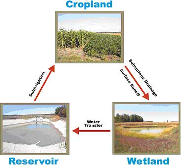
A Wetland Reservoir Subirrigation System, or WRSIS for short, is an innovative agricultural water management system. WRSIS is comprised of a wetland and a water storage reservoir linked to a network of subsurface pipes used at different times to either drain or irrigate crops through the root zone. Runoff and subsurface drainage are collected from cropland into a constructed wetland. Natural processes in the wetland treat the water by removing some of the nutrients, pesticides, and sediment. The water is then routed to a storage reservoir and held until needed to subirrigate the crops during dry parts of the growing season. The storage reservoir also provides a further opportunity for sediment and adsorbed nutrients to settle out of the water. The integration of these components allows WRSIS to operate in a closed loop mode most of the time, thus restricting offsite water release (fig. 1). WRSIS can offer a number of benefits including (1) enhanced crop yields, (2) reduced offsite release of nutrients, pesticides, and sediment, (3) additional wetland vegetation and wildlife habitat, (4) more carbon sequestration in soil, and possibly, (5) decreased flooding potential downstream.
WRSIS Fact Sheet
(This PDF file contains most of the information on these pages.)
|