Landsat 7
Full Name: LANDSAT 7
Phase: Operating
Launch Date: April 15, 1999
Mission Project Home Page: http://landsat.gsfc.nasa.gov/
Program(s): Earth Systematic Missions
Landsat 7 systematically provides well-calibrated, multispectral, moderate resolution, substantially cloud-free, Sun-lit digital images of the Earth's continental and coastal areas with global coverage on a seasonal basis. It covers the United States every 16 days. Operations were transferred to USGS on Fall 2000.
The Landsat Project is a joint initiative of the U.S. Geological Survey (USGS) and the NASA to gather Earth resource data using a series of satellites. NASA was responsible for developing and launching the spacecrafts, while the USGS is responsible for flight operations, maintenance, and management of all ground data reception, processing, archiving, product generation, and distribution.
The primary objective of the Landsat Project is to ensure a collection of consistently calibrated Earth imagery. Landsat's Global Survey Mission is to establish and execute a data acquisition strategy that ensures repetitive acquisition of observations over the Earth's land mass, coastal boundaries, and coral reefs; and to ensure the data acquired are of maximum utility in supporting the scientific objectives of monitoring changes in the Earth's land surface and associated environment.
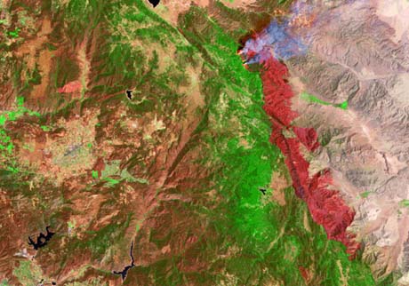
Fires burned east of San Diego after a helicopter accidentally clipped power lines
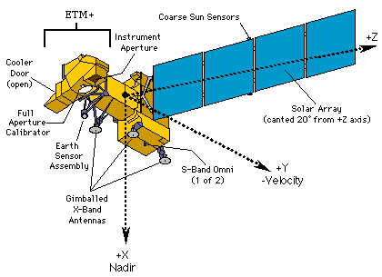
Landsat is the longest-running project for acquisition of moderate resolution imagery of the Earth from space. The Landsat 1 satellite was launched in 1972; the most recent, Landsat 7, was launched in 1999. Landsat 7 is a 5000 pound-class satellite designed for a 705 km, Earth mapping orbit with a 16-day repeat cycle. Its payload is a single nadir-pointing instrument, the Enhanced Thematic Mapper Plus (ETM+). The ETM+ provides for an eight-band multispectral scanning radiometer capable of providing high-resolution image information of the Earth's surface. The ETM+ is designed to collect, filter and detect radiation from the Earth in a swath 185 km wide as it passes overhead. It produces approximately 3.8 gigabits of data for each scene, which is roughly equivalent to nearly 15 sets of encyclopedias at 29 volumes per set.