ICESat
Full Name: Ice, Clouds, and Land Elevation Satellite
Phase: Operating
Launch Date: January 12, 2003
Mission Project Home Page: http://icesat.gsfc.nasa.gov/
Program(s): Earth Systematic Missions
ICESat (Ice, Cloud,and land Elevation Satellite) is the benchmark Earth Observing System mission for measuring ice sheet mass balance, cloud and aerosol heights, as well as land topography and vegetation characteristics. The ICESat mission provides multi-year elevation data needed to determine ice sheet mass balance as well as cloud property information, especially for stratospheric clouds common over polar areas. It also provides topography and vegetation data around the globe, in addition to the polar-specific coverage over the Greenland and Antarctic ice sheets.
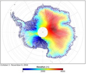
The colors on the map above represent ICESat’s measurements of Antarctica’s topography, using data collected from October 3 through November 8, 2004. Red shows the highest elevations (up to 4,000 meters above sea level). Yellow, green, and turquoise show progressively lower elevations (green is 2,000 meters above sea level). Dark blue shows sea level.
Image Credit: Christopher Shuman, ICESAT/NASA
Are the ice sheets that still blanket the Earth' poles growing or shrinking? Will global sea levels rise or fall? NASA has developed the ICESat mission to provide answers to these and other questions--to help fulfill NASA' mission to understand and protect our home planet. The primary goal of ICESat is to quantify ice sheet mass balance and understand how changes in the Earth' atmosphere and climate affect polar ice masses and global sea level. ICESat is also measuring the distribution of clouds and aerosols, as well as surveying land topography, sea ice, and vegetation cover.
Ice sheets are complex and dynamic elements of our climate system. Their evolution has strongly influenced sea level in the past and currently influences the global sea level rise that threatens our coasts. Ice streams that speed up, slow down, and change course illustrate their dynamic nature. Atmospheric factors cause snowfall to vary in space and time across their surfaces. In Antarctica, small ice shelves continue to retreat along the Antarctic Peninsula, and large icebergs are released from its largest ice shelves. In Greenland, the ice margins appear to be thinning and the inland parts of the ice sheet may be thickening. Surface melt water seeps into the ice sheets and accelerates their flow. Some of the factors controlling the mass balance of ice sheets, and their present and future influences on sea level, are just beginning to be understood.
The ICESat mission, part of NASA' Earth Observing System (EOS), was launched in January 2003. The Geoscience Laser Altimeter System (GLAS) on ICESat measures ice sheet elevations, changes in elevation through time, height profiles of clouds and aerosols, land elevations and vegetation cover, and approximate sea ice thickness. Future ICESat missions will extend and improve assessments from the first mission, as well as monitor ongoing changes. Together with other aspects of NASA Earth science and current and planned EOS satellites, ICESat will enable scientists to study the Earth' climate and, ultimately, predict how ice sheets and sea level will respond to future climate change.