Mars Reconnaissance Orbiter (MRO)
Full Name: Mars Reconnaissance Orbiter
Phase: Operating
Launch Date: August 12, 2005
Mission Project Home Page: http://mars.jpl.nasa.gov/mro/
Program(s): Mars Exploration
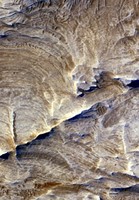
Light-Toned Bedrock Along Cracks
as Evidence of Fluid Alteration
This image was taken in September 2006 by the High Resolution Imaging Science Experiment camera aboard NASA's Mars Reconnaissance Orbiter. The haloes visible along fractures seen in the Candor Chasma image appear to be slightly raised relative to surrounding, darker rock. This is evidence that the circulating fluids hardened the lining of the fractures, as well as bleaching it.
The most likely origin for these features is that minerals that were dissolved in water came out of solution and became part of the rock material lining the fractures. These fluids may have produced conditions to support possible habitats for microbial life.
Image credit: NASA/JPL-Caltech/Univ. of Arizona
NASA's Mars Reconnaissance Orbiter, launched August 12, 2005, is on a search for evidence that water persisted on the surface of Mars for a long period of time.
MRO carries the most powerful camera ever flown on a planetary exploration mission for homing in on details of Martian terrain with extraordinary clarity. While previous cameras on other Mars orbiters were able to identify objects no smaller than a dinner table, this camera will be able to spot something as small as a dinner plate. This capability will not only provide an astoundingly detailed view of the geology and structure of Mars, but will help identify obstacles that could jeopardize the safety of future landers and rovers.
The Mars Reconnaissance Orbiter also carries a sounder to find subsurface water, an important consideration in selecting scientifically worthy landing sites for future exploration. Other science instruments on this multitasking, multipurpose spacecraft can identify surface minerals and study how dust and water are transported in the Martian atmosphere. A second camera provides medium-resolution images to provide a broader geological and meteorological context for more detailed observations from higher-resolution instruments.
These studies will help determine if there are deposits of minerals that form in water over long periods of time, detect any shorelines of ancient seas and lakes, and analyze deposits placed in layers over time by flowing water. It will also be able to tell if the underground martian ice discovered by the Mars Odyssey orbiter is the top layer of a deep ice deposit or whether it is a shallow layer in equilibrium with the current atmosphere and its seasonal cycle of water vapor.
The orbiter also carries an experimental navigation camera. If it performs well, similar cameras placed on orbiters of the future would be able to serve as high-precision interplanetary "eyes" to guide incoming landers to precise landings on Mars, opening up exciting - but otherwise dangerous - areas of the planet to exploration.
The orbiter's telecommunications systems will also establish a crucial service for future spacecraft, becoming the first link in a communications bridge back to Earth, an "interplanetary Internet" that can be used by numerous international spacecraft in coming years. Testing the use of a radio frequency called Ka-band, Mars Reconnaissance Orbiter may demonstrate the potential for greater performance in communications using significantly less power.
The orbiter's primary mission ends about five-and-a-half years after launch, on December 31, 2010. This mission is part of the Mars Exploration Program.